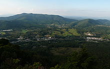
- Ashe County
-
Verwaltung US-Bundesstaat: North Carolina Verwaltungssitz: Jefferson Adresse des
Verwaltungssitzes:County Courthouse
150 Government Circle
Jefferson, NC 28640-9378Gründung: 18. November 1799 Gebildet aus: Wilkes County Vorwahl: 001 336 Demographie Einwohner: 24.384 (2000) Bevölkerungsdichte: 22,1 Einwohner/km² Geographie Fläche gesamt: 1.105 km² Wasserfläche: 2 km² Karte Website: www.ashecountygov.com Ashe County[1] ist ein County im Bundesstaat North Carolina der Vereinigten Staaten von Amerika. Der Verwaltungssitz (County Seat) ist Jefferson, das nach dem Präsidenten Thomas Jefferson benannt wurde.
Inhaltsverzeichnis
Geografie
Das County liegt im äußersten Nordwesten von North Carolina, grenzt im Norden an Virginia, im Westen an Tennessee und hat eine Fläche von 1105 Quadratkilometern, wovon 2 Quadratkilometer Wasserfläche sind. Es grenzt in North Carolina im Uhrzeigersinn an folgende Countys: Alleghany County, Wilkes County und Watauga County.
Ashe County ist in 19 Townships aufgeteilt: Chestnut Hill, Clifton, Creston, Elk, Grassy Creek, Helton, Horse Creek, Hurricane, Jefferson, Laurel, North Fork, Obids, Old Fields, Peak Creek, Pine Swamp, Piney Creek, Pond Mountain, Walnut Hill und West Jefferson.
Geschichte
Ashe County wurde am 18. November 1799 aus Teilen des Wilkes County gebildet. Benannt wurde es nach Samuel Ashe, dem neunten Gouverneur von North Carolina und Patrioten im Amerikanischen Unabhängigkeitskrieg.
Demografische Daten
Historische Einwohnerzahlen Census Einwohner ± in % 1800 2783 — 1810 3694 30 % 1820 4335 20 % 1830 6987 60 % 1840 7467 7 % 1850 8777 20 % 1860 7956 -9 % 1870 9573 20 % 1880 14.437 50 % 1890 15.628 8 % 1900 19.581 30 % 1910 19.074 -3 % 1920 21.001 10 % 1930 21.019 0,09 % 1940 22.664 8 % 1950 21.878 -3 % 1960 19.768 -10 % 1970 19.571 -1 % 1980 22.325 10 % 1990 22.209 -0,5 % 2000 24.384 10 % Vor 1900[2] Nach der Volkszählung im Jahr 2000 lebten im Ashe County 24.384 Menschen. Davon wohnten 301 Personen in Sammelunterkünften, die anderen Einwohner lebten in 10.411 Haushalten und 7.423 Familien. Die Bevölkerungsdichte betrug 22 Einwohner pro Quadratkilometer. Ethnisch betrachtet setzte sich die Bevölkerung zusammen aus 97,16 Prozent Weißen, 0,66 Prozent Afroamerikanern, 0,32 Prozent amerikanischen Ureinwohnern, 0,23 Prozent Asiaten, 0,01 Prozent Bewohnern aus dem pazifischen Inselraum und 1,05 Prozent aus anderen ethnischen Gruppen; 0,56 Prozent stammten von zwei oder mehr Ethnien ab. 2,42 Prozent der Bevölkerung waren spanischer oder lateinamerikanischer Abstammung.
Von den 10.411 Haushalten hatten 26,2 Prozent Kinder unter 18 Jahren, die bei ihnen lebten. 59,4 Prozent davon waren verheiratete, zusammenlebende Paare, 8,4 Prozent waren allein erziehende Mütter und 28,7 Prozent waren keine Familien. 25,8 Prozent waren Singlehaushalte und in 12,1 Prozent lebten Menschen mit 65 Jahren oder älter. Die Durchschnittshaushaltsgröße betrug 2,31 und die durchschnittliche Familiengröße war 2,75 Personen.
19,8 Prozent der Bevölkerung waren unter 18 Jahre alt. 7,5 Prozent zwischen 18 und 24 Jahre, 27,0 Prozent zwischen 25 und 44 Jahre, 27,7 Prozent zwischen 45 und 64, und 18,0 Prozent waren 65 Jahre alt oder Älter. Das Durchschnittsalter betrug 42 Jahre. Auf alle weibliche Personen kamen 97,4 männliche Personen. Auf alle Frauen im Alter von 18 Jahren oder darüber kamen 94,9 Männer.
Das jährliche Durchschnittseinkommen eines Haushalts (Median) betrug 28.824 US-$, das Durchschnittseinkommen einer Familie 36.052 $. Männer hatten ein durchschnittliches Einkommen von 25.666 $, Frauen 19.983 $. Das Prokopfeinkommen betrug 16.429 $. 13,5 Prozent der Bevölkerung und 10,1 Prozent der Familien lebten unterhalb der Armutsgrenze. 16,3 Prozent von ihnen sind Kinder und Jugendliche unter 18 Jahre und 17,3 Prozent sind 65 Jahre oder älter. [5]
Städte und Gemeinden
- Jefferson
- Lansing
- Ore Knob
- Transou
- West Jefferson
Siehe auch
Einzelnachweise
- ↑ GNIS-ID: 1008535. Abgerufen am 22. Februar 2011 (englisch).
- ↑ U.S. Census Bureau - Census of Population and Housing. Abgerufen am 15. März 2011
- ↑ Auszug aus Census.gov. Abgerufen am 20. Februar 2011
- ↑ Auszug aus factfinder.census.gov Abgerufen am 20. Februar 2011
- ↑ Ashe County, North Carolina, Datenblatt mit den Ergebnissen der Volkszählung im Jahre 2000 bei factfinder.census.gov.
Liste der Countys in North Carolina
Alamance | Alexander | Alleghany | Anson | Ashe | Avery | Beaufort | Bertie | Bladen | Brunswick | Buncombe | Burke | Cabarrus | Caldwell | Camden | Carteret | Caswell | Catawba | Chatham | Cherokee | Chowan | Clay | Cleveland | Columbus | Craven | Cumberland | Currituck | Dare | Davidson | Davie | Duplin | Durham | Edgecombe | Forsyth | Franklin | Gaston | Gates | Graham | Granville | Greene | Guilford | Halifax | Harnett | Haywood | Henderson | Hertford | Hoke | Hyde | Iredell | Jackson | Johnston | Jones | Lee | Lenoir | Lincoln | Macon | Madison | Martin | McDowell | Mecklenburg | Mitchell | Montgomery | Moore | Nash | New Hanover | Northampton | Onslow | Orange | Pamlico | Pasquotank | Pender | Perquimans | Person | Pitt | Polk | Randolph | Richmond | Robeson | Rockingham | Rowan | Rutherford | Sampson | Scotland | Stanly | Stokes | Surry | Swain | Transylvania | Tyrrell | Union | Vance | Wake | Warren | Washington | Watauga | Wayne | Wilkes | Wilson | Yadkin | Yancey
Wikimedia Foundation.


