- Richmond County (North Carolina)
-
Verwaltung US-Bundesstaat: North Carolina Verwaltungssitz: Rockingham Adresse des
Verwaltungssitzes:County Administration Building
P.O. Box 504
Rockingham, NC 28380-0504Gründung: 1779 Gebildet aus: Anson County Vorwahl: 001 910 Demographie Einwohner: 46.564 (2000) Bevölkerungsdichte: 37,9 Einwohner/km² Geographie Fläche gesamt: 1.242 km² Wasserfläche: 14 km² Karte 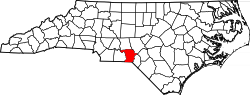
Website: www.co.richmond.nc.us Richmond County[1] ist ein County im Bundesstaat North Carolina der Vereinigten Staaten von Amerika. Im Jahr 2000 hatte das County 46.564 Einwohner und eine Bevölkerungsdichte von 38 Einwohnern pro Quadratkilometer. Der Verwaltungssitz (County Seat) ist Rockingham, das nach dem Marquis of Rockinham benannt wurde.
Inhaltsverzeichnis
Geografie
Das County liegt im Süden von North Carolina, grenzt an South Carolina und hat eine Fläche von 1242 Quadratkilometern, wovon 14 Quadratkilometer Wasserfläche sind. Es grenzt im Uhrzeigersinn an folgende Countys: Montgomery County, Moore County, Scotland County und Anson County.
Richmond County ist in sieben Townships aufgeteilt: Beaverdam, Black Jack, Marks Creek, Mineral Springs, Rockingham, Steele und Wolf Pit.
Geschichte
Richmond County wurde 1779 aus Teilen des Anson County gebildet. Benannt wurde es nach Charles Lennox, 3. Duke of Richmond.
Demografische Daten
Historische Einwohnerzahlen Census Einwohner ± in % 1790 5055 — 1800 5623 10 % 1810 6695 20 % 1820 7537 10 % 1830 9396 20 % 1840 8909 -5 % 1850 9818 10 % 1860 11.009 10 % 1870 12.882 20 % 1880 18.245 40 % 1890 23.984 30 % 1900 15.855 -30 % 1910 19.673 20 % 1920 25.567 30 % 1930 34.016 30 % 1940 36.810 8 % 1950 39.597 8 % 1960 39.202 -1 % 1970 39.889 2 % 1980 45.481 10 % 1990 44.518 -2 % 2000 46.564 5 % Vor 1900[2] Nach der Volkszählung im Jahr 2000 lebten im Richmond County 46.564 Menschen. Davon wohnten 1.702 Personen in Sammelunterkünften, die anderen Einwohner lebten in 17.873 Haushalten und 12.582 Familien. Die Bevölkerungsdichte beträgt 38 Einwohner pro Quadratkilometer. Ethnisch betrachtet setzt sich die Bevölkerung zusammen aus 64,84 Prozent Weißen, 30,53 Prozent Afroamerikanern, 1,65 Prozent amerikanischen Ureinwohnern, 0,68 Prozent Asiaten, 0,03 Prozent Bewohnern aus dem pazifischen Inselraum und 1,08 Prozent aus anderen ethnischen Gruppen; 1,18 Prozent stammten von zwei oder mehr Ethnien ab. 2,83 Prozent der Bevölkerung waren spanischer oder lateinamerikanischer Abstammung.
Von den 17.873 Haushalten hatten 32,1 Prozent Kinder unter 18 Jahren, die bei ihnen lebten. 48,3 Prozent davon waren verheiratete, zusammenlebende Paare, 17,0 Prozent waren allein erziehende Mütter und 29,6 Prozent waren keine Familien. 26,3 Prozent waren Singlehaushalte und in 11,2 Prozent lebten Menschen mit 65 Jahren oder älter. Die Durchschnittshaushaltsgröße betrug 2,51 und die durchschnittliche Familiengröße war 3,01 Personen.
25,8 Prozent der Bevölkerung waren unter 18 Jahre alt. 10,1 Prozent zwischen 18 und 24 Jahre, 27,7 Prozent zwischen 25 und 44 Jahre, 22,8 Prozent zwischen 45 und 64, und 13,6 Prozent waren 65 Jahre alt oder Älter. Das Durchschnittsalter betrug 36 Jahre. Auf alle weibliche Personen kamen 96,3 männliche Personen. Auf alle Frauen im Alter von 18 Jahren oder darüber kamen 92,7 Männer.
Das jährliche Durchschnittseinkommen eines Haushalts betrug 28.830 US-$, das Durchschnittseinkommen einer Familie 35.226 $. Männer hatten ein durchschnittliches Einkommen von 27.308 $, Frauen 20.453 $. Das Prokopfeinkommen betrug 14.485 $. 19,6 Prozent der Bevölkerung und 15,9 Prozent der Familien lebten unterhalb der Armutsgrenze. Darunter waren 26,7 Prozent der Kinder und Jugendlichen unter 18 Jahren und 18,9 Prozent der Senioren ab 65 Jahren. [5]
Siehe auch
Einzelnachweise
- ↑ GNIS-ID: 1008581. Abgerufen am 22. Februar 2011 (englisch).
- ↑ U.S. Census Bureau - Census of Population and Housing. Abgerufen am 15. März 2011
- ↑ Auszug aus Census.gov. Abgerufen am 20. Februar 2011
- ↑ Auszug aus factfinder.census.gov Abgerufen am 20. Februar 2011
- ↑ Richmond County, North Carolina, Datenblatt mit den Ergebnissen der Volkszählung im Jahre 2000 bei factfinder.census.gov.

Liste der Countys in North Carolina
Alamance | Alexander | Alleghany | Anson | Ashe | Avery | Beaufort | Bertie | Bladen | Brunswick | Buncombe | Burke | Cabarrus | Caldwell | Camden | Carteret | Caswell | Catawba | Chatham | Cherokee | Chowan | Clay | Cleveland | Columbus | Craven | Cumberland | Currituck | Dare | Davidson | Davie | Duplin | Durham | Edgecombe | Forsyth | Franklin | Gaston | Gates | Graham | Granville | Greene | Guilford | Halifax | Harnett | Haywood | Henderson | Hertford | Hoke | Hyde | Iredell | Jackson | Johnston | Jones | Lee | Lenoir | Lincoln | Macon | Madison | Martin | McDowell | Mecklenburg | Mitchell | Montgomery | Moore | Nash | New Hanover | Northampton | Onslow | Orange | Pamlico | Pasquotank | Pender | Perquimans | Person | Pitt | Polk | Randolph | Richmond | Robeson | Rockingham | Rowan | Rutherford | Sampson | Scotland | Stanly | Stokes | Surry | Swain | Transylvania | Tyrrell | Union | Vance | Wake | Warren | Washington | Watauga | Wayne | Wilkes | Wilson | Yadkin | Yancey

Wikimedia Foundation.