- Shiroishi (Miyagi)
-
Shiroishi-shi
白石市Geographische Lage in Japan Region: Tōhoku Präfektur: Miyagi Koordinaten: 38° 0′ N, 140° 37′ O38.0025140.62Koordinaten: 38° 0′ 9″ N, 140° 37′ 12″ O Basisdaten Fläche: 286,47 km² Einwohner: 36.957
(1. Oktober 2011)Bevölkerungsdichte: 129 Einwohner je km² Gemeindeschlüssel: 04206-4 Symbole Baum: Kerb-Buche Blume: Kerrie Vogel: Japanbuschsänger Rathaus Adresse: Shiroishi City Hall
1-1, Ōte-machi
Shiroishi-shi
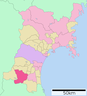
Miyagi 989-0292Webadresse: http://www.city.shiroishi.miyagi.jp Lage Shiroishis in der Präfektur Miyagi 
Shiroishi (jap. 白石市, -shi) ist eine Stadt in der Präfektur Miyagi auf Honshū, der Hauptinsel von Japan.
Inhaltsverzeichnis
Geographie
Shiroishi liegt nördlich von Fukushima und südlich von Sendai. Der Shiroishifluss mit seinen 69,7 km Gesamtlänge ist der bedeutendste Fluss im Stadtgebiet.
Geschichte
- 1602 Katakura Kojūrō, ein Lehnsmann von Date Masamune bekam das Schloss von Shiroishi und die Verwaltung der Umgebung. In seiner Herrschaft entwickelte er die Infrastruktur der Stadt.
- 1954 schloss sich Shiroishi mit 10 umliegenden Dörfern zusammen.
- 1957 wurde auch das Dorf Obara mit seinen heißen Quellen eingemeindet.
Verkehr
- Straße:
- Tōhoku-Autobahn
- Nationalstraße 4, nach Tokio bzw. Aomori
- Nationalstraße 113,457
- Zug:
- JR Tōhoku-Shinkansen: Bahnhof Shiroishi-Zaō
- JR Tōhoku-Hauptlinie
Sehenswürdigkeiten
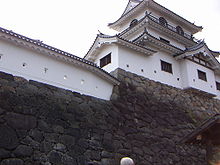
- Burg Shiroishi
Angrenzende Städte und Gemeinden
Städtepartnerschaft
- 1983 Noboribetsu, Hokkaidō, Japan
- 1991 Ebina, Kanagawa, Japan
- 1994 Hurstville City, Australien
Weblinks
 Commons: Shiroishi – Sammlung von Bildern, Videos und AudiodateienGemeinden und Landkreise in der Präfektur Miyagi
Kreisfreie Städte (shi): Higashimatsushima | Ishinomaki | Iwanuma | Kakuda | Kesennuma | Kurihara | Natori | Ōsaki | Sendai (Verwaltungsssitz) | Shiogama | Shiroishi | Tagajō | Tome
Igu-gun: Marumori | Kami-gun: Kami | Shikama | Katta-gun: Shichikashuku | Zaō | Kurokawa-gun: Ōhira | Ōsato | Taiwa | Tomiya | Miyagi-gun: Matsushima | Rifu | Shichigahama | Motoyoshi-gun: Minamisanriku | Oshika-gun: Onagawa | Shibata-gun: Kawasaki | Murata | Ōgawara | Shibata | Toda-gun: Misato | Wakuya | Watari-gun: Watari | Yamamoto
Wikimedia Foundation.
Schlagen Sie auch in anderen Wörterbüchern nach:
Shiroishi, Miyagi — Shiroishi (白石市; shi) is a city located in Miyagi, Japan.As of 2003, the city has an estimated population of 40,209 and the density of 140.36 persons per km². The total area is 286.47 km².The city was founded on April 1, 1954.Notable Location… … Wikipedia
Shiroishi Station (Miyagi) — Shiroishi Station (白石駅) is a JR East railway station located in Shiroishi, Miyagi Prefecture, Japan.Line* Tōhoku Main Lineurrounding areaHistory*December 15, 1887: Station begins operation. *October 25, 1970: Sister station relationship with JR… … Wikipedia
Shiroishi — may refer to:* Shiroishi, Miyagi * Shiroishi, Saga … Wikipedia
Shiroishi-Zaō Station — (白石蔵王駅) is a JR East railway station located in Shiroishi, Miyagi Prefecture, Japan.Line* Tōhoku Shinkansenurrounding areaHistoryJune 23, 1982: Station is opened.Adjacent stations … Wikipedia
Shiroishi — 白石市 Shiroishi shi … Deutsch Wikipedia
Shiroishi Castle — Infobox Military Structure name=Shiroishi Castle 白石城 partof= location=Shiroishi, Miyagi, Japan caption=Shiroishi Castle s tower type=Japanese castle built=Kamakura era builder=Shiroishi clan materials=wood, stone height= used=Kamakura era through … Wikipedia
Miyagi Prefecture — Japanese transcription(s) – Japanese 宮城県 – Rōmaji Miyagi ken … Wikipedia
Shiroishi — shi (白石市) Onsen Obara à Shiroishi Administration Pays Japon Région Tōhoku Pré … Wikipédia en Français
Shiroishi Station — is the name of multiple train stations in Japan.* Shiroishi Station (Kumamoto) (白石駅) in Kumamoto Prefecture * Shiroishi Station (Miyagi) (白石駅) in Miyagi Prefecture * Shiroishi Station (JR Hokkaidō) (白石駅) JR train station in Sapporo, Hokkaidō *… … Wikipedia
Miyagi District, Miyagi — Miyagi District (宮城郡, Miyagi gun?) is a district located in past Mutsu Province and today s Miyagi, Japan. The name of the prefecture was from this district. The original territory was east west long from Ōu Mountains to Pacific Ocean, including… … Wikipedia


