- Sodegaura
-
Sodegaura-shi
袖ヶ浦市Geographische Lage in Japan Region: Kantō Präfektur: Chiba Koordinaten: 35° 26′ N, 139° 57′ O35.429986111111139.95444166667Koordinaten: 35° 25′ 48″ N, 139° 57′ 16″ O Basisdaten Fläche: 94,92 km² Einwohner: Gemeindeschlüssel: 12229-7 Symbole Baum: Shii-Castanopsis Blume: Lilium auratum Vogel: Japanbuschsänger Lied: Hikari no Kosumosu Rathaus Adresse: Sodegaura City Hall
1-1, Sakado-Ichiba
Sodegaura-shi
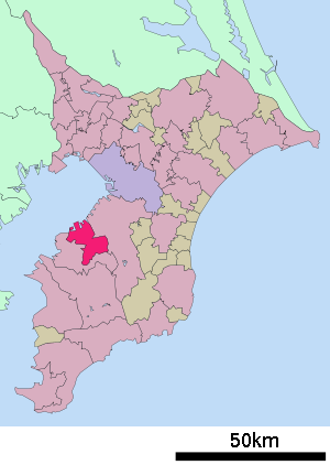
Chiba 299-0292Webadresse: http://www.city.sodegaura.chiba.jp Lage Sodegauras in der Präfektur Chiba Sodegaura (jap. 袖ヶ浦市, -shi) ist eine Stadt der Präfektur Chiba im Osten von Honshu, der Hauptinsel Japans.
Inhaltsverzeichnis
Geographie
Die Stadt liegt südöstlich von Tokio auf der Bōsō-Halbinsel an der Bucht von Tokio.
Geschichte
Sodegaura erhielt am 1. April 1991 das Stadtrecht.
Verkehr
- Straße:
- Tateyama-Autobahn
- Nationalstraße 16
- Nationalstraßen 409, 410
- Zug:
Angrenzende Städte und Gemeinden
Weblinks
Commons: Sodegaura – Sammlung von Bildern, Videos und AudiodateienGemeinden und Landkreise in der Präfektur ChibaKreisfreie Städte (shi): Abiko | Asahi | Chiba (Verwaltungssitz) | Chōshi | Funabashi | Futtsu | Ichihara | Ichikawa | Inzai | Isumi | Kamagaya | Kamogawa | Kashiwa | Katori | Katsuura | Kimitsu | Kisarazu | Matsudo | Minamibōsō | Mobara | Nagareyama | Narashino | Narita | Noda | Sakura | Sammu | Shiroi | Sodegaura | Sōsa | Tateyama | Tomisato | Tōgane | Urayasu | Yachimata | Yachiyo | Yotsukaidō
Awa-gun: Kyonan | Chōsei-gun: Chōnan | Chōsei | Ichinomiya | Mutsuzawa | Nagara | Shirako | Imba-gun: Sakae | Shisui | Isumi-gun: Onjuku | Ōtaki | Katori-gun: Kōzaki | Tako | Tōnoshō | Sambu-gun: Kujūkuri | Ōami-Shirasato | Shibayama | Yokoshiba-Hikari
Wikimedia Foundation.
Schlagen Sie auch in anderen Wörterbüchern nach:
Sodegaura — shi (袖ヶ浦市) Mairie Administration Pays Japon Région Kantō Préfecture … Wikipédia en Français
Sodegaura (Chiba) — 袖ヶ浦市 Sodegaura … Wikipedia Español
Sodegaura, Chiba — nihongo|Sodegaura|袖ヶ浦市|Sodegaura shi is a city located in Chiba, Japan.As of 2003, the city has an estimated population of 59,259 and the density of 624.30 persons per km². The total area is 94.92 km².The city was founded on April 1, 1991.The… … Wikipedia
Nagaura Station (Chiba) — Nagaura Station 長浦駅 Nagaura Station Location Prefecture Chiba … Wikipedia
Kimitsu District, Chiba — Kimitsu (君津郡; gun) was a district in Japan. The district was dissolved April 1, 1991 when the town of Sodegaura gained city status.The cities of Kisarazu, Futtsu, Kimitsu, and Sodegaura cover the entire district.AreaThe district areas are… … Wikipedia
Uchibō Line — The Nihongo|Uchibō Line|内房線|Uchibō sen is a railway line operated by the East Japan Railway Company (JR East) along Tokyo Bay, on the Western shore of the Bōsō Peninsula. It runs from Soga Station in Chiba to Awa Kamogawa Station in Kamogawa,… … Wikipedia
Nozomi Hiroyama — Personal information Full name … Wikipedia
Chiba Prefectural Board of Education — is a department of the Chiba Prefecture in Japan. The board supervises elementary and middle schools operated by other school districts and directly operates public high schools. Contents 1 Schools directly operated by the prefecture 1.1 High… … Wikipedia
Chiba Prefecture — Japanese transcription(s) Japanese 千葉県 Rōmaji Chiba ken … Wikipedia
List of dissolved districts of Japan — A district of Japan is dissolved when all towns or villages in the district become cities or are merged into the city. The following is a list of dissolved districts of Japan.The date shown is the day the district was dissolved i.e. the district… … Wikipedia
- Straße: