- Isumi
-
Isumi-shi
いすみ市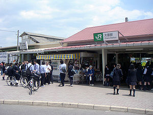
Geographische Lage in Japan 

Region: Kantō Präfektur: Chiba Koordinaten: 35° 15′ N, 140° 23′ O35.253911111111140.38507222222Koordinaten: 35° 15′ 14″ N, 140° 23′ 6″ O Basisdaten Fläche: 157,50 km² Einwohner: 40.592
(1. Juli 2011)Bevölkerungsdichte: 258 Einwohner je km² Gemeindeschlüssel: 298-8501 Rathaus Adresse: Isumi City Hall
7400-1, Ōhara
Isumi-shi
Chiba 298-8501Webadresse: http://www.city.isumi.lg.jp Lage Isumis in der Präfektur Chiba 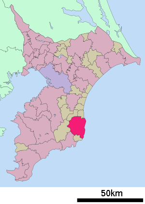
Isumi (jap. いすみ市, -shi) ist eine Stadt der Präfektur Chiba im Osten von Honshu, der Hauptinsel von Japan.
Inhaltsverzeichnis
Geographie
Die Stadt liegt östlich von Tokio auf der Halbinsel Bōsō am Pazifik.
Geschichte
Die Stadt Isumi entstand am 5. Dezember 2005 aus dem Zusammenschluss der Gemeinden Isumi (夷隅町, -machi), Misaki (岬町, -machi) und Ōhara (大原町, -machi) im Landkreis Isumi.
Verkehr
- Straße:
- Nationalstraßen 128, 465
- Zug:
Städtepartnerschaften
 Duluth (Minnesota), seit 1990
Angrenzende Städte und Gemeinden
Weblinks
 Commons: Isumi – Sammlung von Bildern, Videos und Audiodateien
 Gemeinden und Landkreise in der Präfektur Chiba
Kreisfreie Städte (shi): Abiko | Asahi | Chiba (Verwaltungssitz) | Chōshi | Funabashi | Futtsu | Ichihara | Ichikawa | Inzai | Isumi | Kamagaya | Kamogawa | Kashiwa | Katori | Katsuura | Kimitsu | Kisarazu | Matsudo | Minamibōsō | Mobara | Nagareyama | Narashino | Narita | Noda | Sakura | Sammu | Shiroi | Sodegaura | Sōsa | Tateyama | Tomisato | Tōgane | Urayasu | Yachimata | Yachiyo | Yotsukaidō
Awa-gun: Kyonan | Chōsei-gun: Chōnan | Chōsei | Ichinomiya | Mutsuzawa | Nagara | Shirako | Imba-gun: Sakae | Shisui | Isumi-gun: Onjuku | Ōtaki | Katori-gun: Kōzaki | Tako | Tōnoshō | Sambu-gun: Kujūkuri | Ōami-Shirasato | Shibayama | Yokoshiba-Hikari
Wikimedia Foundation.
Schlagen Sie auch in anderen Wörterbüchern nach:
Isumi — shi (いすみ市) Gare Kazusaazuma aux abords de la ville Administration Pays Japon Région Kantō … Wikipédia en Français
Isumi District, Chiba — Isumi (夷隅郡; gun) is a district located in Chiba, Japan.As of 2003, the district has an estimated population of 61,956 and a density of 198.42 persons per km². The total area is 312.25 km². Towns and villages *Onjuku *Ōtaki Mergers On December 5,… … Wikipedia
Isumi (Chiba) — いすみ市 Isumi … Wikipedia Español
Isumi, Chiba — nihongo|Isumi|いすみ市|Isumi shi is a city in Chiba Prefecture, Japan.The city emerged on December 5, 2005 when the town of Isumi, Misaki and Ohara from Isumi District merged to form the city of Isumi.As of 2003, the former town had an estimated… … Wikipedia
Isumi Line — Nihongo|Isumi Line|いすみ線|Isumi sen is a railway line operated by the Isumi Railroad, extending through the middle of the Bōsō Peninsula. It runs from Ōhara in Isumi, where it connects with the Sotobō Line, to Kazusa Nakano in Ŏtaki, where it… … Wikipedia
Isumi-gun — Admin ASC 2 Code Orig. name Isumi gun Country and Admin Code JP.04.2112557 JP … World countries Adminstrative division ASC I-II
Isumi-shi — Admin ASC 2 Code Orig. name Isumi shi Country and Admin Code JP.04.7465524 JP … World countries Adminstrative division ASC I-II
District d'Isumi — 35°15′N 140°12′E / 35.25, 140.2 … Wikipédia en Français
List of Hayate the Combat Butler characters — This article lists the characters from the Japanese manga and anime series Hayate the Combat Butler. Contents 1 Ayasaki household 2 Sanzenin household 2.1 M.H.E. (Mikado Hyper Energy) … Wikipedia
Ōhara Station (Chiba) — Coordinates: 35°15′3.5″N 140°23′27.1″E / 35.250972°N 140.390861°E / 35.250972; 140.390861 … Wikipedia
- Straße:
Isumi


18+
© Academic, 2000-2026
- Kontaktieren Sie uns: Unterstützung, Werbung
Wörterbücher Export, schritte mit PHP, Joomla, Drupal, WordPress, MODx.