- Tomisato
-
Tomisato-shi
富里市

Geographische Lage in Japan Region: Kantō Präfektur: Chiba Koordinaten: 35° 44′ N, 140° 21′ O35.727033333333140.34284166667Koordinaten: 35° 43′ 37″ N, 140° 20′ 34″ O Basisdaten Fläche: 53,91 km² Einwohner: 50.436
(1. Juli 2011)Bevölkerungsdichte: 936 Einwohner je km² Gemeindeschlüssel: 12233-5 Symbole Baum: Prunus jamasakura Blume: Feuersalbei Rathaus Adresse: Tomisato City Hall
652-1, Nanae
Tomisato-shi
Chiba 286-0292Webadresse: http://www.city.tomisato.chiba.jp Lage Tomisatos in der Präfektur Chiba 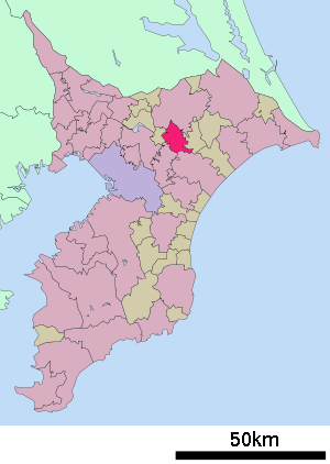
Tomisato (jap. 富里市, -shi) ist eine Stadt der Präfektur Chiba im Osten von Honshū, der Hauptinsel von Japan.
Inhaltsverzeichnis
Geographie
Tomisato liegt südlich von Narita und nördlich von Chiba.
Verkehr
Angrenzende Städte und Gemeinden
Weblink

Kreisfreie Städte (shi): Abiko | Asahi | Chiba (Verwaltungssitz) | Chōshi | Funabashi | Futtsu | Ichihara | Ichikawa | Inzai | Isumi | Kamagaya | Kamogawa | Kashiwa | Katori | Katsuura | Kimitsu | Kisarazu | Matsudo | Minamibōsō | Mobara | Nagareyama | Narashino | Narita | Noda | Sakura | Sammu | Shiroi | Sodegaura | Sōsa | Tateyama | Tomisato | Tōgane | Urayasu | Yachimata | Yachiyo | Yotsukaidō
Awa-gun: Kyonan | Chōsei-gun: Chōnan | Chōsei | Ichinomiya | Mutsuzawa | Nagara | Shirako | Imba-gun: Sakae | Shisui | Isumi-gun: Onjuku | Ōtaki | Katori-gun: Kōzaki | Tako | Tōnoshō | Sambu-gun: Kujūkuri | Ōami-Shirasato | Shibayama | Yokoshiba-Hikari


Wikimedia Foundation.