- Stoke Newington
-
London Borough of Hackney 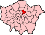
Lage in Greater LondonStatus London Borough Region Greater London Verwaltungssitz Hackney Fläche 19,06 km² (349.) Einwohner (2007) 209.700 (64.) ONS-Code 00AM Website www.hackney.gov.uk London Borough of Hackney [ˈhækni] ist ein Stadtbezirk von London und liegt nordöstlich des Stadtzentrums. Bei der Gründung von Greater London im Jahr 1965 wurde er aus den Bezirken Hackney, Shoreditch und Stoke Newington der ehemaligen County of London gebildet.
Hackney ist einer der ärmsten Stadtbezirke von London und weist mit "Manor House" nur einen einzigen U-Bahn-Anschluss auf. Durch die geplante Verlängerung der East London Line erhofft man sich jedoch eine Verbesserung der Situation. Die Bevölkerung setzt sich zusammen aus 59,46 % Weißen, 24,7 % Schwarzen, 8,6 % Südasiaten und 1,2 % Chinesen. Eine Partnerschaft besteht zum Landkreis Göttingen, zur Stadt Haifa in Israel sowie zu Bridgetown, der Hauptstadt von Barbados.
Stadtteile
- Dalston
- De Beauvoir Town
- Hackney Downs
- Hackney Central
- Hackney Marshes
- Hackney Wick
- Haggerston
- Homerton
- Hoxton
- Kingston
- Lea Bridge
- London Fields
- Lower Clapton
- Shacklewell
- Shoreditch
- South Hackney
- Stamford Hill
- Stoke Newington
- Upper Clapton
Persönlichkeiten
 Hoxton Street in Shoreditch/Hackney
- Marc Bolan - Rockmusiker (Sänger und Gitarrist bei T. Rex)
- Nicko McBrain - Rockmusiker (Schlagzeuger bei Iron Maiden)
- John Berger - Schriftsteller
- Gary Brooker - Rockmusiker (Procol Harum)
- Edward Theodore Compton - Alpenmaler und Bergsteiger
- Edmond Halley - Astronom
- Shaka Hislop - trinidadischer Fußballspieler
- Klashnekoff - Rapper
- Leona Lewis - Sängerin
- Jean Marsh - Schauspielerin und Drehbuchautorin
- Harold Pinter - Theaterautor und Regisseur
- James Parkinson - Arzt und Paläontologe
- Adrian Smith - Rockmusiker (Gitarrist bei Iron Maiden)
- Charles Sotheran - Journalist, Politiker und Theosoph
- Sir Alan Michael Sugar - Unternehmer
- Mary Wollstonecraft - Schriftstellerin und Frauenrechtlerin
- Eric Bristow, MBE - Dartspieler
- Auf dem Friedhof von Hackney liegt der Priester und Gründer der Heilsarmee William Booth begraben.
Weblinks
51.533333333333-0.083333333333343Koordinaten: 51° 32′ N, 0° 5′ W
Stadtbezirke von LondonBarking and Dagenham | Barnet | Bexley | Brent | Bromley | Camden | City of London | City of Westminster | Croydon | Ealing | Enfield | Greenwich | Hackney | Hammersmith and Fulham | Haringey | Harrow | Havering | Hillingdon | Hounslow | Islington | Kensington and Chelsea | Kingston | Lambeth | Lewisham | Merton | Newham | Redbridge | Richmond | Southwark | Sutton | Tower Hamlets | Waltham Forest | Wandsworth
Sonstige Einteilung: Greater London | Inner London | Outer London | County of London


Wikimedia Foundation.