Candlemas Island

Candlemas Island

Vorlage:Infobox Insel/Wartung/Bild fehlt

Candlemas Island
Gewässer Atlantischer Ozean
Inselgruppe Südliche Sandwichinseln
Geographische Lage 57° 4′ 46″ S, 26° 40′ 39″ W-57.079444444444-26.6775550Koordinaten: 57° 4′ 46″ S, 26° 40′ 39″ W
Lage von Candlemas Island
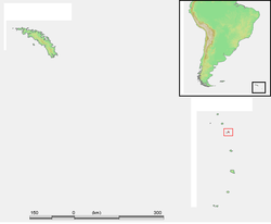
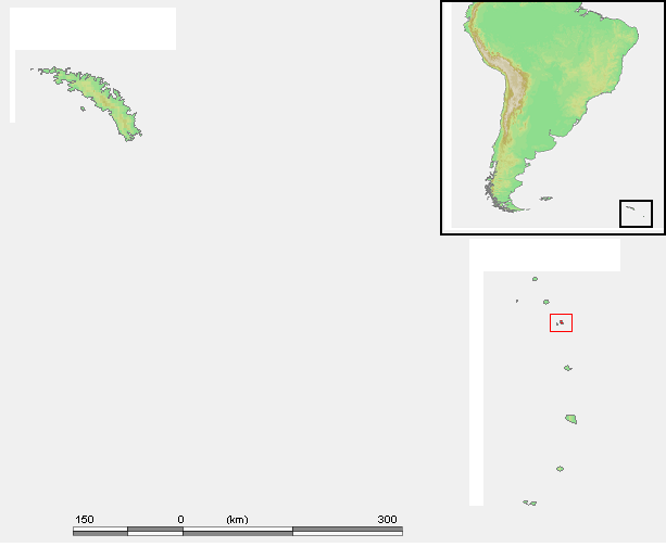
Länge 5,9 km
Breite 3,7 km
Fläche ca. 12 km²dep1
Höchste Erhebung 550 m
Einwohner (unbewohnt)

Candlemas Island ist eine kleine, unbewohnte Insel des im südlichen Atlantischen Ozean gelegenen britischen Überseegebietes von Südgeorgien und den Südlichen Sandwichinseln.

Das in den Südlichen Sandwichinseln gelegene Eiland bildet mit der nur 4,5 km südwestlich gelegenen Nachbarinsel Vindication die Gruppe der Candlemasinseln. Candlemas Island weist eine Länge von etwa 5,9 km sowie eine Breite von 3,7 km auf.

Die namensgebende Hauptinsel Candlemas Island wurde 1775 vom britischen Seefahrer James Cook entdeckt. Er fand damals vermutlich das vor, was sich noch bis Ende der 50er-Jahre des 20. Jahrhunderts zeigte: Im Norden der Insel einen unermüdlich aktiven Stratovulkan mit Feuer und Lavaaktivitäten. Den Namen vergab Cook nach dem Tag der Erstsichtung, dem 2. Februar 1775, dem Lichtmeßtag, engl. Candlemas.[1]

  1. Henze, Dietmar: Enzyklopädie der Entdecker und Erforscher der Erde, Bd. 1; Graz 1978, S. 694

Weblinks


Wikimedia Foundation.

Игры ⚽ Нужно сделать НИР?

Schlagen Sie auch in anderen Wörterbüchern nach:

  • Candlemas Island — is a small uninhabited island of the Candlemas Islands in the South Sandwich Islands. It lies about two miles from Vindication Island, separated by the Nelson Channel.On the northwest flank of the island is an active stratovolcano, Lucifer Hill,… …   Wikipedia

  • Candlemas Islands — Candlemasinseln Gewässer Südatlantik Archipel Südliche Sandwichinseln Anzahl der Inseln 2 Hauptinsel Candlemas Island Gesamtfläche …   Deutsch Wikipedia

  • Candlemas Islands — The Candlemas Islands (Spanish: Islas Candelaria) are a group of small uninhabited islands lying at the northern end of the South Sandwich Islands, 23 miles southeast of Visokoi Island. They consist of Candlemas Island itself… …   Wikipedia

  • Vindication Island — NASA Bild von Vindication Island Gewässer Atlantischer Ozean …   Deutsch Wikipedia

  • Bristol Island (Südsandwichinseln) — Vorlage:Infobox Insel/Wartung/Bild fehlt Bristol Island Gewässer Atlantischer Ozean Inselgruppe Südliche Sandwichinseln Geographische Lage …   Deutsch Wikipedia

  • Cooper Island (Südgeorgien) — w1 Cooper Island Karte von Südgeorgien, auf der im Südosten Cooper Island zu erkennen ist Gewässer At …   Deutsch Wikipedia

  • Grass Island (Südgeorgien) — w1 Grass Island Stromness Bay: Grass Island in der Mitte. Gewässer Atlantischer Ozean Geog …   Deutsch Wikipedia

  • Ile Candlemas — Île Candlemas Île Candlemas Géographie Pays  Royaume Uni Archipel Îles Sandwich du Sud Localisation …   Wikipédia en Français

  • Île Candlemas — Géographie Pays  Royaume Uni Archipel Îles Sandwich du Sud …   Wikipédia en Français

  • Îles Candlemas — Île Candlemas Île Candlemas Géographie Pays  Royaume Uni Archipel Îles Sandwich du Sud Localisation …   Wikipédia en Français

Share the article and excerpts

Direct link
Do a right-click on the link above
and select “Copy Link”