- Montagu Island
-
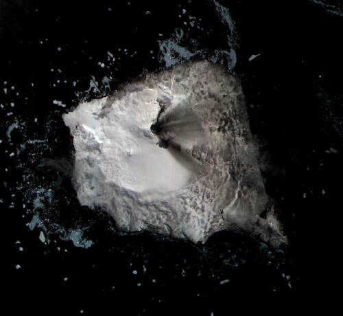
Montagu Island Satellitenbild von Montagu Island
Gewässer Atlantischer Ozean Inselgruppe Südliche Sandwichinseln Geographische Lage 58° 26′ S, 26° 20′ W-58.434722222222-26.3388888888891370Koordinaten: 58° 26′ S, 26° 20′ W 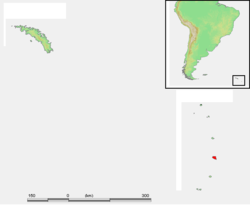
Länge 12 km Breite 10 km Fläche 110 km² Höchste Erhebung Mount Belinda
1.370 mEinwohner (unbewohnt) Montagu Island (spanisch Isla Jorge) ist mit etwa 110 km² Fläche die größte der im subantarktischen Südatlantik gelegenen Südsandwichinseln. Die Insel zählt politisch zum Britischen Überseegebiet „Südgeorgien und die Südlichen Sandwichinseln“, wird aber auch von Argentinien beansprucht.
Inhaltsverzeichnis
Geographie
Die unbewohnte Vulkaninsel liegt zentral innerhalb des Inselbogens der Südsandwichinseln, etwa 50 km südlich von Saunders Island und 50 km nördlich von Bristol Island. Montagu Island hat eine Ausdehnung von ca. 12 × 10 km, wobei über 90% ihrer Fläche permanent mit Eis bedeckt sind. Der Schildvulkan Mount Belinda ist mit seiner Höhe von 1370 m über dem Meer der bemerkenswerteste geographische Aspekt der vegetationslosen Insel.
Im November 2005 deckten Satellitenbilder auf, dass eine Eruption von Mount Belinda einen rund 90 m breiten Lavastrom erzeugt hatte, der sich bis an die Nordküste der Insel bewegte. Dieses Ereignis vergrößerte die Fläche der Insel um ca. 0,2 km², und lieferte eine der ersten wissenschaftlichen Beobachtungen einer vulkanischen Eruption unter einer Eisdecke.
Geschichte
Entdeckt wurde Montagu Island am 1. Februar 1775 vom englischen Seefahrer James Cook, der sie nach John Montagu, damals First Lord of the British Admiralty, Cape Montagu benannte, da er annahm, es handele sich um die Spitze eines größeren Landes. Erst Fabian von Bellingshausen stellte im Januar 1820 den Inselcharakter fest. Die erste bekannte Landung auf Montagu Island erfolgte 1908 durch den norwegischen Walfänger Carl Anton Larsen.[1]
Weblinks
- Montagu Island im Global Volcanism Program der Smithsonian Institution (englisch)
Einzelnachweise
- ↑ William James Mills: Exploring Polar Frontiers – A Historical Encyclopedia, Bd. 1, ABC-CLIO, 2003, ISBN 1-57607-422-6, S. 430 (englisch)

Südgeorgien: Annenkov | Bird | Clerke Rocks | Cooper | Grass | Kupriyanov | Pickersgill | Shag Rocks | Südgeorgien | Willis | Welcome
Südliche Sandwichinseln: Bellingshausen | Bristol | Candlemas | Cook | Leskov | Montagu | Morrell (Thule) | Saunders | Vindication | Visokoi | Zavodovski
Wikimedia Foundation.
Schlagen Sie auch in anderen Wörterbüchern nach:
Montagu Island — … Wikipedia
Montagu — ist der Familienname folgender Personen: Ashley Montagu (1905–1999), britisch US amerikanischer Anthropologe Edward Montagu, 1. Earl of Sandwich (1625–1672), britischer Admiral und Politiker Edward Douglas Scott Montagu, 3. Baron Montagu of… … Deutsch Wikipedia
Montagu — Not to be confused with Montague. Montagu may refer to: Contents 1 People with the surname 2 Titles of nobility 3 … Wikipedia
Montagu Love — Born Harry Montague Love 15 March 1877(1877 03 15) Portsmouth, Hampshire, England, UK … Wikipedia
Montagu Burrows — (27 October 1819, Hadley, England 10 July 1905, Oxford) was an officer in the Royal Navy and subsequently the first Chichele Professor of Modern History at Oxford University. He was probably the very first academic to lecture on naval history at… … Wikipedia
Montagu Love — Données clés Nom de naissance Harry Montagu Love Naissance … Wikipédia en Français
Bristol Island (Südsandwichinseln) — Vorlage:Infobox Insel/Wartung/Bild fehlt Bristol Island Gewässer Atlantischer Ozean Inselgruppe Südliche Sandwichinseln Geographische Lage … Deutsch Wikipedia
Bristol Island — NASA Bild von Bristol Island Gewässer Atlantischer Ozean Inselgrup … Deutsch Wikipedia
Cooper Island (Südgeorgien) — w1 Cooper Island Karte von Südgeorgien, auf der im Südosten Cooper Island zu erkennen ist Gewässer At … Deutsch Wikipedia
Grass Island (Südgeorgien) — w1 Grass Island Stromness Bay: Grass Island in der Mitte. Gewässer Atlantischer Ozean Geog … Deutsch Wikipedia
Montagu Island

18+
© Academic, 2000-2026
- Kontaktieren Sie uns: Unterstützung, Werbung
Wörterbücher Export, schritte mit PHP, Joomla, Drupal, WordPress, MODx.