- Harrison County (Iowa)
-
Verwaltung US-Bundesstaat: Iowa Verwaltungssitz: Logan Adresse des
Verwaltungssitzes:Harrison County Courthouse
111 North 2nd Avenue
Logan, IA 51546Gründung: 1851 Vorwahl: 001 712 Demographie Einwohner: 14.928 (2010) Bevölkerungsdichte: 8,3 Einwohner/km² Geographie Fläche gesamt: 1.815 km² Wasserfläche: 11 km² Karte 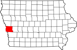
Website: www.harrisoncountyia.org Das Harrison County[1] ist ein County im Bundesstaat Iowa der Vereinigten Staaten von Amerika. Im Jahr 2010 hatte das County 14.928 Einwohner und eine Bevölkerungsdichte von 8,3 Einwohner pro Quadratkilometer. Der Verwaltungssitz (County Seat) ist Logan, benannt nach General John A. Logan.
Inhaltsverzeichnis
Geografie
Das County liegt im Westen von Iowa, grenzt an Nebraska, wobei die Grenze durch den Missouri River gebildet wird und hat eine Fläche von 1815 Quadratkilometern, wovon 11 Quadratkilometer Wasserfläche sind. Es grenzt in Iowa im Uhrzeigersinn an folgende Countys: Monona County, Crawford County, Shelby County und Pottawattamie County.
Geschichte
Harrison County wurde 1851 gebildet. Benannt wurde es nach dem 9. US-Präsidenten William H. Harrison.
Demografische Daten
Historische Einwohnerzahlen Census Einwohner ± in % 1860 3621 — 1870 8931 100 % 1880 16.649 90 % 1890 21.356 30 % 1900 25.597 20 % 1910 23.162 -10 % 1920 24.488 6 % 1930 24.897 2 % 1940 22.767 -9 % 1950 19.560 -10 % 1960 17.600 -10 % 1970 16.240 -8 % 1980 16.348 0,7 % 1990 14.730 -10 % 2000 15.666 6 % 2010 14.928 -5 % Vor 1900[2] Nach der Volkszählung im Jahr 2000 lebten im Harrison County 15.666 Menschen in 6.115 Haushalten und 4.304 Familien. Die Bevölkerungsdichte betrug 9 Einwohner pro Quadratkilometer. Ethnisch betrachtet setzte sich die Bevölkerung zusammen aus 98,69 Prozent Weißen, 0,08 Prozent Afroamerikanern, 0,22 Prozent amerikanischen Ureinwohnern, 0,16 Prozent Asiaten, 0,01 Prozent Bewohnern aus dem pazifischen Inselraum und 0,20 Prozent aus anderen ethnischen Gruppen; 0,64 Prozent stammten von zwei oder mehr Ethnien ab. 0,72 Prozent der Bevölkerung waren spanischer oder lateinamerikanischer Abstammung, die verschiedenen der genannten Gruppen angehörten.
Von den 6.115 Haushalten hatten 32,3 Prozent Kinder und Jugendliche unter 18 Jahre, die bei ihnen lebten. 59,3 Prozent waren verheiratete, zusammenlebende Paare, 7,6 Prozent waren allein erziehende Mütter, 29,6 Prozent waren keine Familien, 26,1 Prozent waren Singlehaushalte und in 13,7 Prozent lebten Menschen im Alter von 65 Jahren oder darüber. Die Durchschnittshaushaltsgröße betrug 2,51 und die durchschnittliche Familiengröße lag bei 3,02 Personen.
Auf das gesamte County bezogen setzte sich die Bevölkerung zusammen aus 26,2 Prozent Einwohnern unter 18 Jahren, 6,8 Prozent zwischen 18 und 24 Jahren, 27,0 Prozent zwischen 25 und 44 Jahren, 22,3 Prozent zwischen 45 und 64 Jahren und 17,7 Prozent waren 65 Jahre oder darüber. Das Durchschnittsalter betrug 39 Jahre. Auf 100 weibliche Personen kamen statistisch 96,5 männliche Personen. Auf 100 Frauen im Alter von 18 Jahren oder darüber kamen 91,8 Männer.
Das jährliche Durchschnittseinkommen eines Haushalts betrug 38.141 USD, das Durchschnittseinkommen der Familien betrug 44.586 USD. Männer hatten ein Durchschnittseinkommen von 30.000 USD, Frauen 21.663 USD. Das Pro-Kopf-Einkommen betrug 17.662 USD. 5,0 Prozent der Familien und 7,1 Prozent der Bevölkerung lebten unterhalb der Armutsgrenze. [5]
Städte und Gemeinden
- Dunlap
- Little Sioux
- Logan
- Magnolia
- Missouri Valley
- Mo Valley
- Modale
- Mondamin
- Persia
- Pisgah
- Woodbine
Einzelnachweise
- ↑ GNIS-ID: 465231. Abgerufen am 24. Februar 2011 (englisch).
- ↑ U.S. Census Bureau - Census of Population and Housing. Abgerufen am 15. März 2011
- ↑ Auszug aus Census.gov Abgerufen am 16. Februar 2011
- ↑ United States Census 2011 Abgerufen am 24. Februar 2011
- ↑ Harrison County, Iowa, Datenblatt mit den Ergebnissen der Volkszählung im Jahre 2000 bei factfinder.census.gov.
Weblinks
-
 Commons: Harrison County, Iowa – Sammlung von Bildern, Videos und Audiodateien
 - www.city-data.com

Liste der Countys in Iowa
Adair | Adams | Allamakee | Appanoose | Audubon | Benton | Black Hawk | Boone | Bremer | Buchanan | Buena Vista | Butler | Calhoun | Carroll | Cass | Cedar | Cerro Gordo | Cherokee | Chickasaw | Clarke | Clay | Clayton | Clinton | Crawford | Dallas | Davis | Decatur | Delaware | Des Moines | Dickinson | Dubuque | Emmet | Fayette | Floyd | Franklin | Fremont | Greene | Grundy | Guthrie | Hamilton | Hancock | Hardin | Harrison | Henry | Howard | Humboldt | Ida | Iowa | Jackson | Jasper | Jefferson | Johnson | Jones | Keokuk | Kossuth | Lee | Linn | Louisa | Lucas | Lyon | Madison | Mahaska | Marion | Marshall | Mills | Mitchell | Monona | Monroe | Montgomery | Muscatine | O'Brien | Osceola | Page | Palo Alto | Plymouth | Pocahontas | Polk | Pottawattamie | Poweshiek | Ringgold | Sac | Scott | Shelby | Sioux | Story | Tama | Taylor | Union | Van Buren | Wapello | Warren | Washington | Wayne | Webster | Winnebago | Winneshiek | Woodbury | Worth | Wright
Wikimedia Foundation.
Schlagen Sie auch in anderen Wörterbüchern nach:
Harrison County, Iowa — Infobox U.S. County county = Harrison County state = Iowa map size = 225 founded = 1851 seat = Logan area total sq mi =701 area land sq mi =697 area water sq mi =4 area percentage = 0.60% census yr = 2000 pop = 15666 density km2 =9 web =… … Wikipedia
Cincinnati Township, Harrison County, Iowa — Coordinates: 41°35′N 96°00′W / 41.58°N 96.00°W / 41.58; 96.00 … Wikipedia
Harrison County Courthouse — may refer to: Harrison County Courthouse (Iowa), in Logan, Iowa, listed on the National Register of Historic Places (NRHP) Old Harrison County Courthouse (Iowa), in Magnolia, Iowa, listed on the NRHP in Harrison County, Iowa Harrison County… … Wikipedia
Harrison County — is the name of eight counties in the United States: Harrison County, Indiana the Harrison County meteorite of 1859, which landed in Indiana, United States (see meteorite falls) Harrison County, Iowa Harrison County, Kentucky Harrison County,… … Wikipedia
Iowa County (Iowa) — Iowa County Courthouse in Marengo, gelistet im NRHP Nr. 81000247[1] Verwaltung … Deutsch Wikipedia
Harrison County — Es gibt in den Vereinigten Staaten acht Countys mit dem Namen Harrison County: Harrison County (Indiana) Harrison County (Iowa) Harrison County (Kentucky) Harrison County (Mississippi) Harrison County (Missouri) Harrison County (Ohio) Harrison… … Deutsch Wikipedia
Harrison County (Missouri) — Harrison County Courthouse in Bethany Verwaltung US Bundesstaat: Missouri … Deutsch Wikipedia
Harrison County Courthouse — bezeichnet mehrere gleichnamige, im NRHP gelistete, Objekte: Harrison County Courthouse (Iowa), ID Nr. 81000243 Harrison County Courthouse (Kentucky), ID Nr. 74000880 Harrison County Courthouse (Ohio), ID Nr. 74001524 Harrison County Courthouse… … Deutsch Wikipedia
Harrison County, Missouri — Infobox U.S. County county = Harrison County state = Missouri map size = 225 founded = 1845 seat = Bethany area total sq mi =726 area land sq mi =725 area water sq mi =1 area percentage = 0.18% census yr = 2000 pop = 8850 density km2 =5 web =… … Wikipedia
Harrison Township, Adair County, Iowa — Infobox Settlement official name = Harrison Township, Adair County settlement type = Township nickname = motto = imagesize = image caption = image imagesize = image caption = image mapsize = map caption = mapsize1 = map caption1 = subdivision… … Wikipedia
Harrison County (Iowa)

18+
© Academic, 2000-2026
- Kontaktieren Sie uns: Unterstützung, Werbung
Wörterbücher Export, schritte mit PHP, Joomla, Drupal, WordPress, MODx.