- Boone County (Iowa)
-
Verwaltung US-Bundesstaat: Iowa Verwaltungssitz: Boone Adresse des
Verwaltungssitzes:Boone County Courthouse
201 State Street
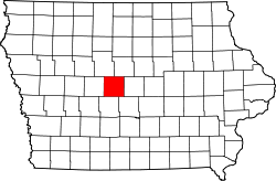
Boone, IA 50036Gründung: Februar 1846 Gebildet aus: Original-County Vorwahl: 001 515 Demographie Einwohner: 26.306 (2010) Bevölkerungsdichte: 17,8 Einwohner/km² Geographie Fläche gesamt: 1.485 km² Wasserfläche: 5 km² Karte Website: www.co.boone.ia.us Das Boone County[2] ist ein County im US-amerikanischen Bundesstaat Iowa. Bei der Volkszählung im Jahr 2010 hatte das County 26.306 Einwohner und eine Bevölkerungsdichte von 17,8 Einwohnern pro Quadratkilometer. Der Verwaltungssitz (County Seat) ist Boone.[3]
Inhaltsverzeichnis
Geografie
Das County liegt etwas westlich des geografischen Zentrums von Iowa und wird vom Des Moines River durchflossen. Das Boone County hat eine Fläche von 1.485 Quadratkilometern, wovon 5 Quadratkilometer Wasserfläche sind. Es grenzt an folgende Countys:
Webster County Hamilton County Greene County 
Story County Dallas County Polk County Geschichte
Das Boone County wurde im Februar 1847 aus als frei bezeichneten - in Wirklichkeit aber von Indianern besiedelten - Territorium gebildet. Benannt wurde es nach Captain (Hauptmann) Nathan Boone, Sohn von Daniel Boone.
Nachdem es zuerst vom Polk County aus verwaltet wurde, beschlossen die Bürger, eine eigene Gerichtsbarkeit einzurichten, eine gesetzgebende Versammlung zu wählen und eine eigene Verwaltung aufzubauen.
Bis 1871 wurde die Gliederung des Countys in 17 Townships und deren heute noch bestehenden Grenzen abgeschlossen.[4]
Nachdem Gerichtsverhandlungen im County zuerst in Privat- oder Schulhäusern abgehalten worden waren, errichtete man 1857 ein neues Gerichtsgebäude. Im Jahre 1868 wurde ein größeres Gebäude errichtet, das heutige Gebäude wurde im Jahr 1918 fertig gestellt.[5]
Demografische Daten
Historische Einwohnerzahlen Census Einwohner ± in % 1850 735 — 1860 4232 500 % 1870 14.584 200 % 1880 20.838 40 % 1890 23.772 10 % 1900 28.200 20 % 1910 27.626 -2 % 1920 29.892 8 % 1930 29.271 -2 % 1940 29.782 2 % 1950 28.139 -6 % 1960 28.037 -0,4 % 1970 26.470 -6 % 1980 26.184 -1 % 1990 25.186 -4 % 2000 26.224 4 % 2010 26.306 0,3 % Vor 1900[6] 1900–1990[7], 2010[8] Nach der Volkszählung im Jahr 2010 lebten im Boone County 26.306 Menschen in 10.914 Haushalten. Die Bevölkerungsdichte betrug 17,8 Einwohner pro Quadratkilometer.
Ethnisch betrachtet setzte sich die Bevölkerung zusammen aus 97,0 Prozent Weißen, 0,8 Prozent Afroamerikanern, 0,3 Prozent amerikanischen Ureinwohnern, 0,3 Prozent Asiaten sowie aus anderen ethnischen Gruppen; 1,0 Prozent stammten von zwei oder mehr Ethnien ab. Unabhängig von der ethnischen Zugehörigkeit waren 1,9 Prozent der Bevölkerung spanischer oder lateinamerikanischer Abstammung.
In den 10.914 Haushalten lebten statistisch je 2,34 Personen.
23,9 Prozent der Bevölkerung waren unter 18 Jahre alt, 60,2 Prozent waren zwischen 18 und 64 und 15,9 Prozent waren 65 Jahre oder älter. 49,8 Prozent der Bevölkerung war weiblich.
Das jährliche Durchschnittseinkommen eines Haushalts lag bei 51.678 USD. Das Pro - Kopf - Einkommen betrug 25.079 USD. 8,2 Prozent der Einwohner lebten unterhalb der Armutsgrenze.[9]
Sonstiges
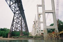
Touristische Ziele sind das Boone County Historical Center in Boone, das Kate Shelley Railroad Museum in Moingona und das Hickory Grove Rural School Museum in der Don Williams Recreation Area im Norden von Ogden.
Städte und Gemeinden
- Beaver
- Berkley
- Boone
- Boxholm
- Fraser
- Luther
- Madrid
- Ogden
- Pilot Mound
- Sheldahl1
- Jordan
- Logansport
- Mackey
- Moingona
- Zenorsville
1 - teilweise im Polk und im Story County
Einzelnachweise
- ↑ Auszug aus dem National Register of Historic Places - Nr. 78001207 Abgerufen am 21. Oktober 2011
- ↑ GNIS-ID: 465197. Abgerufen am 23. Februar 2011 (englisch).
- ↑ National Association of Counties Abgerufen am 21. Oktober 2011
- ↑ Boone County, Iowa - County History Abgerufen am 20. Februar 2011
- ↑ Boone County, Iowa - Courthouse History Abgerufen am 20. Februar 2011
- ↑ U.S. Census Bureau - Census of Population and Housing Abgerufen am 15. März 2011
- ↑ Auszug aus Census.gov Abgerufen am 16. Februar 2011
- ↑ United States Census 2010 Abgerufen am 20. Februar 2011
- ↑ U.S. Census Buero, State & County QuickFacts - Boone County Abgerufen am 21. Oktober 2011
Weblinks
- Offizielle Webseite
- U.S. Census Buero, State & County QuickFacts - Boone County
- Yahoo Bildersuche - Boone County
- www.city-data.com - Boone County
Liste der Countys in Iowa
Adair | Adams | Allamakee | Appanoose | Audubon | Benton | Black Hawk | Boone | Bremer | Buchanan | Buena Vista | Butler | Calhoun | Carroll | Cass | Cedar | Cerro Gordo | Cherokee | Chickasaw | Clarke | Clay | Clayton | Clinton | Crawford | Dallas | Davis | Decatur | Delaware | Des Moines | Dickinson | Dubuque | Emmet | Fayette | Floyd | Franklin | Fremont | Greene | Grundy | Guthrie | Hamilton | Hancock | Hardin | Harrison | Henry | Howard | Humboldt | Ida | Iowa | Jackson | Jasper | Jefferson | Johnson | Jones | Keokuk | Kossuth | Lee | Linn | Louisa | Lucas | Lyon | Madison | Mahaska | Marion | Marshall | Mills | Mitchell | Monona | Monroe | Montgomery | Muscatine | O'Brien | Osceola | Page | Palo Alto | Plymouth | Pocahontas | Polk | Pottawattamie | Poweshiek | Ringgold | Sac | Scott | Shelby | Sioux | Story | Tama | Taylor | Union | Van Buren | Wapello | Warren | Washington | Wayne | Webster | Winnebago | Winneshiek | Woodbury | Worth | Wright
Wikimedia Foundation.


