- Cedar County (Iowa)
-
Verwaltung US-Bundesstaat: Iowa Verwaltungssitz: Tipton Adresse des
Verwaltungssitzes:County Courthouse
400 Cedar Street
Tipton, IA 52772-1748Gründung: 21. Dezember 1837 Gebildet aus: Dubuque County Vorwahl: 001 563 Demographie Einwohner: 18.499 (2010) Bevölkerungsdichte: 12,3 Einwohner/km² Geographie Fläche gesamt: 1.507 km² Wasserfläche: 6 km² Karte 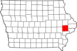
Website: www.cedarcounty.org Das Cedar County[1] ist ein County im US-amerikanischen Bundesstaat Iowa. Bei der Volkszählung im Jahr 2010 hatte das County 18.499 Einwohner und eine Bevölkerungsdichte von 12,3 Einwohnern pro Quadratkilometer. Der Verwaltungssitz (County Seat) ist Tipton.[2]
Inhaltsverzeichnis
Geografie
Das County liegt im Osten von Iowa, ist im Südosten etwa 20 km vom Mississippi River entfernt und hat eine Fläche von 1.507 Quadratkilometern, wovon 6 Quadratkilometer Wasserfläche sind. Es grenzt an folgende Countys:
Linn County Jones County Clinton County Johnson County 
Muscatine County Scott County Geschichte
Das Cedar County wurde am 21. Dezember 1837 aus Teilen des Dubuque County gebildet. Benannt wurde es nach dem Cedar River und ist damit das einzige County in Iowa, das nach einem Baum benannt worden ist.
1840 wurde die Stadt Tipton, der heutige Verwaltungssitz des Countys, gegründet.
Vor dem Sezessionskrieg war die Gegend um West Branch ein wichtiger Stützpunkt der Underground Railroad, ein Netzwerk zur Befreiung von Sklaven aus den Südstaaten.
Der frühere US-Präsident Herbert Hoover (1874-1964) wurde in West Branch im Cedar County geboren.[3]
Öffentliche Einrichtungen
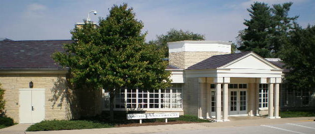
 Herbert Hoover Library
Das County unterhält acht Bibliotheken mit zusammen fast 200.000 Büchern, über 8600 Video- und über 8900 Audio-Dokumenten. Weiterhin gibt es 6 Grundschulen, 4 Mittelschulen und 5 Hochschulen für zusammen rund 3350 Schüler.
Demografische Daten
Historische Einwohnerzahlen Census Einwohner ± in % 1840 1253 — 1850 3941 200 % 1860 12.949 200 % 1870 19.731 50 % 1880 18.936 -4 % 1890 18.253 -4 % 1900 19.371 6 % 1910 17.765 -8 % 1920 17.560 -1 % 1930 16.760 -5 % 1940 16.884 0,7 % 1950 16.910 0,2 % 1960 17.791 5 % 1970 17.655 -0,8 % 1980 18.635 6 % 1990 17.381 -7 % 2000 18.187 5 % 2010 18.499 2 % Vor 1900[4] 1900–1990[5]2000[6] 2010[7] Nach der Volkszählung im Jahr 2010 lebten im Cedar County 18.499 Menschen in 7.558 Haushalten. Die Bevölkerungsdichte betrug 12,3 Einwohner pro Quadratkilometer.
Ethnisch betrachtet setzte sich die Bevölkerung zusammen aus 97,8 Prozent Weißen, 0,3 Prozent Afroamerikanern, 0,2 Prozent amerikanischen Ureinwohnern, 0,5 Prozent Asiaten sowie aus anderen ethnischen Gruppen; 1,1 Prozent stammten von zwei oder mehr Ethnien ab. Unabhängig von der ethnischen Zugehörigkeit waren 1,5 Prozent der Bevölkerung spanischer oder lateinamerikanischer Abstammung.
In den 7.558 Haushalten lebten statistisch je 2,36 Personen.
24,5 Prozent der Bevölkerung waren unter 18 Jahre alt, 58,8 Prozent waren zwischen 18 und 64 und 16,7 Prozent waren 65 Jahre oder älter. 50,5 Prozent der Bevölkerung war weiblich.
Das jährliche Durchschnittseinkommen eines Haushalts lag bei 52.600 USD. Das Pro - Kopf - Einkommen betrug 24.724 USD. 7,9 Prozent der Einwohner lebten unterhalb der Armutsgrenze.[8]
Städte und Gemeinden
- Wilton
- Mechanicsville
- Stanwood
- Tipton
- West Branch2
- Wilton3
1 - teilweise im Muscatine und im Scott County
2 - teilweise im Johnson County
3 - teilweise im Muscatine CountyTownships
- Cass
- Center
- Dayton
- Fairfield
- Farmington
- Fremont
- Gower
- Inland
- Iowa
- Linn
- Massillon
- Pioneer
- Red Oak
- Rochester
- Springdale
- Springfield
- Sugar Creek
Einzelnachweise
- ↑ GNIS-ID: 465205. Abgerufen am 23. Februar 2011 (englisch).
- ↑ National Association of Counties Abgerufen am 8. November 2011
- ↑ Cedar County, Iowa - History Abgerufen am 21. Februar 2011
- ↑ U.S. Census Bureau - Census of Population and Housing Abgerufen am 15. März 2011
- ↑ Auszug aus Census.gov Abgerufen am 16. Februar 2011
- ↑ U.S. Census Buero - Volkszählungsdaten 2000 für das Cedar County, IA Abgerufen am 8. November 2011
- ↑ United States Census 2010 Abgerufen am 21. Februar 2011
- ↑ U.S. Census Buero, State & County QuickFacts - Cedar County Abgerufen am 8. November 2011
Weblinks
-
 Commons: Cedar County, Iowa – Sammlung von Bildern, Videos und Audiodateien
 - Offizielle Webseite
- U.S. Census Buero, State & County QuickFacts - Cedar County
- Yahoo Bildersuche - Cedar County
- www.city-data.com - Cedar County

Liste der Countys in Iowa
Adair | Adams | Allamakee | Appanoose | Audubon | Benton | Black Hawk | Boone | Bremer | Buchanan | Buena Vista | Butler | Calhoun | Carroll | Cass | Cedar | Cerro Gordo | Cherokee | Chickasaw | Clarke | Clay | Clayton | Clinton | Crawford | Dallas | Davis | Decatur | Delaware | Des Moines | Dickinson | Dubuque | Emmet | Fayette | Floyd | Franklin | Fremont | Greene | Grundy | Guthrie | Hamilton | Hancock | Hardin | Harrison | Henry | Howard | Humboldt | Ida | Iowa | Jackson | Jasper | Jefferson | Johnson | Jones | Keokuk | Kossuth | Lee | Linn | Louisa | Lucas | Lyon | Madison | Mahaska | Marion | Marshall | Mills | Mitchell | Monona | Monroe | Montgomery | Muscatine | O'Brien | Osceola | Page | Palo Alto | Plymouth | Pocahontas | Polk | Pottawattamie | Poweshiek | Ringgold | Sac | Scott | Shelby | Sioux | Story | Tama | Taylor | Union | Van Buren | Wapello | Warren | Washington | Wayne | Webster | Winnebago | Winneshiek | Woodbury | Worth | Wright
Wikimedia Foundation.
Schlagen Sie auch in anderen Wörterbüchern nach:
Iowa Township, Cedar County, Iowa — Infobox Settlement official name = Iowa Township, Cedar County settlement type = Township nickname = motto = imagesize = image caption = image imagesize = image caption = image mapsize = map caption = mapsize1 = map caption1 = subdivision type =… … Wikipedia
Cedar County, Iowa — Infobox U.S. County county = Cedar County state = Iowa seallink = map size = 250 founded = 1837 seat = Tipton largest city = 582 square miles (1,507 km²). 580 square miles (1,501 km²) of it is land and 2 square miles (6 km²) of it (0.42% area… … Wikipedia
National Register of Historic Places listings in Cedar County, Iowa — Location of Cedar County in Iowa This is a list of the National Register of Historic Places listings in Cedar County, Iowa. This is intended to be a complete list of the properties and districts on the National Register of Historic Places in… … Wikipedia
Massillon Township, Cedar County, Iowa — Massillon Township, Cedar County Township … Wikipedia
Dayton Township, Cedar County, Iowa — Dayton Township, Cedar County Township … Wikipedia
Center Township, Cedar County, Iowa — Infobox Settlement official name = Center Township, Cedar County settlement type = Township nickname = motto = imagesize = image caption = image imagesize = image caption = image mapsize = map caption = mapsize1 = map caption1 = subdivision type … Wikipedia
Cass Township, Cedar County, Iowa — Infobox Settlement official name = Cass Township, Cedar County settlement type = Township nickname = motto = imagesize = image caption = image imagesize = image caption = image mapsize = map caption = mapsize1 = map caption1 = subdivision type =… … Wikipedia
Fairfield Township, Cedar County, Iowa — Infobox Settlement official name = Fairfield Township, Cedar County settlement type = Township nickname = motto = imagesize = image caption = image imagesize = image caption = image mapsize = map caption = mapsize1 = map caption1 = subdivision… … Wikipedia
Farmington Township, Cedar County, Iowa — Infobox Settlement official name = Farmington Township, Cedar County settlement type = Township nickname = motto = imagesize = image caption = image imagesize = image caption = image mapsize = map caption = mapsize1 = map caption1 = subdivision… … Wikipedia
Fremont Township, Cedar County, Iowa — Infobox Settlement official name = Fremont Township, Cedar County settlement type = Township nickname = motto = imagesize = image caption = image imagesize = image caption = image mapsize = map caption = mapsize1 = map caption1 = subdivision type … Wikipedia
Cedar County (Iowa)


18+
© Academic, 2000-2026
- Kontaktieren Sie uns: Unterstützung, Werbung
Wörterbücher Export, schritte mit PHP, Joomla, Drupal, WordPress, MODx.