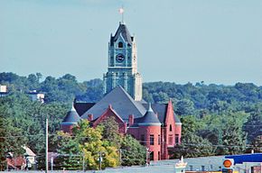
- Clinton County (Iowa)
-
Verwaltung US-Bundesstaat: Iowa Verwaltungssitz: Clinton Adresse des
Verwaltungssitzes:County Administration Building
1900 North 3rd Street
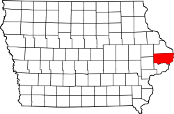
Clinton, IA 52732-2534Gründung: 21. Dezember 1837 Gebildet aus: Dubuque County Vorwahl: 001 563 Demographie Einwohner: 49.116 (2010) Bevölkerungsdichte: 27,3 Einwohner/km² Geographie Fläche gesamt: 1.839 km² Wasserfläche: 39 km² Karte Website: www.clintoncounty-ia.gov Das Clinton County[2] ist ein County im US-amerikanischen Bundesstaat Iowa. Bei der Volkszählung im Jahr 2010 hatte das County 49.116 Einwohner und eine Bevölkerungsdichte von 27,3 Einwohnern pro Quadratkilometer. Der Verwaltungssitz (County Seat) ist Clinton.
Inhaltsverzeichnis
Geografie
Das County liegt im äußersten Osten von Iowa; die Grenze zum benachbarten Bundesstaat Illinois bildet der Mississippi River. Das Clinton County hat eine Fläche von 1.839 Quadratkilometern, wovon 39 Quadratkilometer Wasserfläche sind. Es grenzt an folgende Countys:
Jones County Jackson County Carroll County
(Illinois)
Whiteside County
(Illinois)Cedar County Scott County Rock Island County
(Illinois)Geschichte
Clinton County wurde am 21. Dezember 1837 aus ehemaligen Teilen des Dubuque County und des Wisconsin - Territoriums gebildet.
Benannt wurde es nach DeWitt Clinton (1769-1828), einem Gouverneur von New York und stärkstem Befürworter des Erie-Kanals. Nach ihm wurden auch die Städte De Witt und Clinton benannt.
1835 erbaute Elijah Buell ein Blockhaus für sich und seine Familie und war somit der erste weiße Siedler in diesem Gebiet. 1854 wurde die erste Zeitung herausgegeben und 1858 eröffnete das Lyons Female College, das erste College für Mädchen, seine Pforten. Die damaligen Kosten beliefen sich auf 175 Dollar pro Jahr und Kind.
Das Clinton County ist das einzige in Iowa, das in seiner Geschichte drei verschiedene Bezirkshauptstädte hatte: Camanche, De Witt und Clinton.
Demografische Daten
Historische Einwohnerzahlen Census Einwohner ± in % 1840 821 — 1850 2822 200 % 1860 18.938 600 % 1870 35.357 90 % 1880 36.763 4 % 1890 41.199 10 % 1900 43.832 6 % 1910 45.394 4 % 1920 43.371 -4 % 1930 44.377 2 % 1940 44.722 0,8 % 1950 49.664 10 % 1960 55.060 10 % 1970 56.749 3 % 1980 57.122 0,7 % 1990 51.040 -10 % 2000 50.149 -2 % 2010 49.116 -2 % Vor 1900[3] 1900–1990[4] 2000[5] 2010[6] Nach der Volkszählung im Jahr 2010 lebten im Clinton County 49.116 Menschen in 20.677 Haushalten. Die Bevölkerungsdichte betrug 27,3 Einwohner pro Quadratkilometer.
Ethnisch betrachtet setzte sich die Bevölkerung zusammen aus 94,0 Prozent Weißen, 2,6 Prozent Afroamerikanern, 0,2 Prozent amerikanischen Ureinwohnern, 0,6 Prozent Asiaten sowie aus anderen ethnischen Gruppen; 1,8 Prozent stammten von zwei oder mehr Ethnien ab. Unabhängig von der ethnischen Zugehörigkeit waren 2,5 Prozent der Bevölkerung spanischer oder lateinamerikanischer Abstammung.
In den 20.677 Haushalten lebten statistisch je 2,33 Personen.
23,6 Prozent der Bevölkerung waren unter 18 Jahre alt, 59,6 Prozent waren zwischen 18 und 64 und 16,8 Prozent waren 65 Jahre oder älter. 50,8 Prozent der Bevölkerung war weiblich.
Das jährliche Durchschnittseinkommen eines Haushalts lag bei 47.020 USD. Das Pro - Kopf - Einkommen betrug 23.040 USD. 11,9 Prozent der Einwohner lebten unterhalb der Armutsgrenze.[7]
Städte und Gemeinden
- Andover
- Calamus
- Camanche
- Charlotte
- Clinton
- Delmar
- DeWitt
- Goose Lake
- Grand Mound
- Lost Nation
- Low Moor
- Maquoketa1
- Toronto
- Welton
- Bryant
- Elvira
- Elwood
- Folletts
- Teeds Grove
1 - teilweise im Jackson County
Einzelnachweise
- ↑ Auszug aus dem National Register of Historic Places Abgerufen am 13. März 2011
- ↑ GNIS-ID: 465211. Abgerufen am 23. Februar 2011 (englisch).
- ↑ U.S. Census Bureau - Census of Population and Housing Abgerufen am 15. März 2011
- ↑ Auszug aus Census.gov Abgerufen am 16. Februar 2011
- ↑ U.S. Census Buero - Volkszählungsdaten 2000 für das Clinton County, IA Abgerufen am 17. November 2011
- ↑ United States Census 2010 Abgerufen am 17. November 2011
- ↑ U.S. Census Buero, State & County QuickFacts - Clinton County Abgerufen am 17. November 2011
Weblinks
-
 Commons: Clinton County, Iowa – Sammlung von Bildern, Videos und Audiodateien
 - Offizielle Webseite
- U.S. Census Buero, State & County QuickFacts - Clinton County
- Yahoo Bildersuche - Clinton County
- www.city-data.com - Clinton County
Liste der Countys in Iowa
Adair | Adams | Allamakee | Appanoose | Audubon | Benton | Black Hawk | Boone | Bremer | Buchanan | Buena Vista | Butler | Calhoun | Carroll | Cass | Cedar | Cerro Gordo | Cherokee | Chickasaw | Clarke | Clay | Clayton | Clinton | Crawford | Dallas | Davis | Decatur | Delaware | Des Moines | Dickinson | Dubuque | Emmet | Fayette | Floyd | Franklin | Fremont | Greene | Grundy | Guthrie | Hamilton | Hancock | Hardin | Harrison | Henry | Howard | Humboldt | Ida | Iowa | Jackson | Jasper | Jefferson | Johnson | Jones | Keokuk | Kossuth | Lee | Linn | Louisa | Lucas | Lyon | Madison | Mahaska | Marion | Marshall | Mills | Mitchell | Monona | Monroe | Montgomery | Muscatine | O'Brien | Osceola | Page | Palo Alto | Plymouth | Pocahontas | Polk | Pottawattamie | Poweshiek | Ringgold | Sac | Scott | Shelby | Sioux | Story | Tama | Taylor | Union | Van Buren | Wapello | Warren | Washington | Wayne | Webster | Winnebago | Winneshiek | Woodbury | Worth | Wright
Wikimedia Foundation.
Schlagen Sie auch in anderen Wörterbüchern nach:
Clinton County, Iowa — Clinton County Courthouse … Wikipedia
National Register of Historic Places listings in Clinton County, Iowa — Location of Clinton County in Iowa This is a list of the National Register of Historic Places listings in Clinton County, Iowa. This is intended to be a complete list of the properties and districts on the National Register of Historic Places in… … Wikipedia
De Witt Township, Clinton County, Iowa — De Witt Township Township Location in Clinton County … Wikipedia
Deep Creek Township, Clinton County, Iowa — Deep Creek Township Township Location in Clinton County … Wikipedia
Olive Township, Clinton County, Iowa — Olive Township Township Location in Clinton County … Wikipedia
Orange Township, Clinton County, Iowa — Orange Township Township Location in Clinton County … Wikipedia
Washington Township, Clinton County, Iowa — Infobox Settlement official name = Washington Township settlement type = Township nickname = motto = imagesize = image caption = image imagesize = image caption = image mapsize = map caption = Location in Clinton County mapsize1 = map caption1 =… … Wikipedia
Bloomfield Township, Clinton County, Iowa — Infobox Settlement official name = Bloomfield Township settlement type = Township nickname = motto = imagesize = image caption = image imagesize = image caption = image mapsize = map caption = Location in Clinton County mapsize1 = map caption1 =… … Wikipedia
Brookfield Township, Clinton County, Iowa — Infobox Settlement official name = Brookfield Township settlement type = Township nickname = motto = imagesize = image caption = image imagesize = image caption = image mapsize = map caption = Location in Clinton County mapsize1 = map caption1 =… … Wikipedia
Camanche Township, Clinton County, Iowa — Infobox Settlement official name = Camanche Township settlement type = Township nickname = motto = imagesize = image caption = image imagesize = image caption = image mapsize = map caption = Location in Clinton County mapsize1 = map caption1 =… … Wikipedia


