- Appanoose County
-
Verwaltung US-Bundesstaat: Iowa Verwaltungssitz: Centerville Adresse des
Verwaltungssitzes:County Courthouse
201 North 12th
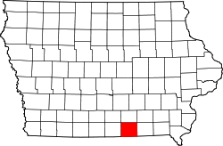
Centerville, IA 52544-0000Gründung: 17. Februar 1843 Gebildet aus: Original-County Vorwahl: 001 641 Demographie Einwohner: 12.887 (2010) Bevölkerungsdichte: 10 Einwohner/km² Geographie Fläche gesamt: 1.337 km² Wasserfläche: 54 km² Karte Website: www.appanoosecounty.net Das Appanoose County[1] ist ein County im Bundesstaat Iowa der Vereinigten Staaten von Amerika. Im Jahr 2010 hatte das County 12.887 Einwohner und eine Bevölkerungsdichte von 10 Einwohnern pro Quadratkilometer. Der Verwaltungssitz (County Seat) ist Centerville.
Inhaltsverzeichnis
Geografie
Das County liegt im Süden von Iowa, grenzt im Süden an Missouri und hat eine Fläche von 1.337 Quadratkilometern, wovon 54 Quadratkilometer Wasserfläche sind. Es grenzt an folgende Countys:
Lucas County Monroe County Wapello County Wayne County 
Davis County Putnam County
(Missouri)Schuyler County
(Missouri)Geschichte
Das Appanoose County wurde am 17. Februar 1843 aus als frei bezeichneten - in Wirklichkeit aber von Indianern besiedelten - Territorium gebildet. Benannt wurde es nach Appanoose, einem Häuptling der Fox-Indianer, der nicht am Black-Hawk-Krieg teilnahm.
Die heutige Bezirkshauptstadt hieß ehemals Chaldea. Später wurde sie zu Ehren des früheren Gouverneurs Senter von Tennessee in Senterville umbenannt. Allmählich wurde aus Senterville dann Centerville.
Im April 1848 wurde das für 160 Dollar erbaute Gerichtsgebäude in Betrieb genommen und diente als solches bis 1857. Das zweite Gerichtsgebäude wurde 1864 eröffnet und brannte bei den Feierlichkeiten zum 4. Juli durch explodierende Feuerwerkskörper bis auf die untere Etage ab. Das dritte Gerichtsgebäude wurde am 21. Mai 1903 in Betrieb genommen und wird heute noch genutzt.
Demografische Daten
Historische Einwohnerzahlen Census Einwohner ± in % 1850 3131 — 1860 11.931 300 % 1870 16.456 40 % 1880 16.636 1 % 1890 18.961 10 % 1900 25.927 40 % 1910 28.701 10 % 1920 30.535 6 % 1930 24.835 -20 % 1940 24.245 -2 % 1950 19.683 -20 % 1960 16.015 -20 % 1970 15.007 -6 % 1980 15.511 3 % 1990 13.743 -10 % 2000 13.721 -0,2 % 2010 12.887 -6 % Vor 1900[2] 1900–1990[3] 2010[4] Nach der Volkszählung im Jahr 2010 lebten im Appanoose County 12.887 Menschen in 5.766 Haushalten. Die Bevölkerungsdichte betrug 10 Einwohner pro Quadratkilometer.
Ethnisch betrachtet setzte sich die Bevölkerung zusammen aus 97,7 Prozent Weißen, 0,5 Prozent Afroamerikanern, 0,2 Prozent amerikanischen Ureinwohnern, 0,3 Prozent Asiaten sowie aus anderen ethnischen Gruppen; 1,0 Prozent stammten von zwei oder mehr Ethnien ab. Unabhängig von der ethnischen Zugehörigkeit waren 1,4 Prozent der Bevölkerung spanischer oder lateinamerikanischer Abstammung.
In den 5.766 Haushalten lebten statistisch je 2,23 Personen.
22,2 Prozent der Bevölkerung waren unter 18 Jahre alt, 57,9 Prozent waren zwischen 18 und 64 und 19,9 Prozent waren 65 Jahre oder älter. 51,9 Prozent der Bevölkerung war weiblich.
Das jährliche Durchschnittseinkommen eines Haushalts lag bei 33.663 USD. Das Pro - Kopf - Einkommen betrug 20.721 USD. 19,3 Prozent der Einwohner lebten unterhalb der Armutsgrenze.[5]
Städte und Gemeinden
- Brazil
- Centerville
- Cincinnati
- Dean
- Exline
- Garfield
- Iconium
- Livingston
- Moravia
- Moulton
- Mystic
- Numa
- Plano
- Rathbun
- Udell
- Unionville
- Walnut City
Einzelnachweise
- ↑ GNIS-ID: 465193. Abgerufen am 23. Februar 2011 (englisch).
- ↑ U.S. Census Bureau - Census of Population and Housing Abgerufen am 15. März 2011
- ↑ Auszug aus Census.gov Abgerufen am 16. Februar 2011
- ↑ United States Census 2010 Abgerufen am 20. Februar 2011
- ↑ U.S. Census Buero, State & County QuickFacts - Appanoose County Abgerufen am 10. Oktober 2011
Weblinks
- Offizielle Webseite
- Appanoose County Development Corporation
- U.S. Census Buero, State & County QuickFacts - Appanoose County
- Yahoo Bildersuche - Appanoose County
- www.city-data.com - Appanoose County
Liste der Countys in Iowa
Adair | Adams | Allamakee | Appanoose | Audubon | Benton | Black Hawk | Boone | Bremer | Buchanan | Buena Vista | Butler | Calhoun | Carroll | Cass | Cedar | Cerro Gordo | Cherokee | Chickasaw | Clarke | Clay | Clayton | Clinton | Crawford | Dallas | Davis | Decatur | Delaware | Des Moines | Dickinson | Dubuque | Emmet | Fayette | Floyd | Franklin | Fremont | Greene | Grundy | Guthrie | Hamilton | Hancock | Hardin | Harrison | Henry | Howard | Humboldt | Ida | Iowa | Jackson | Jasper | Jefferson | Johnson | Jones | Keokuk | Kossuth | Lee | Linn | Louisa | Lucas | Lyon | Madison | Mahaska | Marion | Marshall | Mills | Mitchell | Monona | Monroe | Montgomery | Muscatine | O'Brien | Osceola | Page | Palo Alto | Plymouth | Pocahontas | Polk | Pottawattamie | Poweshiek | Ringgold | Sac | Scott | Shelby | Sioux | Story | Tama | Taylor | Union | Van Buren | Wapello | Warren | Washington | Wayne | Webster | Winnebago | Winneshiek | Woodbury | Worth | Wright
Wikimedia Foundation.


