- Allamakee County
-
Verwaltung US-Bundesstaat: Iowa Verwaltungssitz: Waukon Adresse des
Verwaltungssitzes:County Courthouse
110 Allamakee Street
Waukon, IA 52172-1744Gründung: 20. Februar 1847 Gebildet aus: Original-County Vorwahl: 001 563 Demographie Einwohner: 14.330 (2010) Bevölkerungsdichte: 8,7 Einwohner/km² Geographie Fläche gesamt: 1.706 km² Wasserfläche: 50 km² Karte 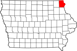
Website: www.co.allamakee.ia.us
Das Allamakee County[1] ist ein County im US-amerikanischen Bundesstaat Iowa. Bei der Volkszählung im Jahr 2010 hatte das County 14.330 Einwohner und eine Bevölkerungsdichte von 8,7 Einwohnern pro Quadratkilometer. Der Verwaltungssitz (County Seat) ist Waukon.[2]Inhaltsverzeichnis
Geografie
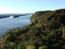
 Effigy Mounds am Mississippi
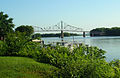 Black Hawk Bridge über den Mississippi
Das County liegt im äußersten Nordosten von Iowa und grenzt im Norden an Minnesota. Im Osten bildet der Mississippi die Grenze zu Wisconsin. Das Allamakee County hat eine Fläche von 1.706 Quadratkilometern, wovon 50 Quadratkilometer Wasserfläche sind.
Im Allamakee County liegt am Westufer des Mississippi ein Teil des einzigen National Monuments in Iowa: Effigy Mounds National Monument, ein archäologische Schutzgebiet für künstliche Hügelstrukturen früher Indianer-Kulturen.
An das Allamakee County grenzen folgende Countys:
Houston County
(Minnesota)Vernon County
(Wisconsin)Winneshiek County 
Crawford County
(Wisconsin)Fayette County Clayton County Geschichte
Das Allamakee County wurde am 20. Februar 1847 aus als frei bezeichneten - in Wirklichkeit aber von Indianern besiedelten - Territorium gebildet. Benannt wurde es entweder nach dem Händler Allan Mackee oder nach der indianischen Bezeichnung für Blitz. Beide Aussagen trifft man in der Literatur.
Demografische Daten
Historische Einwohnerzahlen Census Einwohner ± in % 1850 777 — 1860 12.237 1.000 % 1870 17.868 50 % 1880 19.791 10 % 1890 17.907 -10 % 1900 18.711 4 % 1910 17.328 -7 % 1920 17.285 -0,2 % 1930 16.328 -6 % 1940 17.184 5 % 1950 16.351 -5 % 1960 15.982 -2 % 1970 14.968 -6 % 1980 15.108 0,9 % 1990 13.855 -8 % 2000 14.675 6 % 2010 14.330 -2 % Vor 1900[3] 1900–1990[4] 2010[5] Nach der Volkszählung im Jahr 2010 lebten im Allamakee County 14.330 Menschen in 6.007 Haushalten. Die Bevölkerungsdichte betrug 8,7 Einwohner pro Quadratkilometer.
Ethnisch betrachtet setzte sich die Bevölkerung zusammen aus 96,0 Prozent Weißen, 0,8 Prozent Afroamerikanern, 0,3 Prozent amerikanischen Ureinwohnern, 0,2 Prozent Asiaten sowie aus anderen ethnischen Gruppen; 0,6 Prozent stammten von zwei oder mehr Ethnien ab. Unabhängig von der ethnischen Zugehörigkeit waren 5,3 Prozent der Bevölkerung spanischer oder lateinamerikanischer Abstammung.
In den 6.007 Haushalten lebten statistisch je 2,28 Personen.
23,8 Prozent der Bevölkerung waren unter 18 Jahre alt, 57,7 Prozent waren zwischen 18 und 64 und 18,5 Prozent waren 65 Jahre oder älter. 48,6 Prozent der Bevölkerung war weiblich.
Das jährliche Durchschnittseinkommen eines Haushalts lag bei 44.119 USD. Das Pro - Kopf - Einkommen betrug 20.604 USD. 14,1 Prozent der Einwohner lebten unterhalb der Armutsgrenze.[6]
Städte und Gemeinden
- Harpers Ferry
- Lansing
- New Albin
- Postville1
- Waterville
- Waukon (County-Seat)
- Gemeindefreie Siedlung
- Dorchester
1 - teilweise im Clayton County
Townships
Das Allamakee County ist in folgende Townships unterteilt:
- Center Township
- Fairview Township
- Franklin Township
- French Creek Township
- Hanover Township
- Iowa Township
- Jefferson Township
- Lafayette Township
- Lansing Township
- Linton Township
- Ludlow Township
- Makee Township
- Paint Creek Township
- Post Township
- Taylor Township
- Union City Township
- Union Prairie Township
- Waterloo Township
Einzelnachweise
- ↑ GNIS-ID: 465192. Abgerufen am 23. Februar 2011 (englisch).
- ↑ National Association of Counties Abgerufen am 10. Oktober 2011
- ↑ U.S. Census Bureau - Census of Population and Housing Abgerufen am 15. März 2011
- ↑ Auszug aus Census.gov Abgerufen am 16. Februar 2011
- ↑ United States Census 2010 Abgerufen am 20. Februar 2011
- ↑ U.S. Census Buero, State & County QuickFacts - Allamakee County Abgerufen am 10. Oktober 2011
Weblinks
-
 Commons: Allamakee County, Iowa – Sammlung von Bildern, Videos und Audiodateien
 - Offizielle Webseite
- Allamakee County Economic Development
- U.S. Census Buero, State & County QuickFacts - Allamakee County
- Yahoo Bildersuche - Allamakee County
- www.city-data.com

Liste der Countys in Iowa
Adair | Adams | Allamakee | Appanoose | Audubon | Benton | Black Hawk | Boone | Bremer | Buchanan | Buena Vista | Butler | Calhoun | Carroll | Cass | Cedar | Cerro Gordo | Cherokee | Chickasaw | Clarke | Clay | Clayton | Clinton | Crawford | Dallas | Davis | Decatur | Delaware | Des Moines | Dickinson | Dubuque | Emmet | Fayette | Floyd | Franklin | Fremont | Greene | Grundy | Guthrie | Hamilton | Hancock | Hardin | Harrison | Henry | Howard | Humboldt | Ida | Iowa | Jackson | Jasper | Jefferson | Johnson | Jones | Keokuk | Kossuth | Lee | Linn | Louisa | Lucas | Lyon | Madison | Mahaska | Marion | Marshall | Mills | Mitchell | Monona | Monroe | Montgomery | Muscatine | O'Brien | Osceola | Page | Palo Alto | Plymouth | Pocahontas | Polk | Pottawattamie | Poweshiek | Ringgold | Sac | Scott | Shelby | Sioux | Story | Tama | Taylor | Union | Van Buren | Wapello | Warren | Washington | Wayne | Webster | Winnebago | Winneshiek | Woodbury | Worth | Wright
Wikimedia Foundation.
Schlagen Sie auch in anderen Wörterbüchern nach:
Allamakee County — Admin ASC 2 Code Orig. name Allamakee County Country and Admin Code US.IA.005 US … World countries Adminstrative division ASC I-II
Allamakee County, Iowa — Infobox U.S. County county = Allamakee County state = Iowa seallink = map size = 250 founded = 1847 seat = Waukon largest city = area total sq mi = 659 area total km2 = 1706 area land sq mi = 640 area land km2 = 1656 area water sq mi = 19 area… … Wikipedia
National Register of Historic Places listings in Allamakee County, Iowa — Location of Allamakee County in Iowa This is a list of the National Register of Historic Places listings in Allamakee County, Iowa. This is intended to be a complete list of the properties and districts on the National Register of Historic Places … Wikipedia
Makee Township, Allamakee County, Iowa — Makee Township, Allamakee County Township … Wikipedia
Center Township, Allamakee County, Iowa — Infobox Settlement official name = Center Township, Allamakee County settlement type = Township nickname = motto = imagesize = image caption = image imagesize = image caption = image mapsize = map caption = mapsize1 = map caption1 = subdivision… … Wikipedia
Fairview Township, Allamakee County, Iowa — Infobox Settlement official name = Fairview Township, Allamakee County settlement type = Township nickname = motto = imagesize = image caption = image imagesize = image caption = image mapsize = map caption = mapsize1 = map caption1 = subdivision … Wikipedia
Franklin Township, Allamakee County, Iowa — Infobox Settlement official name = Franklin Township, Allamakee County settlement type = Township nickname = motto = imagesize = image caption = image imagesize = image caption = image mapsize = map caption = mapsize1 = map caption1 = subdivision … Wikipedia
French Creek Township, Allamakee County, Iowa — Infobox Settlement official name = French Creek Township, Allamakee County settlement type = Township nickname = motto = imagesize = image caption = image imagesize = image caption = image mapsize = map caption = mapsize1 = map caption1 =… … Wikipedia
Hanover Township, Allamakee County, Iowa — Infobox Settlement official name = Hanover Township, Allamakee County settlement type = Township nickname = motto = imagesize = image caption = image imagesize = image caption = image mapsize = map caption = mapsize1 = map caption1 = subdivision… … Wikipedia
Iowa Township, Allamakee County, Iowa — Infobox Settlement official name = Iowa Township, Allamakee County settlement type = Township nickname = motto = imagesize = image caption = image imagesize = image caption = image mapsize = map caption = mapsize1 = map caption1 = subdivision… … Wikipedia
Allamakee County


18+
© Academic, 2000-2026
- Kontaktieren Sie uns: Unterstützung, Werbung
Wörterbücher Export, schritte mit PHP, Joomla, Drupal, WordPress, MODx.