- Jefferson County (New York)
-
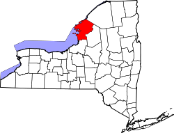
Verwaltung US-Bundesstaat: New York Verwaltungssitz: Watertown Gründung: 28. März 1805 Gebildet aus: Oneida County Vorwahl: 001 315 Demographie Einwohner: 111.738 (2000) Bevölkerungsdichte: 33,9 Einwohner/km² Geographie Fläche gesamt: 4.810 km² Wasserfläche: 1.515 km² Karte Website: www.co.jefferson.ny.us Jefferson County[1] ist ein County im Bundesstaat New York der Vereinigten Staaten von Amerika. Bei der Volkszählung im Jahr 2000 hatte das County 111.738 Einwohner und eine Bevölkerungsdichte von 34 Einwohnern pro Quadratkilometer. Der Verwaltungssitz (County Seat) ist Watertown.
Inhaltsverzeichnis
Geschichte
Das County wurde am 28. März 1805 aus Oneida County gebildet und nach US-Präsident Thomas Jefferson benannt.
Geografie
Das County hat eine Fläche von 4.810 Quadratkilometern, wovon 1.515 Quadratkilometer Wasserfläche sind. Jefferson County grenzt im Westen an den Ontariosee, im Norden an den Sankt-Lorenz-Strom, im Nordosten an St. Lawrence County, im Osten an Lewis County und im Süden an Oswego County.
Städte und Ortschaften
- Adams
- Adams Center
- Alexandria
- Alexandria Bay
- Antwerp
- Black River
- Brownville
- Calcium
- Cape Vincent
- Carthage
- Champion
- Chaumont
- Clayton
- Deferiet
- Depauville
- Dexter
- Ellisburg
- Evans Mills
- Fort Drum
- Glen Park
- Great Bend
- Henderson
- Herrings
- Hounsfield
- La Fargeville
- Le Ray
- Lorraine
- Lyme
- Mannsville
- Natural Bridge
- Orleans
- Pamelia
- Philadelphia
- Redwood
- Rodman
- Rutland
- Sackets Harbor
- Theresa
- Watertown
- West Carthage
- Wilna
- Worth
Einzelnachweise
- ↑ GNIS-ID: 974121. Abgerufen am 22. Februar 2011 (englisch).
Liste der Countys in New York
Albany | Allegany | Bronx | Broome | Cattaraugus | Cayuga | Chautauqua | Chemung | Chenango | Clinton | Columbia | Cortland | Delaware | Dutchess | Erie | Essex | Franklin | Fulton | Genesee | Greene | Hamilton | Herkimer | Jefferson | Kings (Brooklyn) | Lewis | Livingston | Madison | Monroe | Montgomery | Nassau | New York (Manhattan) | Niagara | Oneida | Onondaga | Ontario | Orange | Orleans | Oswego | Otsego | Putnam | Queens | Rensselaer | Richmond (Staten Island) | Rockland | Saratoga | Schenectady | Schoharie | Schuyler | Seneca | St. Lawrence | Steuben | Suffolk | Sullivan | Tioga | Tompkins | Ulster | Warren | Washington | Wayne | Westchester | Wyoming | Yates
Wikimedia Foundation.
Schlagen Sie auch in anderen Wörterbüchern nach:
Jefferson County, New York — Location in the state of New York … Wikipedia
National Register of Historic Places listings in Jefferson County, New York — Location of Jefferson County in New York … Wikipedia
Jefferson Heights, New York — Infobox Settlement official name = Jefferson Heights, New York settlement type = CDP nickname = motto = imagesize = image caption = image |pushpin pushpin label position = pushpin map caption =Location within the state of New York pushpin mapsize … Wikipedia
Jefferson Valley, New York — Infobox Settlement official name = Jefferson Valley, New York settlement type = CDP nickname = motto = imagesize = image caption = image |pushpin pushpin label position = pushpin map caption =Location within the state of New York pushpin mapsize … Wikipedia
County Route 97 (Suffolk County, New York) — County Route 97 Nicolls Road Route information Maintained by SCDPW Length … Wikipedia
County Route 11 (Suffolk County, New York) — County Route 11 Route information Maintained by SCDPW Length: 11.16 mi … Wikipedia
County Route 83 (Suffolk County, New York) — County Route 83 Route information Maintained by SCDPW Length: 11.55 mi … Wikipedia
County Route 111 (Suffolk County, New York) — County Route 111 Port Jefferson Westhampton Beach Highway Captain Daniel Roe Highway Route information Maintained by SCDPW … Wikipedia
County Route 46 (Suffolk County, New York) — County Route 46 William Floyd Parkway Route information Maintained by SCDPW Length … Wikipedia
County Route 105 (Suffolk County, New York) — County Route 105 Cross River Drive Route information Maintained by SCDPW Length … Wikipedia


