- King George Island
-
King George Island Admiralty Bay, King George Island
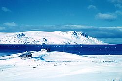
Foto von 1962Gewässer Südlicher Ozean Inselgruppe Südliche Shetlandinseln Geographische Lage 62° 2′ S, 58° 21′ W-62.033333333333-58.35655Koordinaten: 62° 2′ S, 58° 21′ W Länge 95 km Breite 25 km Fläche 1.150 km² Höchste Erhebung Rose Peak
655 mEinwohner 300 Stationspersonal (Winter)
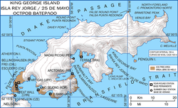
<1 Einw./km²Hauptort Villa las Estrellas Topographische Karte der Insel King George Island (deutsch „König-Georg-Insel“) ist mit 1.150 km² Fläche die größte Insel im Archipel der Südlichen Shetlandinseln in der Antarktis. Das Archipel liegt zwischen dem Südlichen Ozean und der Bransfield-Straße , (argentinisch) Mar de la Flota.
William Smith entdeckte die Insel 1819. Eine britische Expedition unter Edward Bransfield und mit Smith an Bord nahm die Insel am 30. Januar 1820 offiziell für Großbritannien in Besitz. Die Insel war 1821 erstmals bewohnt, als elf Walfänger vom Schiff Lord Melville hier zum Überwintern gezwungen waren. Benannt wurde die Insel nach König Georg III von Großbritannien und Irland. Argentinien nennt die Insel nach seinem Nationalfeiertag Isla 25 de Mayo.
Inhaltsverzeichnis
Geographie
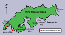
King George Island liegt rund 120 Kilometer vor der Küste des antarktischen Festlands. Die Insel ist 95 km lang, bis zu 25 km breit und erreicht im Rose Peak eine Höhe von 655 m[1] über dem Meer. Drei große Buchten im Süden der Insel prägen das Erscheinungsbild, die King George Bay, die Admiralty Bay sowie die Maxwell Bay. Über 90 % der Inselfläche sind vergletschert.
Forschungsstationen
Auf den eisfreien Flächen von King George Island, hauptsächlich im Südwesten der Insel, befinden sich eine Reihe von Antarktis-Forschungsstationen.
An der Maxwell Bay befinden sich:
- die große Frei-Station (Base Presidente Eduardo Frei Montalva, ehemals Base Teniente Rodolfo Marsh) (Chile). Diese Station verfügt über Bank, Post, einen Souvenirladen, eine Schule sowie ein Krankenhaus. In der Nähe befinden sich ein chilenischer Luftwaffenstützpunkt und das Hotel Estrella Polar.
- die benachbarte Bellingshausen-Station (Russland).
- die argentinische Jubany-Station.
Ferner befinden sich dort weitere Stationen von China, Südkorea und Uruguay. Deutschland betreibt das der argentinischen Station angegliederte Dallmann-Labor.
An der Admiralty Bay befinden sich
- die Station Comandante Ferraz (Brasilien),
- die Arctowski-Station (Polen), die auch von Touristen besucht werden kann.
- Die USA betreiben die Pieter J. Lenie Station in der Nähe der polnischen Station.
Die neun permant besetzten Stationen haben zusammengenommen eine Winterbesatzung von rund 300.
Flora und Fauna
Auf King George Island kommen die beiden Arten[2] an Blütenpflanzen in der Antarktis vor: Die Antarktische Perlwurz (Colobanthus quitensis) und die Antarktische Schmiele (Deschampsia antarctica). Auf der der Insel leben zudem verschiedene Pinguin- und Robbenarten wie der Zügelpinguin, der Südliche See-Elefant (Mirounga leonina) und der Antarktische Seebär (Arctocephalus gazella).
Weblinks
Einzelnachweise
- ↑ Rose Peak bei Peakbagger.com (englisch)
- ↑ UNEP Islands (englisch)
Wikimedia Foundation.


