- Nipissing District
-
Nipissing District 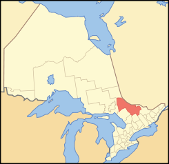
Lage des Nipissing District in OntarioProvinz Ontario Verwaltungssitz North Bay Fläche 17.065,07 km² Einwohner (2006) 84.668 Bevölkerungsdichte 5,0 Ew./km² Der Nipissing District ist ein Verwaltungsbezirk im Osten der kanadischen Provinz Ontario. Hauptort ist North Bay. Die Einwohnerzahl beträgt 84.668 (2006), die Fläche 17.065,07 km², was einer Bevölkerungsdichte von 5,0 Einwohnern je km² entspricht. Der Bezirk wurde 1858 gegründet.
Gliederung
Gemeinden:
- Bonfield
- Calvin
- Chisholm
- East Ferris
- Mattawa
- Mattawan
- North Bay
- Papineau-Cameron
- South Algonquin
- Temagami
- West Nipissing
Reservate:
- Bear Island 1
- Nipissing 10
Gemeindefreie Gebiete:
- Nipissing, Unorganized, North Part
- Nipissing, Unorganized, South Part
Weblinks

Einstufige Gemeinden: Brant | Brantford | Chatham-Kent | Greater Sudbury | Haldimand | Hamilton | Kawartha Lakes | Norfolk | Ottawa | Prince Edward | Toronto
Regionalgemeinden: Durham | Halton | Muskoka | Niagara | Oxford | Peel | Waterloo | York
Countys: Bruce | Dufferin | Elgin | Essex | Frontenac | Grey | Haliburton | Hastings | Huron | Lambton | Lanark | Leeds and Grenville | Lennox and Addington | Middlesex | Northumberland | Perth | Peterborough | Prescott and Russell | Renfrew | Simcoe | Stormont, Dundas and Glengarry | Wellington
Distrikte: Algoma | Cochrane | Kenora | Manitoulin | Nipissing | Parry Sound | Rainy River | Sudbury | Thunder Bay | Timiskaming
Wikimedia Foundation.
Schlagen Sie auch in anderen Wörterbüchern nach:
Nipissing District — District Location of Nipissing District in Ontario … Wikipedia
Nipissing District, Ontario — Infobox Settlement official name = Nipissing District other name = native name = nickname = settlement type = District motto = imagesize = image caption = flag size = image seal size = image shield = shield size = city logo = citylogo size =… … Wikipedia
Nipissing District municipal elections, 2010 — Elections were held in the organized municipalities in the Nipissing District of Ontario on October 25, 2010 in conjunction with municipal elections across the province. Contents 1 Bonfield 2 Calvin 3 Chisholm 4 … Wikipedia
List of secondary highways in Nipissing District — This is a list of secondary highways in Nipissing District, many of which serve as logging roads or provide access to Algonquin Park and sparsely populated areas in the Nipissing District of northeastern Ontario. Contents 1 Highway 523 2 Highway… … Wikipedia
Unorganized North Nipissing District — Unorganized Nipissing North Part Unorganized territory … Wikipedia
Unorganized South Nipissing District — Unorganized Nipissing South Part Unorganized territory The Barron Canyon in Algonquin Park … Wikipedia
Moore Creek (Nipissing District, Ontario) — For other places with the same name, see Moore Creek (disambiguation). Coordinates: 45°29′18″N 77°58′26″W / 45.48833°N 77.97389°W … Wikipedia
Daisy Lake (Nipissing District, Ontario) — Coordinates: 45°39′37″N 78°56′38″W / 45.66028°N 78.94389°W / 45.66028; 78.94389 … Wikipedia
Mink Lake, Nipissing District — Coordinates: 46°03′24″N 78°45′52″W / 46.05667°N 78.76444°W / 46.05667; 78.76444 … Wikipedia
Sturgeon Lake (Nipissing District, Ontario) — Infobox lake lake name = Sturgeon Lake image lake = caption lake = image bathymetry = caption bathymetry= location = Nipissing District, Ontario coords = coord|46|32|41|N|79|25|05|W|region:CA ON type:waterbody|display=inline,title type = inflow … Wikipedia
Nipissing District

18+
© Academic, 2000-2026
- Kontaktieren Sie uns: Unterstützung, Werbung
Wörterbücher Export, schritte mit PHP, Joomla, Drupal, WordPress, MODx.