- Thunder Bay District
-
Thunder Bay District 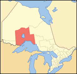
Lage des Thunder Bay District in OntarioProvinz Ontario Verwaltungssitz Thunder Bay Fläche 103.706,27 km² Einwohner (2006) 149.063 Bevölkerungsdichte 1,4 Ew./km² Der Thunder Bay District ist ein Verwaltungsbezirk im Zentrum der kanadischen Provinz Ontario. Hauptort ist Thunder Bay. Die Einwohnerzahl beträgt 149.063 (2006), die Fläche 103.706,27 km², was einer Bevölkerungsdichte von 1,4 Einwohnern je km² entspricht. Der Bezirk liegt am Nordufer des Lake Superior und entstand 1871 aus dem westlichen Teil des Algoma District. In der Folge wurden einzelne Gebiete abgetrennt und neu entstandenen Bezirken zugeteilt: Rainy River District 1885, Kenora District 1907 und Cochrane District 1921.
Gliederung
- Gemeinden
- Conmee
- Dorion
- Gillies
- Greenstone
- Manitouwadge
- Marathon
- Neebing
- Nipigon
- O'Connor
- Oliver Paipoonge
- Red Rock
- Schreiber
- Shuniah
- Terrace Bay
- Thunder Bay
- Reservate
- Aroland 83
- Fort William 52
- Ginoogaming First Nation
- Gull River 55
- Lac des Mille Lacs 22A1
- Lake Helen 53A
- Long Lake 58
- Ojibway Nation of Saugeen
- Pays Plat 51
- Pic Mobert North
- Pic Mobert South
- Pic River 50
- Rocky Bay 1
- Seine River 22A2
- Whitesand
- Gemeindefreie Gebiete
- Thunder Bay, Unorganized
Weblinks

Einstufige Gemeinden: Brant | Brantford | Chatham-Kent | Greater Sudbury | Haldimand | Hamilton | Kawartha Lakes | Norfolk | Ottawa | Prince Edward | Toronto
Regionalgemeinden: Durham | Halton | Muskoka | Niagara | Oxford | Peel | Waterloo | York
Countys: Bruce | Dufferin | Elgin | Essex | Frontenac | Grey | Haliburton | Hastings | Huron | Lambton | Lanark | Leeds and Grenville | Lennox and Addington | Middlesex | Northumberland | Perth | Peterborough | Prescott and Russell | Renfrew | Simcoe | Stormont, Dundas and Glengarry | Wellington
Distrikte: Algoma | Cochrane | Kenora | Manitoulin | Nipissing | Parry Sound | Rainy River | Sudbury | Thunder Bay | Timiskaming
Wikimedia Foundation.
Schlagen Sie auch in anderen Wörterbüchern nach:
Thunder Bay District, Ontario — Infobox Settlement official name = Thunder Bay District other name = native name = nickname = settlement type = District motto = imagesize = image caption = flag size = image seal size = image shield = shield size = city logo = citylogo size =… … Wikipedia
List of secondary highways in Thunder Bay District — This is a list of secondary highways in Thunder Bay District, most of which serve as logging roads or provide access to the isolated and sparsely populated areas in the Thunder Bay District of northern Ontario. Contents 1 Highway 527 2 Highway… … Wikipedia
Unorganized Thunder Bay District — Unorganized Thunder Bay Unorganized Sleeping Giant Provincial Park … Wikipedia
Cleaver Lake (Thunder Bay District) — For other lakes named Cleaver Lake, see Cleaver Lake. Cleaver Lake Location Thunder Bay District, Ontario Coordinates … Wikipedia
Daisy Lake (Thunder Bay District) — For other places with the same name, see Daisy Lake (disambiguation). Coordinates: 49°45′15″N 87°29′09″W / 49.75417°N 87.48583°W / … Wikipedia
Armstrong, Thunder Bay District, Ontario — Armstrong is a community and divisional point on the Canadian National Railway in the unorganized portion of Thunder Bay District, Ontario. The Whitesand First Nation s Armstrong Settlement is coterminous to this community … Wikipedia
Thunder Bay, Unorganized, Ontario — Thunder Bay, Unorganized is an unorganized area in northwestern Ontario, Canada in Thunder Bay District. It comprises all parts of the district that are not part of an incorporated municipality or a First Nations reserve.Local Service… … Wikipedia
Thunder Bay Generating Station — is a coal fired station owned by Ontario Power Generation, located on Mission Island on the shore of Thunder Bay in Lake Superior. The plant provides energy to parts of Thunder Bay District in Northwestern Ontario.Thunder Bay Generating Station… … Wikipedia
Thunder Bay — hat folgende Bedeutungen: Thunder Bay (Ontario), eine Stadt in der kanadischen Provinz Ontario Thunder Bay District, ein Bezirk im Nordwesten von Ontario Thunder Bay (Michigan), eine Bucht am Huronsee im amerikanischen Bundesstaat Michigan, an… … Deutsch Wikipedia
Thunder Bay — For other uses, see Thunder Bay (disambiguation). Thunder Bay City Marina Park, and Downtown Thunder Bay North … Wikipedia
Thunder Bay District

18+
© Academic, 2000-2025
- Kontaktieren Sie uns: Unterstützung, Werbung
Wörterbücher Export, schritte mit PHP, Joomla, Drupal, WordPress, MODx.