- Lambton County
-
Lambton County 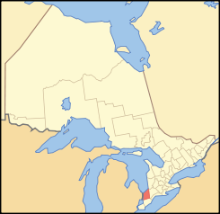
Lage des Lambton County in OntarioProvinz Ontario County Seat Wyoming Fläche 3001,70 km² Einwohner (2006) 128.204 Bevölkerungsdichte 42,7 Ew./km² Lambton County ist ein County im Südwesten der kanadischen Provinz Ontario. Der County Seat ist Wyoming in der Gemeinde Plympton-Wyoming. Die Einwohnerzahl beträgt 128.204 (2006), die Fläche 3001,70 km², was einer Bevölkerungsdichte von 42,7 Einwohnern je km² entspricht. Das County wird begrenzt durch den Huronsee im Norden, den St. Clair River im Westen und den Lake St. Clair im Südwesten.
Gemeinden
Im Lambton County liegen folgende Gemeinden:
- Brooke-Alvinston
- Dawn-Euphemia
- Enniskillen
- Lambton Shores
- Oil Springs
- Petrolia
- Plympton-Wyoming
- Point Edward
- Sarnia
- St. Clair
- Warwick
Administrativ eigenständig ist das Reservat Kettle Point 44 der Chippewa.
Weblinks

Einstufige Gemeinden: Brant | Brantford | Chatham-Kent | Greater Sudbury | Haldimand | Hamilton | Kawartha Lakes | Norfolk | Ottawa | Prince Edward | Toronto
Regionalgemeinden: Durham | Halton | Muskoka | Niagara | Oxford | Peel | Waterloo | York
Countys: Bruce | Dufferin | Elgin | Essex | Frontenac | Grey | Haliburton | Hastings | Huron | Lambton | Lanark | Leeds and Grenville | Lennox and Addington | Middlesex | Northumberland | Perth | Peterborough | Prescott and Russell | Renfrew | Simcoe | Stormont, Dundas and Glengarry | Wellington
Distrikte: Algoma | Cochrane | Kenora | Manitoulin | Nipissing | Parry Sound | Rainy River | Sudbury | Thunder Bay | Timiskaming
Wikimedia Foundation.
Schlagen Sie auch in anderen Wörterbüchern nach:
Lambton County, Ontario — Infobox Settlement name = official name =Lambton other name = native name = nickname = settlement type =County total type = motto = imagesize = image caption = flag size = image seal size = image shield = shield size = image blank emblem = blank… … Wikipedia
List of county roads in Lambton County, Ontario — This page lists all of the numbered county roads in Lambton County, Ontario … Wikipedia
Lambton—Kent—Middlesex — Ontario electoral district Lambton Kent Middlesex in relation to other southern Ontario electoral districts … Wikipedia
Lambton Shores — City Grand Bend … Wikipedia
Lambton—Kent — was a federal electoral district in Ontario, Canada, that was represented in the Canadian House of Commons from 1935 to 1979. This riding was created in 1933 from parts of Kent, Lambton East and Lambton West ridings. It was initially defined as… … Wikipedia
Lambton — ist der Familienname folgender Personen: Antony Lambton (1922–2006), britischer Politiker John George Lambton, 1. Earl of Durham, gen. „Radical Jack“ (1792–1840), britischer Staatsmann der Whig Partei, der das Vereinigte Königreich auf dem Wiener … Deutsch Wikipedia
New Lambton, County Durham — Coordinates: 54°51′29″N 1°30′40″W / 54.858°N 1.511°W / 54.858; 1.511 … Wikipedia
Lambton — is the name of several places and people:People*Edward Lambton, 7th Earl of Durham (born 1961), or Ned Lambton, is the current Earl of Durham *Antony Lambton (1922 2006), formerly 6th Earl of Durham and later claimed Viscount Lambton, disclaimed… … Wikipedia
Forest, Lambton County, Ontario — Forest is a small town located near Sarnia, Ontario in Canada. It is very close to the shore of Lake Huron and is part of the municipality of Lambton Shores and the county of Lambton. Population In 2001, the last year where Forest was a… … Wikipedia
Lambton—Kent—Middlesex (provincial electoral district) — Infobox Canada electoral district name = Lambton Kent Middlesex province = Ontario caption = prov status = active prov created = 1999 prov abolished = prov election first = 1999 prov election last = 2007 prov rep = Maria Van Bommel prov rep link … Wikipedia
Lambton County

18+
© Academic, 2000-2026
- Kontaktieren Sie uns: Unterstützung, Werbung
Wörterbücher Export, schritte mit PHP, Joomla, Drupal, WordPress, MODx.