- Kenora District
-
Kenora District 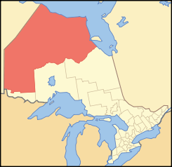
Lage des Kenora District in OntarioProvinz Ontario Verwaltungssitz Kenora Fläche 407.192,97 km² Einwohner (2006) 64.419 Bevölkerungsdichte 0,2 Ew./km² Der Kenora District ist ein Verwaltungsbezirk im Nordwesten der kanadischen Provinz Ontario. Hauptort ist Kenora. Die Einwohnerzahl beträgt 64.419 (2006), die Fläche 407.192,97 km², was einer Bevölkerungsdichte von 0,2 Einwohnern je km² entspricht. Der Bezirk wurde 1907 aus Teilen des Rainy River District gebildet. Er bedeckt 38 % der Fläche der Provinz, ist größer als Deutschland und fast so groß wie Kalifornien. Das Gebiet nördlich des Albany River, das manchmal auch als Patricia Portion bezeichnet wird, kam 1912 zu Ontario.
Gliederung
Gemeinden:
- Dryden
- Ear Falls
- Ignace
- Kenora
- Machin
- Pickle Lake
- Red Lake
- Sioux Lookout
- Sioux Narrows-Nestor Falls
Reservate:
- Attawapiskat 91A
- Bearskin Lake
- Cat Lake 63C
- Deer Lake
- Eagle Lake 27
- English River 21
- Fort Albany 67
- Fort Hope 64
- Fort Severn 89
- Islington 29
- Kasabonika Lake
- Kee-Way-Win
- Kenora 38B
- Kingfisher Lake 1
- Kitchenuhmaykoosib Aaki 84
- Lac Seul 28
- Lake of the Woods 31G
- Lake of the Woods 37
- Marten Falls 65
- Muskrat Dam Lake
- Neskantaga
- North Spirit Lake
- Northwest Angle 33B
- Osnaburgh 63B
- Pikangikum 14
- Poplar Hill
- Rat Portage 38A
- Sabaskong Bay 35D
- Sachigo Lake 1
- Sachigo Lake 2
- Sandy Lake 88
- Shoal Lake 39A
- Shoal Lake 40
- Shoal Lake 34B2
- The Dalles 38C
- Wabauskang 21
- Wabigoon Lake 27
- Wapakeka 1
- Wapakeka 2
- Wawakapewin
- Weagamow Lake 87
- Whitefish Bay 32A
- Whitefish Bay 33A
- Whitefish Bay 34A
- Wunnumin 1
- Wunnumin 2
Gemeindefreie Gebiete:
- Kenora, Unorganized
Weblinks

Einstufige Gemeinden: Brant | Brantford | Chatham-Kent | Greater Sudbury | Haldimand | Hamilton | Kawartha Lakes | Norfolk | Ottawa | Prince Edward | Toronto
Regionalgemeinden: Durham | Halton | Muskoka | Niagara | Oxford | Peel | Waterloo | York
Countys: Bruce | Dufferin | Elgin | Essex | Frontenac | Grey | Haliburton | Hastings | Huron | Lambton | Lanark | Leeds and Grenville | Lennox and Addington | Middlesex | Northumberland | Perth | Peterborough | Prescott and Russell | Renfrew | Simcoe | Stormont, Dundas and Glengarry | Wellington
Distrikte: Algoma | Cochrane | Kenora | Manitoulin | Nipissing | Parry Sound | Rainy River | Sudbury | Thunder Bay | Timiskaming
Wikimedia Foundation.
Schlagen Sie auch in anderen Wörterbüchern nach:
Kenora District, Ontario — Infobox Settlement official name = Kenora District other name = native name = nickname = settlement type = District motto = imagesize = image caption = flag size = image seal size = image shield = shield size = city logo = citylogo size =… … Wikipedia
List of secondary highways in Kenora District — This is a list of secondary highways in Kenora District, most of which serve as logging roads or provide access to isolated and sparsely populated areas in the Kenora District of northwestern Ontario. Contents 1 Highway 525 2 Highway 594 3… … Wikipedia
Unorganized Kenora District — Unorganized Kenora Unorganized Scenery near Minaki … Wikipedia
McIntosh, Kenora District, Ontario — Coordinates: 49°58′46″N 93°36′39″W / 49.97944°N 93.61083°W / 49.97944; 93.61083 … Wikipedia
Abram Lake (Kenora District, Ontario) — Infobox lake lake name = Abram Lake image lake = caption lake = image bathymetry = caption bathymetry= location = Kenora District, Ontario coords = coord|50|03|26|N|91|55|55|W|region:CA ON type:waterbody|display=inline,title type = inflow =… … Wikipedia
Sturgeon Lake (Hayes Watershed - Kenora District, Ontario) — Infobox lake lake name = Sturgeon Lake image lake = caption lake = image bathymetry = caption bathymetry= location = Kenora District, Ontario coords = coord|55|23|48|N|90|54|19|W|region:CA ON type:waterbody|display=inline,title type = inflow =… … Wikipedia
Sturgeon River (Kenora District, Ontario) — Infobox River river name = Sturgeon River image size = caption = origin = mouth = English River basin countries = length = convert|81|km|mi|0|abbr=on elevation = mouth elevation = convert|313|m|ft|0|abbr=on discharge = watershed = The Sturgeon… … Wikipedia
Kenora, Unorganized, Ontario — Kenora, Unorganized is an unorganized area in northwestern Ontario, Canada in Kenora District. Comprising 98.39 percent of the Kenora District s land area, yet only 10.93 percent of its population, it is essentially the remainder of the district… … Wikipedia
Kenora (disambiguation) — Kenora may refer to:* City of Kenora, Ontario, Canada * Kenora (electoral district), federal and provincial electoral districts in Ontario * Kenora District, Ontario, a territorial district in Ontarioee also* Canora disambiguation page … Wikipedia
Kenora — This article is about a city in Northwestern Ontario, Canada. For other uses, see Kenora (disambiguation). Kenora City … Wikipedia
Kenora District

18+
© Academic, 2000-2026
- Kontaktieren Sie uns: Unterstützung, Werbung
Wörterbücher Export, schritte mit PHP, Joomla, Drupal, WordPress, MODx.