- Parry Sound District
-
Parry Sound District
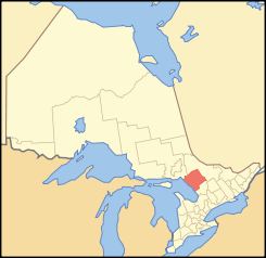
Lage des Parry Sound District in OntarioProvinz Ontario Verwaltungssitz Parry Sound Fläche 9222,04 km² Einwohner (2006) 40.918 Bevölkerungsdichte 4,4 Ew./km² Der Parry Sound District ist ein Verwaltungsbezirk im Zentrum der kanadischen Provinz Ontario. Hauptort ist Parry Sound. Die Einwohnerzahl beträgt 40.918 (2006), die Fläche 9222,04 km², was einer Bevölkerungsdichte von 4,4 Einwohnern je km² entspricht. Der Bezirk liegt am Ostufer der Georgsbucht des Huronsees und umfasst einen großen Teil des Algonquin Provincial Park.
Gliederung
Gemeinden:
- Armour
- Burk's Falls
- Callander
- Carling
- Joly
- Kearney
- Machar
- Magnetawan
- McDougall
- McKellar
- McMurrich/Monteith
- Nipissing
- Parry Sound
- Perry
- Powassan
- Ryerson
- Seguin
- South River
- Strong
- Sundridge
- The Archipelago
- Whitestone
Reservate:
- Dokis 9
- French River 13
- Henvey Inlet 2
- Magnetewan 1
- Naiscoutaing 17A
- Parry Island First Nation
- Shawanaga 17
Gemeindefreie Gebiete:
- Parry Sound, Unorganized, Centre Part
- Parry Sound, Unorganized, North East Part
Weblinks
Einstufige Gemeinden: Brant | Brantford | Chatham-Kent | Greater Sudbury | Haldimand | Hamilton | Kawartha Lakes | Norfolk | Ottawa | Prince Edward | Toronto
Regionalgemeinden: Durham | Halton | Muskoka | Niagara | Oxford | Peel | Waterloo | York
Countys: Bruce | Dufferin | Elgin | Essex | Frontenac | Grey | Haliburton | Hastings | Huron | Lambton | Lanark | Leeds and Grenville | Lennox and Addington | Middlesex | Northumberland | Perth | Peterborough | Prescott and Russell | Renfrew | Simcoe | Stormont, Dundas and Glengarry | Wellington
Distrikte: Algoma | Cochrane | Kenora | Manitoulin | Nipissing | Parry Sound | Rainy River | Sudbury | Thunder Bay | Timiskaming
Wikimedia Foundation.
Schlagen Sie auch in anderen Wörterbüchern nach:
Parry Sound District — District Location of Parry Sound District in Ontario … Wikipedia
Parry Sound District, Ontario — Infobox Settlement official name = Parry Sound District other name = native name = nickname = settlement type = District motto = imagesize = image caption = flag size = image seal size = image shield = shield size = city logo = citylogo size =… … Wikipedia
List of secondary highways in Parry Sound District — This is a list of secondary highways in Parry Sound District, many of which provide access to isolated settlements and recreational properties within the Parry Sound District of Ontario. Contents 1 Highway 510 2 Highway 518 3 Highway 520 … Wikipedia
Crawford Lake (Parry Sound District, Ontario) — Crawford Lake Location Magnetawan, Parry Sound District, Ontario Coordinates … Wikipedia
Doe Lake (Parry Sound District, Ontario) — Doe Lake Location Parry Sound District, Ontario Coordinates 45°32′35″N … Wikipedia
Sand Lake (Parry Sound District, Ontario) — Infobox lake lake name = Sand Lake image lake = caption lake = image bathymetry = caption bathymetry= location = Parry Sound District, Ontario, Canada flagicon|Canada coords = coord|46|6|8|N|79|39|39|W|region:CA ON… … Wikipedia
Otter Lake (Seguin, Parry Sound District, Ontario) — Otter Lake Sunset over Otter Lake Location Seguin, Ontario Coordinates … Wikipedia
Lost Channel, Parry Sound District, Ontario — Lost Channel is a ghost town in Parry Sound District, Ontario. It all started when Lauder, Spears and Howland of Toronto, began producing lumber under contract to the Schroeder Mills Timber Co., of Milwaukee, Wisconsin. In the spring of 1917,… … Wikipedia
Parry Sound, Ontario — Parry Sound Town Looking over the town and the sound … Wikipedia
Parry Sound — may refer to: * Parry Sound, Ontario * Parry Sound (a bay in Georgian Bay) * Parry Sound District, Ontario * Parry Sound (electoral district) … Wikipedia