- Cochrane District
-
Cochrane District 
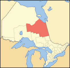
Lage des Cochrane District in OntarioProvinz Ontario Verwaltungssitz Cochrane Fläche 141.243,97 km² Einwohner (2006) 82.503 Bevölkerungsdichte 0,6 Ew./km² Der Cochrane District ist ein Verwaltungsbezirk im Nordosten der kanadischen Provinz Ontario. Hauptort ist Cochrane. Die Einwohnerzahl beträgt 82.503 (2006), die Fläche 141.243,97 km², was einer Bevölkerungsdichte von 0,6 Einwohnern je km² entspricht. Der Bezirk wurde 1921 aus Teilen des Timiskaming District und des Thunder Bay District gebildet.
Gliederung
Gemeinden:
- Black River-Matheson
- Cochrane
- Fauquier-Strickland
- Hearst
- Iroquois Falls
- Kapuskasing
- Mattice-Val Côté
- Moonbeam
- Moosonee
- Opasatika
- Smooth Rock Falls
- Timmins
- Val Rita-Harty
Reservate:
- Abitibi 70
- Constance Lake 92
- Factory Island 1
- Flying Post 73
- Fort Albany 67
- Moose Factory 68
- New Post 69
- New Post 69A
Gemeindefreie Gebiete:
- Cochrane, Unorganized, North Part
- Cochrane, Unorganized, South East Part
- Cochrane, Unorganized, South West Part
Weblinks
Einstufige Gemeinden: Brant | Brantford | Chatham-Kent | Greater Sudbury | Haldimand | Hamilton | Kawartha Lakes | Norfolk | Ottawa | Prince Edward | Toronto
Regionalgemeinden: Durham | Halton | Muskoka | Niagara | Oxford | Peel | Waterloo | York
Countys: Bruce | Dufferin | Elgin | Essex | Frontenac | Grey | Haliburton | Hastings | Huron | Lambton | Lanark | Leeds and Grenville | Lennox and Addington | Middlesex | Northumberland | Perth | Peterborough | Prescott and Russell | Renfrew | Simcoe | Stormont, Dundas and Glengarry | Wellington
Distrikte: Algoma | Cochrane | Kenora | Manitoulin | Nipissing | Parry Sound | Rainy River | Sudbury | Thunder Bay | Timiskaming
Wikimedia Foundation.
