- Algoma District
-
Algoma District 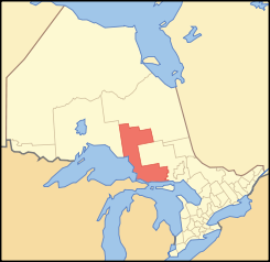
Lage des Algoma District in OntarioProvinz Ontario Verwaltungssitz Sault Ste. Marie Fläche 48.734,66 km² Einwohner (2006) 117.461 Bevölkerungsdichte 2,4 Ew./km² Der Algoma District ist ein Verwaltungsbezirk im Norden der kanadischen Provinz Ontario. Hauptort ist Sault Ste. Marie. Die Einwohnerzahl beträgt 117.461 (2006), die Fläche 48.734,66 km², was einer Bevölkerungsdichte von 2,4 Einwohnern je km² entspricht.
Der Algoma District bildet einen Teil der Küste des Lake Superior, des obersten der Großen Seen. Der Bezirk wurde 1858 gegründet und erstreckte sich nach Westen bis zur Grenze von Minnesota. Mit der Einrichtung weiterer Bezirke verkleinerte sich die Fläche des Bezirks: Thunder Bay District 1871, Manitoulin District 1888, Sudbury District 1894 und Timiskaming District 1912.
Gliederung
Gemeinden:
- Blind River
- Bruce Mines
- Dubreuilville
- Elliot Lake
- Hilton Beach
- Hilton
- Hornepayne
- Huron Shores
- Jocelyn
- Johnson
- Laird
- Michipicoten
- Plummer Additional
- Prince
- Sault Ste. Marie
- Spanish
- St. Joseph
- Tarbutt and Tarbutt Additional
- The North Shore
- Thessalon
- White River
Reservate:
- Garden River 14
- Goulais Bay 15A
- Gros Cap 49
- Missanabie 62
- Mississagi River 8
- Rankin Location 15D
- Sagamok
- Serpent River 7
- Thessalon 12
Gemeindefreie Gebiete:
- Algoma, Unorganized, North Part
- Algoma, Unorganized, South East Part
Weblinks

Einstufige Gemeinden: Brant | Brantford | Chatham-Kent | Greater Sudbury | Haldimand | Hamilton | Kawartha Lakes | Norfolk | Ottawa | Prince Edward | Toronto
Regionalgemeinden: Durham | Halton | Muskoka | Niagara | Oxford | Peel | Waterloo | York
Countys: Bruce | Dufferin | Elgin | Essex | Frontenac | Grey | Haliburton | Hastings | Huron | Lambton | Lanark | Leeds and Grenville | Lennox and Addington | Middlesex | Northumberland | Perth | Peterborough | Prescott and Russell | Renfrew | Simcoe | Stormont, Dundas and Glengarry | Wellington
Distrikte: Algoma | Cochrane | Kenora | Manitoulin | Nipissing | Parry Sound | Rainy River | Sudbury | Thunder Bay | Timiskaming
Wikimedia Foundation.
Schlagen Sie auch in anderen Wörterbüchern nach:
Algoma District — District Agawa Canyon … Wikipedia
Algoma District, Ontario — Algoma District is a district and census division in Northeastern Ontario in the Canadian province of Ontario. It was created in 1858 comprising territory as far west as Minnesota. Since then, it has shrunk, as other districts were created by the … Wikipedia
Algoma District School Board — is a public school board in the Canadian province of Ontario. The school board is the school district administrator for the Algoma District. Secondary Schools = Blind River = * W.C. Eaket Secondary School = Chapleau = * Chapleau High… … Wikipedia
Unorganized North Algoma District — Algoma, Unorganized, North Part Unorganized area An aerial view of Goulais River. Coord … Wikipedia
List of secondary highways in Algoma District — This is a list of secondary highways in Algoma District, most of which serve as logging roads or provide access to isolated and sparsely populated areas in the Algoma District of northeastern Ontario, or . Contents 1 Highway 519 2 Highway 532 3… … Wikipedia
Coldwater River (Algoma District) — Coordinates: 47°28′05″N 84°47′17″W / 47.46806°N 84.78806°W / 47.46806; 84.78806 … Wikipedia
Daisy Lake (Algoma District, Ontario) — Coordinates: 47°43′36″N 84°09′50″W / 47.72667°N 84.16389°W / 47.72667; 84.16389 … Wikipedia
Algoma (electoral district) — Algoma (also known as Algoma Manitoulin) was a federal electoral district in Ontario, Canada, represented in the Canadian House of Commons from 1867 to 1904 and from 1968 to 2004. HistoryThe district was created in the British North America Act… … Wikipedia
Algoma — may refer to: * Algoma (word) * Algoma (electoral district) * Algoma Central Railway * Algoma District, Ontario * Algoma, Mississippi * Algoma, Oregon * Algoma, West Virginia * Algoma, Wisconsin * Algoma, Winnebago County, Wisconsin * Algoma… … Wikipedia
Algoma (word) — Algoma is a placename given to many different places throughout the United States and Canada. Examples include Algoma District, Ontario, Algoma, Oregon, Algoma, Wisconsin, and Algoma Township, Michigan. Algoma also lends its name to companies… … Wikipedia
Algoma District

18+
© Academic, 2000-2026
- Kontaktieren Sie uns: Unterstützung, Werbung
Wörterbücher Export, schritte mit PHP, Joomla, Drupal, WordPress, MODx.