- Manitoulin District
-
Manitoulin District 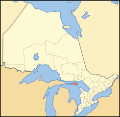
Lage des Manitoulin District in OntarioProvinz Ontario Verwaltungssitz Gore Bay Fläche 4796,0 km² Einwohner (2006) 13.090 Bevölkerungsdichte 2,7 Ew./km² Der Manitoulin District ist ein Verwaltungsbezirk im Zentrum der kanadischen Provinz Ontario. Hauptort ist Gore Bay. Die Einwohnerzahl beträgt 13.090 (2006), die Fläche 4796,0 km², was einer Bevölkerungsdichte von 2,7 Einwohnern je km² entspricht. Der Bezirk umfasst die Insel Manitoulin und weitere Inseln im Huronsee.
Gemeinden
- Assiginack
- Barrie Island
- Billings
- Burpee and Mills
- Central Manitoulin
- Cockburn Island
- Gordon
- Gore Bay
- Northeastern Manitoulin and The Islands
- Tehkummah
Weblinks

Einstufige Gemeinden: Brant | Brantford | Chatham-Kent | Greater Sudbury | Haldimand | Hamilton | Kawartha Lakes | Norfolk | Ottawa | Prince Edward | Toronto
Regionalgemeinden: Durham | Halton | Muskoka | Niagara | Oxford | Peel | Waterloo | York
Countys: Bruce | Dufferin | Elgin | Essex | Frontenac | Grey | Haliburton | Hastings | Huron | Lambton | Lanark | Leeds and Grenville | Lennox and Addington | Middlesex | Northumberland | Perth | Peterborough | Prescott and Russell | Renfrew | Simcoe | Stormont, Dundas and Glengarry | Wellington
Distrikte: Algoma | Cochrane | Kenora | Manitoulin | Nipissing | Parry Sound | Rainy River | Sudbury | Thunder Bay | Timiskaming

Wikimedia Foundation.