- Pragelato Plan
-
Pragelato 
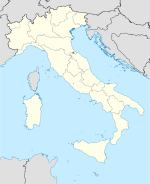

Staat: Italien Region: Piemont Provinz: Turin (TO) Koordinaten: 45° 1′ N, 6° 57′ O45.0166666666676.951518Koordinaten: 45° 1′ 0″ N, 6° 57′ 0″ O Höhe: 1.518 m s.l.m. Fläche: 88 km² Einwohner: 676 (2007) Bevölkerungsdichte: 5 Einw./km² Postleitzahl: 10060 Vorwahl: 0122 ISTAT-Nummer: 001201 Demonym: Pragelatesi Website: Pragelato Pragelato (okzitanisch Pratjalat) ist eine Gemeinde mit 676 Einwohnern[1] in der italienischen Provinz Turin (TO), Region Piemont.
Die Gemeinde besteht aus den Ortsteilen La Ruà, Allevè, Chezal, Duc, Grand Puy, Granges, Jousseaud, Laval, Pattemouche, Plan, Rif, Rivets, Seytes, Troncea, Souchéres Basses, Souchère Haute, Traverses, Villardamond, Val Tronche und Tronchée. Die Nachbargemeinden sind Exilles, Oulx, Salbertrand, Usseaux, Fenestrelle, Sauze d’Oulx, Massello, Sestriere, Sauze di Cesana, Salza di Pinerolo und Prali. Die Telefonvorwahl lautet +39-0122. Die Postleitzahl lautet 10060.
 Das Rathaus von Pragelato in dem Ortsteil La Ruà.
 Die Pfarrkirche von La Ruà.
Inhaltsverzeichnis
Geographie
Der Ort liegt circa 82 km von der Provinzhauptstadt Turin entfernt auf einer Höhe von 1.518 m über dem Meeresspiegel im oberen Teil des Val Chisone. Das Gemeindegebiet umfasst eine Fläche von 88 km², die Einwohnerdichte beträgt circa 5 Einwohner/km².
Wirtschaft
Der Haupterwerbszweig der Bewohner der Gemeinde ist der Tourismus, wobei sowohl Wintersportler als auch Wanderer in den Sommermonaten angesprochen werden. Die Landwirtschaft spielt eine untergeordnete Rolle, zu nennen ist hier die Produktion von Honig. Traditionell wird in der Gegend auch die Viehzucht betrieben.
Sport
Während der Olympischen Winterspiele 2006 fanden hier die Wettbewerbe in den nordischen Skidisziplinen statt.
Partnerstädte
Pragelato ist eine Partnergemeinde von Ober-Ramstadt.
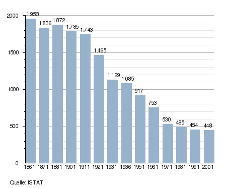
Bevölkerung
Siehe auch
Einzelnachweise
Weblinks
- Homepage der Gemeinde (italienisch)
- Informationen bei comuni-italiani.it (italienisch)
 Gemeinden in der Provinz Turin (A–M) in der Region Piemont
Agliè | Airasca | Ala di Stura | Albiano d’Ivrea | Alice Superiore | Almese | Alpette | Alpignano | Andezeno | Andrate | Angrogna | Arignano | Avigliana | Azeglio | Bairo | Balangero | Baldissero Canavese | Baldissero Torinese | Balme | Banchette | Barbania | Bardonecchia | Barone Canavese | Beinasco | Bibiana | Bobbio Pellice | Bollengo | Borgaro Torinese | Borgiallo | Borgofranco d’Ivrea | Borgomasino | Borgone Susa | Bosconero | Brandizzo | Bricherasio | Brosso | Brozolo | Bruino | Brusasco | Bruzolo | Buriasco | Burolo | Busano | Bussoleno | Buttigliera Alta | Cafasse | Caluso | Cambiano | Campiglione-Fenile | Candia Canavese | Candiolo | Canischio | Cantalupa | Cantoira | Caprie | Caravino | Carema | Carignano | Carmagnola | Casalborgone | Cascinette d’Ivrea | Caselette | Caselle Torinese | Castagneto Po | Castagnole Piemonte | Castellamonte | Castelnuovo Nigra | Castiglione Torinese | Cavagnolo | Cavour | Cercenasco | Ceres | Ceresole Reale | Cesana Torinese | Chialamberto | Chianocco | Chiaverano | Chieri | Chiesanuova | Chiomonte | Chiusa di San Michele | Chivasso | Ciconio | Cintano | Cinzano | Cirié | Claviere | Coassolo Torinese | Coazze | Collegno | Colleretto Castelnuovo | Colleretto Giacosa | Condove | Corio | Cossano Canavese | Cuceglio | Cumiana | Cuorgnè | Druento | Exilles | Favria | Feletto | Fenestrelle | Fiano | Fiorano Canavese | Foglizzo | Forno Canavese | Frassinetto | Front | Frossasco | Garzigliana | Gassino Torinese | Germagnano | Giaglione | Giaveno | Givoletto | Gravere | Groscavallo | Grosso | Grugliasco | Ingria | Inverso Pinasca | Isolabella | Issiglio | Ivrea | La Cassa | La Loggia | Lanzo Torinese | Lauriano | Leinì | Lemie | Lessolo | Levone | Locana | Lombardore | Lombriasco | Loranzè | Lugnacco | Luserna San Giovanni | Lusernetta | Lusigliè | Macello | Maglione | Marentino | Massello | Mathi | Mattie | Mazzè | Meana di Susa | Mercenasco | Meugliano | Mezzenile | Mombello di Torino | Mompantero | Monastero di Lanzo | Moncalieri | Moncenisio | Montaldo Torinese | Montalenghe | Montalto Dora | Montanaro | Monteu da Po | Moriondo Torinese
Gemeinden in der Provinz Turin (N–V) in der Region PiemontNichelino | Noasca | Nole | Nomaglio | None | Novalesa | Oglianico | Orbassano | Orio Canavese | Osasco | Osasio | Oulx | Ozegna | Palazzo Canavese | Pancalieri | Parella | Pavarolo | Pavone Canavese | Pecco | Pecetto Torinese | Perosa Argentina | Perosa Canavese | Perrero | Pertusio | Pessinetto | Pianezza | Pinasca | Pinerolo | Pino Torinese | Piobesi Torinese | Piossasco | Piscina | Piverone | Poirino | Pomaretto | Pont-Canavese | Porte | Pragelato | Prali | Pralormo | Pramollo | Prarostino | Prascorsano | Pratiglione | Quagliuzzo | Quassolo | Quincinetto | Reano | Ribordone | Riva presso Chieri | Rivalba | Rivalta di Torino | Rivara | Rivarolo Canavese | Rivarossa | Rivoli | Robassomero | Rocca Canavese | Roletto | Romano Canavese | Ronco Canavese | Rondissone | Rorà | Rosta | Roure | Rubiana | Rueglio | Salassa | Salbertrand | Salerano Canavese | Salza di Pinerolo | Samone | San Benigno Canavese | San Carlo Canavese | San Colombano Belmonte | San Didero | San Francesco al Campo | San Germano Chisone | San Gillio | San Giorgio Canavese | San Giorio di Susa | San Giusto Canavese | San Martino Canavese | San Maurizio Canavese | San Mauro Torinese | San Pietro Val Lemina | San Ponso | San Raffaele Cimena | San Sebastiano da Po | San Secondo di Pinerolo | Sangano | Sant’Ambrogio di Torino | Sant’Antonino di Susa | Santena | Sauze d’Oulx | Sauze di Cesana | Scalenghe | Scarmagno | Sciolze | Sestriere | Settimo Rottaro | Settimo Torinese | Settimo Vittone | Sparone | Strambinello | Strambino | Susa | Tavagnasco | Turin | Torrazza Piemonte | Torre Canavese | Torre Pellice | Trana | Trausella | Traversella | Traves | Trofarello | Usseaux | Usseglio | Vaie | Val della Torre | Valgioie | Vallo Torinese | Valperga | Valprato Soana | Varisella | Vauda Canavese | Venaria Reale | Venaus | Verolengo | Verrua Savoia | Vestignè | Vialfrè | Vico Canavese | Vidracco | Vigone | Villafranca Piemonte | Villanova Canavese | Villar Dora | Villar Focchiardo | Villar Pellice | Villar Perosa | Villarbasse | Villareggia | Villastellone | Vinovo | Virle Piemonte | Vische | Vistrorio | Viù | Volpiano | Volvera


Wikimedia Foundation.