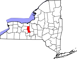
- Seneca County (New York)
-
Verwaltung US-Bundesstaat: New York Verwaltungssitz: Ovid und Waterloo Gründung: 1804 Gebildet aus: Cayuga County Vorwahl: 001 315 Demographie Einwohner: 33.342 (2000) Bevölkerungsdichte: 49,6 Einwohner/km² Geographie Fläche gesamt: 842 km² Wasserfläche: 170 km² Karte Website: www.co.seneca.ny.us Seneca County[1] ist ein County im US-Bundesstaat New York der Vereinigten Staaten von Amerika. Bei der Volkszählung im Jahr 2000 hatte das County 33.342 Einwohner und eine Bevölkerungsdichte von 40 Einwohner pro Quadratkilometer. Der Verwaltungssitz (County Seat) ist Ovid und Waterloo.
Inhaltsverzeichnis
Geschichte
Das County wurde 1804 gebildet und nach den Seneca-Indianern benannt.
Geografie
Das County hat eine Fläche von 1.011 Quadratkilometern, wovon 170 Quadratkilometer Wasserfläche sind.
Städte und Ortschaften
- Covert
- Fayette
- Interlaken
- Junius
- Lodi
- Ovid
- Romulus
- Seneca Falls
- Tyre
- Varick
- Waterloo
Einzelnachweise
- ↑ GNIS-ID: 974147. Abgerufen am 22. Februar 2011 (englisch).
Weblinks
-
 Commons: Seneca County, New York – Sammlung von Bildern, Videos und Audiodateien
Liste der Countys in New York
Albany | Allegany | Bronx | Broome | Cattaraugus | Cayuga | Chautauqua | Chemung | Chenango | Clinton | Columbia | Cortland | Delaware | Dutchess | Erie | Essex | Franklin | Fulton | Genesee | Greene | Hamilton | Herkimer | Jefferson | Kings (Brooklyn) | Lewis | Livingston | Madison | Monroe | Montgomery | Nassau | New York (Manhattan) | Niagara | Oneida | Onondaga | Ontario | Orange | Orleans | Oswego | Otsego | Putnam | Queens | Rensselaer | Richmond (Staten Island) | Rockland | Saratoga | Schenectady | Schoharie | Schuyler | Seneca | St. Lawrence | Steuben | Suffolk | Sullivan | Tioga | Tompkins | Ulster | Warren | Washington | Wayne | Westchester | Wyoming | Yates
Wikimedia Foundation.
Schlagen Sie auch in anderen Wörterbüchern nach:
Seneca County, New York — Infobox U.S. County county = Seneca County state = New York map size = 250 founded = 1804 seat = Ovid and Waterloo [ [http://www.co.seneca.ny.us/history/County%20Seat%20Story.doc The County Seat Story] ] | area total sq mi =325 area water sq mi… … Wikipedia
National Register of Historic Places listings in Seneca County, New York — Location of Seneca County in New York Ma … Wikipedia
Seneca Falls (New York) — Seneca Falls … Deutsch Wikipedia
Seneca Lake (New York) — Infobox lake lake name = Seneca Lake image lake = Seneca Lake Sampson.jpg caption lake = View in the early evening from Sampson State Park in Romulus, New York image bathymetry = |caption bathymetry = location = Finger Lakes, New York coords =… … Wikipedia
Seneca Knolls, New York — Infobox Settlement official name = Seneca Knolls, New York settlement type = CDP nickname = motto = imagesize = image caption = image |pushpin pushpin label position = pushpin map caption =Location within the state of New York pushpin mapsize =… … Wikipedia
County Route 41 (Onondaga County, New York) — County Route 41 Route information Length: 6.20 mi[1] … Wikipedia
County Route 236 (Onondaga County, New York) — County Route 236 Route information Length: 5.12 mi[2] (8.24 km) … Wikipedia
County Route 574 (Erie County, New York) — County Route 574 Jamison Road Map of the Buffalo area with CR 574 … Wikipedia
Schuyler County, New York — Infobox U.S. County county = Schuyler County state = New York map size = 250 founded = 1854 seat = Watkins Glen | area total sq mi =342 area water sq mi =14 area percentage = 3.95% census yr = 2000 pop = 19224 density km2 =23 web = |Schuyler… … Wikipedia
Wayne County, New York — Infobox U.S. County county = Wayne County state = New York map size = 225 founded = 1823 seat = Lyons motto = | area total sq mi =1384 area land sq mi =604 area water sq mi =780 area percentage = census yr = 2000 pop = 93765 density km2 =60 web … Wikipedia


