- Lewis County (New York)
-
Verwaltung US-Bundesstaat: New York Verwaltungssitz: Lowville Adresse des
Verwaltungssitzes:Lewis County Court House
Lowville, NY 13367Gründung: 28. März 1805 Gebildet aus: Oneida County Vorwahl: 001 315 Demographie Einwohner: 26.944 (2000) Bevölkerungsdichte: 8,2 Einwohner/km² Geographie Fläche gesamt: 3.341 km² Wasserfläche: 37 km² Karte 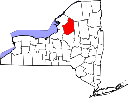
Website: www.lewiscountyny.org Lewis County[1] ist ein County im Bundesstaat New York der Vereinigten Staaten von Amerika. Bei der Volkszählung im Jahr 2000 hatte das County 26.944 Einwohner und eine Bevölkerungsdichte von 8 Einwohner pro Quadratkilometer. Der Verwaltungssitz (County Seat) ist Lowville.
Inhaltsverzeichnis
Geschichte
Das County wurde am 28. März 1805 aus Oneida County gebildet und benannt nach Morgan Lewis, einem Gouverneur New Yorks von 1804 bis 1807.
Geografie
Das County hat eine Fläche von 3.341 Quadratkilometern, wovon 37 Quadratkilometer Wasserfläche sind. Lewis County grenzt im Norden an St. Lawrence County, im Osten an Herkimer County, im Süden an Oneida County und im Westen an Oswego County und Jefferson County.
Städte und Ortschaften
- Castorland
- Constableville
- Copenhagen
- Croghan
- Denmark
- Diana
- Greig
- Harrisburg
- Harrisville
- Lewis
- Leyden
- Lowville
- Lyons Falls
- Lyonsdale
- Martinsburg
- Montague
- New Bremen
- Osceola
- Pinckney
- Port Leyden
- Turin
- Watson
- West Turin
Einzelnachweise
- ↑ GNIS-ID: 974123. Abgerufen am 22. Februar 2011 (englisch).

Liste der Countys in New York
Albany | Allegany | Bronx | Broome | Cattaraugus | Cayuga | Chautauqua | Chemung | Chenango | Clinton | Columbia | Cortland | Delaware | Dutchess | Erie | Essex | Franklin | Fulton | Genesee | Greene | Hamilton | Herkimer | Jefferson | Kings (Brooklyn) | Lewis | Livingston | Madison | Monroe | Montgomery | Nassau | New York (Manhattan) | Niagara | Oneida | Onondaga | Ontario | Orange | Orleans | Oswego | Otsego | Putnam | Queens | Rensselaer | Richmond (Staten Island) | Rockland | Saratoga | Schenectady | Schoharie | Schuyler | Seneca | St. Lawrence | Steuben | Suffolk | Sullivan | Tioga | Tompkins | Ulster | Warren | Washington | Wayne | Westchester | Wyoming | Yates
Wikimedia Foundation.
Schlagen Sie auch in anderen Wörterbüchern nach:
Lewis, Lewis County, New York — There is another Town of Lewis in Essex County, New York. Infobox Settlement official name = Lewis, New York settlement type = Town nickname = motto = imagesize = image caption = image |pushpin pushpin label position = pushpin map caption… … Wikipedia
Lewis County, New York — Infobox U.S. County county = Lewis County state = New York map size = 250 founded = 1805 seat = Lowville | area total sq mi =1290 area land sq mi =1275 area water sq mi =14 area percentage = 1.12% census yr = 2000 pop = 26944 cow pop = 50000… … Wikipedia
National Register of Historic Places listings in Lewis County, New York — Location of Lewis County in New York Map of … Wikipedia
Lewis, Essex County, New York — There is another Town of Lewis in Lewis County, New York. Infobox Settlement official name = Lewis, New York settlement type = Town nickname = motto = imagesize = image caption = image |pushpin pushpin label position = pushpin map caption… … Wikipedia
Oneida County, New York — Location in the state of New York … Wikipedia
Jefferson County, New York — Location in the state of New York … Wikipedia
Herkimer County, New York — Infobox U.S. County county = Herkimer County state = New York founded = 1791 seat = Herkimer | area total sq mi =1458 area water sq mi =47 area percentage = 3.23% census yr = 2000 pop = 64427 density km2 =18 web = www.herkimercounty.org |Herkimer … Wikipedia
Richmond County (New York) — Verwaltung US Bundesstaat: New York Verwaltungssitz: Adresse des Verwaltungssitzes: Gründung: 1683 … Deutsch Wikipedia
St. Lawrence County, New York — Seal … Wikipedia
Oswego County, New York — Seal … Wikipedia
Lewis County (New York)

18+
© Academic, 2000-2026
- Kontaktieren Sie uns: Unterstützung, Werbung
Wörterbücher Export, schritte mit PHP, Joomla, Drupal, WordPress, MODx.