- Steuben County (New York)
-
Verwaltung US-Bundesstaat: New York Verwaltungssitz: Bath Adresse des
Verwaltungssitzes:3 East Pulteney Square
Bath, NY 14810Gründung: 18. März 1796 Gebildet aus: Ontario County Vorwahl: 001 607 Demographie Einwohner: 98.726 (2000) Bevölkerungsdichte: 27,4 Einwohner/km² Geographie Fläche gesamt: 3.637 km² Wasserfläche: 30 km² Karte 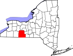
Website: www.steubencony.org Steuben County[1] ist ein County im Bundesstaat New York der Vereinigten Staaten von Amerika. Bei der Volkszählung im Jahr 2000 hatte das County 98.726 Einwohner und eine Bevölkerungsdichte von 27 Einwohner pro Quadratkilometer. Der Verwaltungssitz (County Seat) ist Bath.
Inhaltsverzeichnis
Geschichte
Das County wurde zu Ehren des aus Preußen stammenden Generals Friedrich Wilhelm von Steuben benannt.
Geografie
Das County hat eine Fläche von 3.637 Quadratkilometern, wovon 30 Quadratkilometer Wasserfläche sind.
Städte und Ortschaften
- Addison
- Almond
- Arkport
- Avoca
- Bath
- Bradford
- Cameron
- Campbell
- Canisteo (Stadt)
- Canisteo (Dorf)
- Caton
- Cohocton
- Corning
- Dansville
- Erwin
- Fremont
- Gang Mills
- Greenwood
- Hammondsport
- Hartsville
- Hornby
- Hornell
- Hornellsville
- Howard
- Jasper
- Lindley
- North Hornell
- Painted Post
- Prattsburgh
- Pulteney
- Rathbone
- Riverside
- Savona
- South Corning
- Thurston
- Troupsburg
- Tuscarora
- Urbana
- Wayland
- Wayne
- West Union
- Wheeler
- Woodhull
Einzelnachweise
- ↑ GNIS-ID: 974148. Abgerufen am 22. Februar 2011 (englisch).
Weblinks

Liste der Countys in New York
Albany | Allegany | Bronx | Broome | Cattaraugus | Cayuga | Chautauqua | Chemung | Chenango | Clinton | Columbia | Cortland | Delaware | Dutchess | Erie | Essex | Franklin | Fulton | Genesee | Greene | Hamilton | Herkimer | Jefferson | Kings (Brooklyn) | Lewis | Livingston | Madison | Monroe | Montgomery | Nassau | New York (Manhattan) | Niagara | Oneida | Onondaga | Ontario | Orange | Orleans | Oswego | Otsego | Putnam | Queens | Rensselaer | Richmond (Staten Island) | Rockland | Saratoga | Schenectady | Schoharie | Schuyler | Seneca | St. Lawrence | Steuben | Suffolk | Sullivan | Tioga | Tompkins | Ulster | Warren | Washington | Wayne | Westchester | Wyoming | Yates

Wikimedia Foundation.