- Madison County (New York)
-
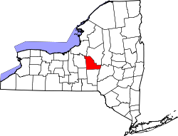
Verwaltung US-Bundesstaat: New York Verwaltungssitz: Wampsville Gründung: 21. März 1806 Gebildet aus: Chenango County Vorwahl: 001 315 Demographie Einwohner: 69.441 (2000) Bevölkerungsdichte: 40,9 Einwohner/km² Geographie Fläche gesamt: 1.713 km² Wasserfläche: 15 km² Karte Website: www.madisoncounty.org Madison County[1] ist ein County im Bundesstaat New York der Vereinigten Staaten von Amerika. Bei der Volkszählung im Jahr 2000 hatte das County 69.441 Einwohner und eine Bevölkerungsdichte von 41 Einwohner pro Quadratkilometer. Der Verwaltungssitz (County Seat) ist Wampsville.
Inhaltsverzeichnis
Geschichte
Das County wurde am 21. März 1806 aus Chenango County gebildet. Benannt wurde es nach James Madison, dem 4. Präsident der USA.
Geografie
Das County hat eine Fläche von 1.713 Quadratkilometern, wovon 15 Quadratkilometer Wasserfläche sind.
Städte und Ortschaften
- Bridgeport
- Brookfield
- Canastota
- Cazenovia
- Chittenango
- DeRuyter
- Eaton
- Fenner (New York)
- Georgetown
- Hamilton
- Lebanon
- Lenox
- Lincoln
- Madison
- Morrisville
- Munnsville
- Nelson
- Oneida
- Smithfield
- Stockbridge
- Sullivan
- Wampsville
Einzelnachweise
- ↑ GNIS-ID: 974125. Abgerufen am 22. Februar 2011 (englisch).
Liste der Countys in New York
Albany | Allegany | Bronx | Broome | Cattaraugus | Cayuga | Chautauqua | Chemung | Chenango | Clinton | Columbia | Cortland | Delaware | Dutchess | Erie | Essex | Franklin | Fulton | Genesee | Greene | Hamilton | Herkimer | Jefferson | Kings (Brooklyn) | Lewis | Livingston | Madison | Monroe | Montgomery | Nassau | New York (Manhattan) | Niagara | Oneida | Onondaga | Ontario | Orange | Orleans | Oswego | Otsego | Putnam | Queens | Rensselaer | Richmond (Staten Island) | Rockland | Saratoga | Schenectady | Schoharie | Schuyler | Seneca | St. Lawrence | Steuben | Suffolk | Sullivan | Tioga | Tompkins | Ulster | Warren | Washington | Wayne | Westchester | Wyoming | Yates
Wikimedia Foundation.

