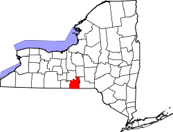
- Tioga County (New York)
-
Verwaltung US-Bundesstaat: New York Verwaltungssitz: Owego Gründung: 16. Februar 1791 Gebildet aus: Montgomery County Demographie Einwohner: 51.784 (2000) Bevölkerungsdichte: 38,6 Einwohner/km² Geographie Fläche gesamt: 1.354 km² Wasserfläche: 11 km² Karte Website: www.tiogacountyny.com Tioga County[1] ist ein County im Bundesstaat New York der Vereinigten Staaten von Amerika. Bei der Volkszählung im Jahr 2000 hatte das County 51.784 Einwohner und eine Bevölkerungsdichte von 39 Einwohner pro Quadratkilometer. Der Verwaltungssitz (County Seat) ist Owego.
Geografie
Das County hat eine Fläche von 1.354 Quadratkilometern, wovon 11 Quadratkilometer Wasserfläche sind.
Städte und Ortschaften
- Apalachin
- Barton
- Berkshire
- Candor
- Newark Valley
- Nichols
- Owego (Village)
- Owego (Town)
- Richford
- Spencer
- Tioga
- Waverly
Einzelnachweise
- ↑ GNIS-ID: 974151. Abgerufen am 22. Februar 2011 (englisch).
Liste der Countys in New York
Albany | Allegany | Bronx | Broome | Cattaraugus | Cayuga | Chautauqua | Chemung | Chenango | Clinton | Columbia | Cortland | Delaware | Dutchess | Erie | Essex | Franklin | Fulton | Genesee | Greene | Hamilton | Herkimer | Jefferson | Kings (Brooklyn) | Lewis | Livingston | Madison | Monroe | Montgomery | Nassau | New York (Manhattan) | Niagara | Oneida | Onondaga | Ontario | Orange | Orleans | Oswego | Otsego | Putnam | Queens | Rensselaer | Richmond (Staten Island) | Rockland | Saratoga | Schenectady | Schoharie | Schuyler | Seneca | St. Lawrence | Steuben | Suffolk | Sullivan | Tioga | Tompkins | Ulster | Warren | Washington | Wayne | Westchester | Wyoming | Yates
Wikimedia Foundation.
Schlagen Sie auch in anderen Wörterbüchern nach:
Tioga County, New York — Infobox U.S. County county = Tioga County state = New York map size = 225 founded = 1791 seat = Owego | area total sq mi =523 area land sq mi =519 area water sq mi =4 area percentage = 0.81% census yr = 2000 pop = 51784 density km2 =39 web =… … Wikipedia
List of county routes in Tioga County, New York — County routes in Tioga County, New York, are signed with the Manual on Uniform Traffic Control Devices standard yellow on blue pentagon shield. Even numbered routes are east–west in direction, while odd numbered routes are north–south. County… … Wikipedia
Tioga County, New York — Comté de Tioga (New York) Pour les articles homonymes, voir Comté de Tioga. Comté de Tioga (Tioga County) … Wikipédia en Français
National Register of Historic Places listings in Tioga County, New York — Location of Tioga County in New York Map of … Wikipedia
Waverly, Tioga County, New York — Another Waverly is a town in Franklin County, New York . Infobox Settlement official name = Waverly, New York settlement type = Village nickname = motto = imagesize = image caption = image |pushpin pushpin label position = pushpin map caption… … Wikipedia
County Route 115 (Tompkins County, New York) — County Route 115 Route information Maintained by Tompkins County Highway Division Length: 12.90 mi … Wikipedia
Chemung County, New York — Seal … Wikipedia
Broome County, New York — Infobox U.S. County county = Broome County state = New York map size = 250 founded = 1806 seat = Binghamton | area total sq mi =715 area land sq mi =707 area water sq mi =9 area percentage = 1.21% census yr = 2000 pop = 200536 density km2 =110… … Wikipedia
Cortland County, New York — Seal … Wikipedia
Richmond County (New York) — Verwaltung US Bundesstaat: New York Verwaltungssitz: Adresse des Verwaltungssitzes: Gründung: 1683 … Deutsch Wikipedia

