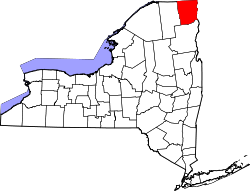
- Clinton County (New York)
-
Verwaltung US-Bundesstaat: New York Verwaltungssitz: Plattsburgh Gründung: 1788 Gebildet aus: Washington County Vorwahl: 001 518 Demographie Einwohner: 79.894 (2000) Bevölkerungsdichte: 29,7 Einwohner/km² Geographie Fläche gesamt: 2.895 km² Wasserfläche: 204 km² Karte Website: www.clintoncountygov.com Clinton County[1] ist ein County im Bundesstaat New York der Vereinigten Staaten von Amerika. Bei der Volkszählung im Jahr 2000 hatte das County 79.894 Einwohner und eine Bevölkerungsdichte von 30 Einwohnern pro Quadratkilometer. Der Verwaltungssitz (County Seat) ist Plattsburgh.
Inhaltsverzeichnis
Geschichte
Clinton County wurde 1788 aus Washington County gebildet und nach George Clinton benannt.
Geographie
Das County hat eine Fläche von 2895 Quadratkilometern, wovon 204 Quadratkilometer Wasserfläche sind. Clinton County grenzt im Norden an Kanada, im Osten an Vermont, im Süden an Essex County und im Westen an Franklin County.
Städte und Ortschaften
- Altona
- Au Sable Forks
- Au Sable
- Beekmantown
- Black Brook
- Champlain Town
- Champlain Village
- Chazy
- Clinton
- Cumberland Head
- Dannemora
- Ellenburg
- Keeseville
- Lyon Mountain
- Mooers
- Morrisonville
- Parc
- Peru
- Plattsburgh West
- Plattsburgh
- Redford
- Rouses Point
- Saranac
- Schuyler Falls
Einzelnachweise
- ↑ GNIS-ID: 974108. Abgerufen am 22. Februar 2011 (englisch).
Liste der Countys in New York
Albany | Allegany | Bronx | Broome | Cattaraugus | Cayuga | Chautauqua | Chemung | Chenango | Clinton | Columbia | Cortland | Delaware | Dutchess | Erie | Essex | Franklin | Fulton | Genesee | Greene | Hamilton | Herkimer | Jefferson | Kings (Brooklyn) | Lewis | Livingston | Madison | Monroe | Montgomery | Nassau | New York (Manhattan) | Niagara | Oneida | Onondaga | Ontario | Orange | Orleans | Oswego | Otsego | Putnam | Queens | Rensselaer | Richmond (Staten Island) | Rockland | Saratoga | Schenectady | Schoharie | Schuyler | Seneca | St. Lawrence | Steuben | Suffolk | Sullivan | Tioga | Tompkins | Ulster | Warren | Washington | Wayne | Westchester | Wyoming | Yates
Wikimedia Foundation.

