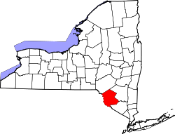
- Sullivan County (New York)
-
Verwaltung US-Bundesstaat: New York Verwaltungssitz: Monticello Adresse des
Verwaltungssitzes:3 East Pulteney Square
Bath, NY 14810Gründung: 27. März 1809 Gebildet aus: Ulster County Demographie Einwohner: 73.966 (2000) Bevölkerungsdichte: 29,4 Einwohner/km² Geographie Fläche gesamt: 2.582 km² Wasserfläche: 70 km² Karte Website: www.co.sullivan.ny.us Sullivan County[1] ist ein County im Bundesstaat New York der Vereinigten Staaten von Amerika. Bei der Volkszählung im Jahr 2000 hatte das County 73.966 Einwohner und eine Bevölkerungsdichte von 29 Einwohner pro Quadratkilometer. Der Verwaltungssitz (County Seat) ist Monticello.
Inhaltsverzeichnis
Geografie
Das County hat eine Fläche von 2.582 Quadratkilometern, wovon 70 Quadratkilometer Wasserfläche sind.
Städte und Ortschaften
- Bethel
- Bloomingburg
- Callicoon
- Cochecton
- Delaware
- Fallsburg
- Forestburgh
- Fremont
- Highland
- Jeffersonville
- Liberty
- Livingston Manor
- Lumberland
- Mamakating
- Monticello
- Narrowsburg
- Neversink
- Rock Hill
- Rockland
- Roscoe
- Smallwood
- South Fallsburg
- Thompson
- Tusten
- Woodridge
- Wurtsboro
Sehenswürdigkeiten
- Die Anshei Glen Wild Synagogue von 1923 in der nicht statuierten Siedlung Glen Wild
Einzelnachweise
- ↑ GNIS-ID: 974150. Abgerufen am 22. Februar 2011 (englisch).
Liste der Countys in New York
Albany | Allegany | Bronx | Broome | Cattaraugus | Cayuga | Chautauqua | Chemung | Chenango | Clinton | Columbia | Cortland | Delaware | Dutchess | Erie | Essex | Franklin | Fulton | Genesee | Greene | Hamilton | Herkimer | Jefferson | Kings (Brooklyn) | Lewis | Livingston | Madison | Monroe | Montgomery | Nassau | New York (Manhattan) | Niagara | Oneida | Onondaga | Ontario | Orange | Orleans | Oswego | Otsego | Putnam | Queens | Rensselaer | Richmond (Staten Island) | Rockland | Saratoga | Schenectady | Schoharie | Schuyler | Seneca | St. Lawrence | Steuben | Suffolk | Sullivan | Tioga | Tompkins | Ulster | Warren | Washington | Wayne | Westchester | Wyoming | Yates
Wikimedia Foundation.
Schlagen Sie auch in anderen Wörterbüchern nach:
Sullivan County, New York — Infobox U.S. County county = Sullivan County state = New York map size = 225 founded = 1809 seat = Monticello | area total sq mi =997 area water sq mi =27 area percentage = 2.72% census yr = 2000 pop = 73966 density km2 =29 web =… … Wikipedia
County Route 149 (Sullivan County, New York) — County Route 149 Map of Sullivan County and vicinity with CR 149 highlighted in red … Wikipedia
County Route 168 (Sullivan County, New York) — County Route 168 Route information … Wikipedia
List of county routes in Sullivan County, New York — Contents 1 Routes 1–49 1.1 Barryville to Claryville (11–19) 1.2 Barryville to Narrowsburg (21–26) … Wikipedia
National Register of Historic Places listings in Sullivan County, New York — Location of Sullivan County in New York … Wikipedia
Fremont, Sullivan County, New York — Another Fremont is a town in Steuben County, New York. Infobox Settlement official name = Fremont, New York settlement type = Town nickname = motto = imagesize = image caption = image |pushpin pushpin label position = pushpin map caption… … Wikipedia
Highland, Sullivan County, New York — For the community in Ulster County, see Highland, Ulster County, New York. Barryville is a town in Sullivan County, New York, United States. The population was 2,404 at the 2000 census. The town s name notes its location on elevated ground north… … Wikipedia
Delaware County, New York — Location in the state of New York … Wikipedia
Richmond County (New York) — Verwaltung US Bundesstaat: New York Verwaltungssitz: Adresse des Verwaltungssitzes: Gründung: 1683 … Deutsch Wikipedia
Fremont, Steuben County, New York — Another Fremont is a town in Sullivan County, New York. Infobox Settlement official name = Fremont, New York settlement type = Town nickname = motto = imagesize = image caption = image |pushpin pushpin label position = pushpin map caption… … Wikipedia

