- South Lanarkshire
-
South Lanarkshire
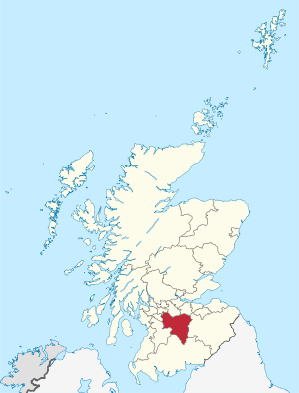
Siorrachd Lannraig a DeasVerwaltungssitz Hamilton Fläche 1.772 km² (11.) Einwohner 311.880 (2010)[1] (5.) ISO 3166-2 GB-SLK ONS-Code 00RF Website www.southlanarkshire.gov.uk South Lanarkshire (gälisch Siorrachd Lannraig a Deas) ist eine von 32 Unitary Authorities in Schottland. Sie umfasst den südlichen Teil der traditionellen Grafschaft Lanarkshire und grenzt an Scottish Borders, East Renfrewshire, Dumfries and Galloway, East Ayrshire, North Ayrshire, Glasgow und North Lanarkshire.
Inhaltsverzeichnis
Orte
- Auchenheath
- Blackwood
- Blantyre
- Cambuslang
- Carluke
- Carstairs
- Coalburn
- East Kilbride
- Hamilton
- Kirkmuirhill
- Lanark
- Larkhall
- Lesmahagow
- New Lanark
- Rutherglen
- Strathaven
- Stonehouse
Sehenswürdigkeiten
- Clyde Valley
- Craignethan Castle
- Falls of Clyde
- New Lanark (Weltkulturerbe)
- Cadzow Castle
- Chatlerhault Country Park
- David Livingstone Centre
Politik
Der Council von South Lanarkshire umfasst 67 Sitze, die sich wie folgt auf die Parteien verteilen:[2]
Partei Sitze Scottish Labour 31 Scottish National Party 23 Scottish Conservatives 8 Unabhängig 3 Liberal Democrats 2 Einzelnachweise
- ↑ Amtliche Einwohnerzahlen 2010
- ↑ South Lanarkshire Council: http://www.southlanarkshire.gov.uk/portal/page/portal/EXTERNAL_WEBSITE_DEVELOPMENT/SLC_ONLINE_HOME/SLC_COUNCIL/COUNCILLORS_COMMITTEES Councillors, committees (Abgerufen am 14. April 2008)
Aberdeen | Aberdeenshire | Angus | Argyll and Bute | Clackmannanshire | Dumfries and Galloway | Dundee | East Ayrshire | East Dunbartonshire | East Lothian | East Renfrewshire | Edinburgh | Falkirk | Fife | Glasgow | Highland | Inverclyde | Midlothian | Moray | Äußere Hebriden | North Ayrshire | North Lanarkshire | Orkney | Perth and Kinross | Renfrewshire | Scottish Borders | Shetland | South Ayrshire | South Lanarkshire | Stirling | West Dunbartonshire | West Lothian
Wikimedia Foundation.
Schlagen Sie auch in anderen Wörterbüchern nach:
South Lanarkshire — / Siorrachd Lannraig a Deas Consejo unitario del Reino Unido Localización de South Lanarkshire en Escocia … Wikipedia Español
South Lanarkshire — [ saʊθ lænəkʃɪə], Verwaltungs Distrikt in Schottland, 1 771 km2, 307 100 Einwohner; Verwaltungssitz ist Hamilton … Universal-Lexikon
South Lanarkshire — infobox Scotland council area Council= South Lanarkshire Siorrachd Lannraig a Deas SizeRank= 11th Size= 1,772 km² Water= ? AdminHQ= Hamilton ISO= GB SLK ONS= 00RF PopulationRank= 5th PopulationDate= 2004 Population= 305,410 PopulationDensity=172… … Wikipedia
South Lanarkshire — Pour les articles homonymes, voir Lanark (homonymie). South Lanarkshire Géographie … Wikipédia en Français
South Lanarkshire — ▪ council area, Scotland, United Kingdom council area, south central Scotland, encompassing Clydesdale the valley of the River Clyde and the surrounding lowlands and uplands. South Lanarkshire extends from the heavily urbanized southern… … Universalium
South Lanarkshire — Sp Pietų Lãnarkšyras Ap South Lanarkshire L Škotijos adm. sr., Jungtinė Karalystė … Pasaulio vietovardžiai. Internetinė duomenų bazė
South Lanarkshire — Admin ASC 2 Code Orig. name South Lanarkshire Country and Admin Code GB.SCT.W5 GB … World countries Adminstrative division ASC I-II
South Lanarkshire Council election, 2007 — Elections to South Lanarkshire Council were held on the May 3 2007 the same day as the other Scottish local government elections and the Scottish Parliament general election. The election was the first one using 20 new wards created as a results… … Wikipedia
South Lanarkshire (UK Parliament constituency) — UK former constituency infobox Name = South Lanarkshire Type = County Year = 1868 Abolition = 1918 members = OneSouth Lanarkshire was a county constituency of the House of Commons of the Parliament of the United Kingdom (Westminster) from 1868 to … Wikipedia
South Lanarkshire — /saʊθ ˈlænəkʃɪə/ (say sawth lanuhkshear), / ʃə/ (say shuh) noun an administrative district in southern Scotland; part of the former county of Lanarkshire which was included in Strathclyde in 1975; formed as a unitary district in 1996. 1772 km2.… …