- Inverclyde
-
Inverclyde
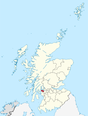
Inbhir ChluaidhVerwaltungssitz Greenock Fläche 160 km² (29.) Einwohner 79.770 (2010)[1] (28.) ISO 3166-2 GB-IVC ONS-Code 00QU Website www.inverclyde.gov.uk Inverclyde (gälisch Inbhir Chluaidh) ist eine von 32 Unitary Authorities in Schottland. Sie liegt am nördlichen Ende des Firth of Clyde und grenzt an Renfrewshire und North Ayrshire. Das Gebiet dieses Verwaltungsbezirks liegt in der traditionellen Grafschaft Renfrewshire.
Inhaltsverzeichnis
Orte
- Gourock
- Greenock
- Inverkip
- Kilmacolm
- Port Glasgow
- Wemyss Bay
Politik
Der Council von Inverclyde umfasst 20 Sitze, die sich wie folgt auf die Parteien verteilen:[2]
Partei Sitze Liberal Democrats 4 Scottish National Party 5 Scottish Labour 9 Scottish Conservatives 1 Unabhängig 1 Weblinks
Commons: Inverclyde – Sammlung von Bildern, Videos und AudiodateienEinzelnachweise
- ↑ Amtliche Einwohnerzahlen 2010
- ↑ Inverclyde Council: http://www.inverclyde.gov.uk/Category.aspx?catid=367 Councillors (Abgerufen am 13. April 2008)
Aberdeen | Aberdeenshire | Angus | Argyll and Bute | Clackmannanshire | Dumfries and Galloway | Dundee | East Ayrshire | East Dunbartonshire | East Lothian | East Renfrewshire | Edinburgh | Falkirk | Fife | Glasgow | Highland | Inverclyde | Midlothian | Moray | Äußere Hebriden | North Ayrshire | North Lanarkshire | Orkney | Perth and Kinross | Renfrewshire | Scottish Borders | Shetland | South Ayrshire | South Lanarkshire | Stirling | West Dunbartonshire | West Lothian
Wikimedia Foundation.
Schlagen Sie auch in anderen Wörterbüchern nach:
Inverclyde — / Inbhir Chluaidh Consejo unitario de Escocia Situación de Inverclyde en Escocia. Capital … Wikipedia Español
Inverclyde — [ɪnvə klaɪd], Verwaltungsgebiet in Schottland, an der Südküste des Firth of Clyde, mit den städtischen Siedlungen Gourock, Greenock, Port Glasgow und ihrem nahen Hinterland, 162 km2, 85 400 Einwohner, zu 68 % landwirtschaftlich genutzt. Zum 1.… … Universal-Lexikon
Inverclyde — infobox Scotland council area Council= Inverclyde Inbhir Chluaidh SizeRank= 29th Size= 160 km² Water= ? AdminHQ= Greenock ISO= GB IVC ONS= 00QU PopulationRank= 27th PopulationDate= 2004 Population= 82,432 PopulationDensity=515 / km²… … Wikipedia
Inverclyde — 55°54′N 4°45′W / 55.9, 4.75 … Wikipédia en Français
Inverclyde — ▪ council area, Scotland, United Kingdom council area, west central Scotland, lying entirely within the historic county of Renfrewshire. Inverclyde extends along the River Clyde and the Firth of Clyde on the north and encompasses an area of … Universalium
Inverclyde — Sp Inverkláidas Ap Inverclyde L Škotijos adm. sr., D. Britanija … Pasaulio vietovardžiai. Internetinė duomenų bazė
Inverclyde — Admin ASC 2 Code Orig. name Inverclyde Country and Admin Code GB.SCT.V4 GB … World countries Adminstrative division ASC I-II
Inverclyde (disambiguation) — Inverclyde is a council area of Scotland. It may also refer to: * Inverclyde (UK Parliament constituency) mdash; a constituency represented in the House of Commons of the United Kingdom ** Greenock and Inverclyde (UK Parliament constituency)… … Wikipedia
Inverclyde Royal Hospital — Infobox Hospital Name = Inverclyde Royal Hospital Org/Group = NHS Greater Glasgow and Clyde Hospital Trust Caption = map type = latitude = longitude = Region = Greenock, Inverclyde State = Scotland Country = UK Coordinates = HealthCare = NHS Type … Wikipedia
Inverclyde Academy — Infobox UK school name = Inverclyde Academy size = latitude = longitude = dms = motto = motto pl = established = 2007 approx = closed = c approx = type = Comprehensive religion = president = head label = head = r head label = r head = chair label … Wikipedia