- Dumfries and Galloway
-
Dumfries and Galloway 
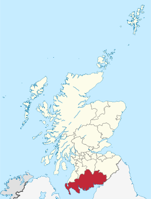
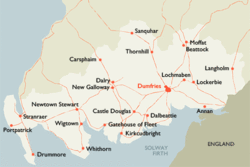
Verwaltungssitz Dumfries Fläche 6.426 km² (3.) Einwohner (2010) 148.190[1] (12.) ISO 3166-2 GB-DGY ONS-Code 00QH Website www.dumgal.gov.uk Dumfries and Galloway [dʌmˌfɹiːsənˈgæləweɪ] (gälisch Dùn Phris agus an Gall-Ghaidhealaibh) ist eine von 32 Unitary Authorities in Schottland. Im Norden grenzt sie an North Ayrshire, East Ayrshire und South Lanarkshire, im Osten an Scottish Borders und im Süden an die englische Grafschaft Cumbria. Sie liegt nördlich des Solway Firth und östlich der Irischen See.
Dumfries und Galloway umfasst drei traditionelle Grafschaften; im Osten Dumfriesshire, im Zentrum Kirkcudbrightshire und im Westen Wigtownshire. Die zwei letzteren werden zusammen auch als Galloway bezeichnet.
Nach Galloway wurden die Galloway-Rinder benannt.
Von 1975 bis 1996 bildete Dumfries and Galloway eine schottische Region.
Inhaltsverzeichnis
Geschichte
Die Region Dumfries und Galloway wurde 1975 aus den Grafschaften Dumfriesshire, Kirkcudbrightshire und Wigtownshire gebildet. Die Region war in vier Districts gegliedert:
- Annandale and Eskdale
- Nithsdale
- Stewartry
- Wigtown
1996 wurden die Regionen und Districts in Schottland abgeschafft und durch 32 Unitary Authorities ersetzt. Die vier Districts der Region Dumfries und Galloway wurden aufgelöst und aus der ganzen Region wurde die Unitary Authority Dumfries und Galloway gebildet.
Orte
- Ae
- Beattock
- Annan
- Caerlaverock
- Cairnryan
- Carsphairn
- Castle Douglas
- Castle Kennedy
- Creetown
- Dalbeattie
- Dalton
- Drumlanrig
- Drummore
- Dumfries
- Ecclefechan
- Eskdalemuir
- Gatehouse of Fleet
- Glenluce
- Gretna Green
- Kirkcolm
- Kirkcudbright
- Langholm
- Lochmaben
- Lockerbie
- Millhousebridge
- Moffat
- Moniaive
- Mull of Galloway
- New Abbey
- New Galloway
- New Luce
- Newton Stewart
- Portpatrick
- Ruthwell
- St. John's Town of Dalry
- Sanquhar
- Stranraer
- Thornhill
- Wanlockhead
- Whithorn
- Wigtown
Sehenswürdigkeiten
- Barsalloch Fort
- Caerlaverock Castle
- Cairnderry
- Cairnholy
- Corsewall Lighthouse
- Drumtroddan
- Galloway Forest Park
- Glenluce Abbey
- Kilmorie Stone
- Southern Upland Way
- Sweetheart Abbey
Persönlichkeiten
- Die Schauspielerin Ashley Jensen wurde 1969 in Annan geboren.
Politik
Der Council von Dumfries and Galloway umfasst 47 Sitze, die sich wie folgt auf die Parteien verteilen:[2]
Partei Sitze Scottish Conservatives 18 Scottish Labour 14 Scottish National Party 10 Liberal Democrats 3 Unabhängig 2 Weblinks
 Commons: Dumfries and Galloway – Sammlung von Bildern, Videos und Audiodateien
Einzelnachweise
- ↑ Amtliche Einwohnerzahlen 2010
- ↑ Dumfries and Galloway Council: http://www.dumgal.gov.uk/electionresults/default.aspx Local Government Election Results (Abgerufen am 13. April 2008)
Aberdeen | Aberdeenshire | Angus | Argyll and Bute | Clackmannanshire | Dumfries and Galloway | Dundee | East Ayrshire | East Dunbartonshire | East Lothian | East Renfrewshire | Edinburgh | Falkirk | Fife | Glasgow | Highland | Inverclyde | Midlothian | Moray | Äußere Hebriden | North Ayrshire | North Lanarkshire | Orkney | Perth and Kinross | Renfrewshire | Scottish Borders | Shetland | South Ayrshire | South Lanarkshire | Stirling | West Dunbartonshire | West Lothian
Wikimedia Foundation.
Schlagen Sie auch in anderen Wörterbüchern nach:
Dumfries And Galloway — Géographie Superficie Total % Eau 3e 6 426 km² ? % … Wikipédia en Français
Dumfries and galloway — Géographie Superficie Total % Eau 3e 6 426 km² ? % … Wikipédia en Français
Dumfries and Galloway — Géographie Superficie 3e Total 6426 km² % eau ? C … Wikipédia en Français
Dumfries and Galloway — Saltar a navegación, búsqueda Dumfries and Galloway es uno de los 32 condados de Escocia y limita con los condados de South Ayrshire, East Ayrshire y South Lanarkshire. Al sur, limita con el condado de Cumbria en Inglaterra. Además tiene contacto … Wikipedia Español
Dumfries and Galloway — [dʌm friːs ænd gæləweɪ riːdʒən], Verwaltungsgebiet in Südwestschottland, 6 439 km2, 147 300 Einwohner, Verwaltungssitz ist Dumfries; erstreckt sich vom Solway Firth in die Southern Uplands (bis 843 m über dem Meeresspiegel); im Küstentiefland… … Universal-Lexikon
Dumfries and Galloway — administrative division of S Scotland … English World dictionary
Dumfries and Galloway — See also: Dumfries and Galloway (UK Parliament constituency) Dumfries and Galloway Dumfries an Gallowa Dùn Phris is Gall Ghaidhealaibh Logo Location … Wikipedia
Dumfries and Galloway — a region in S Scotland. 143,667; 2460 sq. mi. (6371 sq. km). * * * ▪ council area, Scotland, United Kingdom council area of southwestern Scotland whose coast borders the Solway Firth, the Irish Sea, and the North Channel. It encompasses the … Universalium
Dumfries and Galloway — Admin ASC 2 Code Orig. name Dumfries and Galloway Country and Admin Code GB.SCT.U2 GB … World countries Adminstrative division ASC I-II
Dumfries and Galloway — Sp Damfrisas ir Gãlovėjus Ap Dumfries and Galloway L Škotijos adm. sr., Jungtinė Karalystė … Pasaulio vietovardžiai. Internetinė duomenų bazė

