- Clackmannanshire
-
Clackmannanshire
Siorrachd Chlach Mhannainn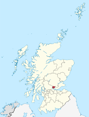
Verwaltungssitz Alloa Fläche 159 km² (30.) Einwohner (2005) 50.630[1] (29.) ISO 3166-2 GB-CLK ONS-Code 00QF Website www.clacks.gov.uk Clackmannanshire (traditionell) 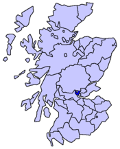
Clackmannanshire (gälisch Siorrachd Chlach Mhannainn) ist eine von 32 Unitary Authorities in Schottland. Sie ist die kleinste aller Verwaltungsbezirke und grenzt an Perth and Kinross, Stirling und Fife. Die wichtigsten Wirtschaftszweige sind Landwirtschaft, Bierbrauerei und Kohlebergbau.
Clackmannanshire ist auch eine traditionelle Grafschaft; als solche grenzt sie an Perthshire, Stirlingshire und Fife.
Inhaltsverzeichnis
Orte
- Alloa
- Alva
- Clackmannan
- Coalsnaughton
- Dollar
- Fishcross
- Menstrie
- Muckhart
- Sauchie
- Tillicoultry
- Tullibody
Sehenswürdigkeiten
- Alloa Tower
- Ben Cleuch
- Castle Campbell
- Gartmorn Dam
- Menstrie Castle
Politik
Der Council von Clackmannanshire umfasst 18 Sitze, die sich wie folgt auf die Parteien verteilen:[2]
Partei Sitze Scottish Labour 8 Scottish National Party 7 Liberal Democrats 1 Scottish Conservatives 1 Unabhängig 1 Einzelnachweise
- ↑ Amtliche Einwohnerzahlen 2010
- ↑ Clackmannanshire Council: http://www.clacks.gov.uk/council/ Council & Democracy (Abgerufen am 13. April 2008)

Aberdeen | Aberdeenshire | Angus | Argyll and Bute | Clackmannanshire | Dumfries and Galloway | Dundee | East Ayrshire | East Dunbartonshire | East Lothian | East Renfrewshire | Edinburgh | Falkirk | Fife | Glasgow | Highland | Inverclyde | Midlothian | Moray | Äußere Hebriden | North Ayrshire | North Lanarkshire | Orkney | Perth and Kinross | Renfrewshire | Scottish Borders | Shetland | South Ayrshire | South Lanarkshire | Stirling | West Dunbartonshire | West Lothian
Wikimedia Foundation.
Schlagen Sie auch in anderen Wörterbüchern nach:
Clackmannanshire — Siorrachd Chlach Mhannainn … Wikipedia
Clackmannanshire — / Siorrachd Chlach Mhannainn Consejo unitario de Escocia Situación de Clackmannanshire en Escocia … Wikipedia Español
Clackmannanshire — (spr. kläckmännenschĭr), Grafschaft im südlichen Schottland, die kleinste des Landes, von den Grafschaften Perth, Stirling und Fife umgeben, umfaßt 129 qkm (2,3 QM.), mit (1901) 32,019 Einw. (248 auf 1 qkm). Hauptort ist Clackmannan … Meyers Großes Konversations-Lexikon
Clackmannanshire — [klæk mænən], Verwaltungsgebiet in Schottland, 157 km2, 48 600 Einwohner; Verwaltungssitz ist Alloa … Universal-Lexikon
Clackmannanshire — CLACKMANNANSHIRE, a small county in the interior of Scotland, bounded on the north and north west by Perthshire, from which it is separated by the Ochil Hills; on the east, by the county of Fife; and on the south and south west, by the river… … A Topographical dictionary of Scotland
Clackmannanshire — 56°10′N 3°45′W / 56.167, 3.75 … Wikipédia en Français
Clackmannanshire — ▪ council area and historic county, Scotland, United Kingdom also called Clackmannan council area and historic county, east central Scotland, bounded on the southwest by the River Forth. The River Devon, flowing east west before turning… … Universalium
Clackmannanshire — Sp Klakmãnanšyras Ap Clackmannanshire L Škotijos adm. sr., Jungtinė Karalystė … Pasaulio vietovardžiai. Internetinė duomenų bazė
Clackmannanshire — Admin ASC 2 Code Orig. name Clackmannanshire Country and Admin Code GB.SCT.U1 GB … World countries Adminstrative division ASC I-II
Clackmannanshire and Dunblane (Scottish Parliament constituency) — Clackmannanshire and Dunblane Scottish Parliament county constituency 150px … Wikipedia
- Kontaktieren Sie uns: Unterstützung, Werbung
Clackmannanshire


18+
© Academic, 2000-2025
Wörterbücher Export, schritte mit PHP, Joomla, Drupal, WordPress, MODx.