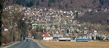
- Hranovnica
-
Hranovnica
Wappen Karte 

Hranovnica BasisdatenKraj: Prešovský kraj Okres: Poprad Region: Tatry Fläche: 32,661 km² Einwohner: 2.848 (31. Dez. 2010) Bevölkerungsdichte: 87,2 Einwohner je km² Höhe: 613 m n.m. Postleitzahl: 059 16 Telefonvorwahl: 0 52 Geographische Lage: 48° 59′ N, 20° 19′ O48.98888888888920.313888888889613Koordinaten: 48° 59′ 20″ N, 20° 18′ 50″ O Kfz-Kennzeichen: PP Gemeindekennziffer: 523518 StrukturGemeindeart: Gemeinde Verwaltung (Stand: März 2011)Bürgermeister: Martin Benko Adresse: Obecný úrad Hranovnica
Sládkovičova 398
059 16 HranovnicaWebpräsenz: www.hranovnica.sk Gemeindeinformation
auf portal.gov.skStatistikinformation
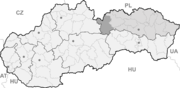
auf statistics.skHranovnica (deutsch Grenitz oder Gränitz, ungarisch Szepesvéghely - bis 1892 Grénic) ist eine Gemeinde im Okres Poprad innerhalb des Prešovský kraj in der Slowakei.
 Hranovnica
Geographie
Der Ort liegt im Tal des Flusses Hornád am Bach Vernársky potok, der nördlich in den Hornád mündet. Hranovnica befindet sich zwischen den Gebirgen Kozie chrbty im Norden und Niedere Tatra und Slowakisches Paradies im Süden. Der Ortskern befindet sich auf der Höhe von 613 m n.m. Poprad ist 10 km nach Norden und Spišská Nová Ves ist 27 km nach Südosten entfernt.
Geschichte
Hranovnica wurde zum ersten Mal 1294 als Granich erwähnt. Der Name ist wohl vom slawischen Wort granica (= Grenze) abgeleitet, wahrscheinlich wegen seiner Lage an der Grenze der Komitate Zips und Gemer. Im Mittelalter gehörte sie den Zisterzienser-Orden, der im Kloster Spišský Štiavnik ansässig war. Neben der Landwirtschaft war in dieser Zeit auch Bergbau getrieben. In den Jahren 1776–1945 war der Ort im Eigentum des Bistums Zips.
Heute sind die Haupteinnahmequellen Landwirtschaft- und Dienstsektor, der dank der Nähe der Nationalparks Niedere Tatra und Slowakisches Paradies sich entwickelt hat.
Weblinks
Batizovce (Botzdorf) | Gánovce (Gansdorf) | Gerlachov (Gerlsdorf) | Hozelec (Hohesalz) | Hôrka (Horke) | Hranovnica (Grenitz) | Jánovce (Johannsdorf) | Kravany (Kuhschwanz) | Liptovská Teplička (Zeplitschke) | Lučivná (Lautschburg) | Mengusovce (Mengsdorf) | Mlynica (Mühlenbach) | Nová Lesná (Neuwalddorf) | Poprad (Deutschendorf) | Spišská Teplica (Teplitz) | Spišské Bystré (Kuhbach) | Spišský Štiavnik (Schawnig) | Svit | Štôla (Stollen) | Štrba (Tschirm) | Šuňava (Schönau) | Švábovce (Schwabsdorf) | Tatranská Javorina (Uhrngarten) | Veľký Slavkov (Großschlagendorf) | Vernár (Wernsdorf) | Vikartovce (Weigsdorf) | Vydrník (Wiedrig) | Vysoké Tatry | Ždiar (Morgenröthe)


Wikimedia Foundation.