- Imathia
-
Präfektur Imathia
Νομός Ημαθίας
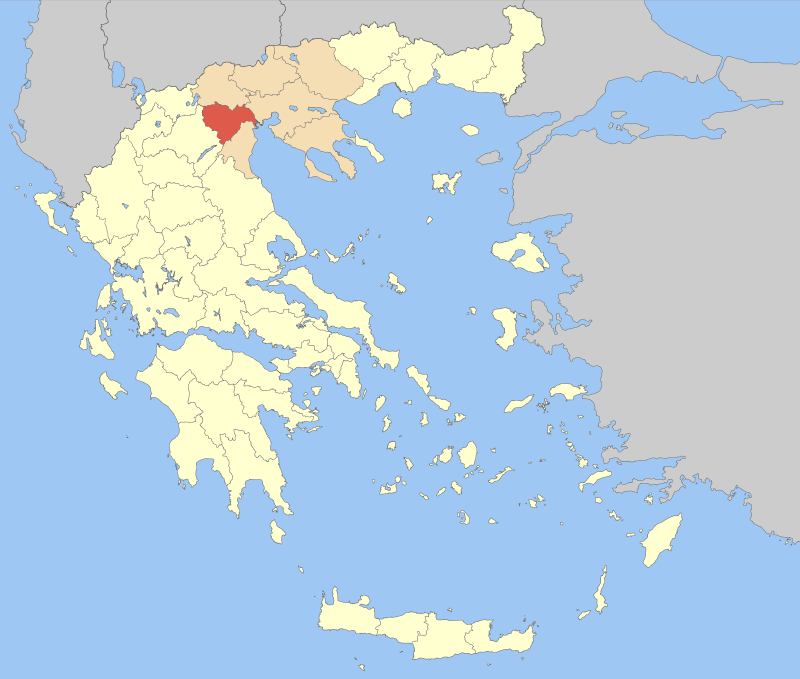
Basisdaten (April 2010)[1] Staat: Griechenland Verwaltungsregion: Zentralmakedonien Fläche: 1.701 km² Einwohner: 142.471 Bevölkerungsdichte: 83,76 Einwohner je km² Hauptstadt: Veria Stadtgemeinden (δήμοι): 12 Landgemeinden (κοινότητες): - ISO 3166-2 Code: GR-53 NUTS-3-Code: GR121 Kfz-Kennzeichen: HM (Imathia) Website: www.imathia.gr Imathia (griechisch Nomos Imathias Νομός Ημαθίας) war bis 2010 eine der sieben Präfekturen der griechischen Verwaltungsregion Zentralmakedonien. Hauptstadt der Präfektur war Veria. Mit der Verwaltungsreform von 2010 wurden die Kompetenzen der Präfektur an die Region Zentralmakedonien und die durch Zusammenlegung auf drei reduzierten Gemeinden übertragen, das Gebiet der Präfektur existiert als Regionalbezirk Imathia (gr. Periferiaki Enotita Imathias) weiter, der fünf Abgeordnete in den zentralmakedonischen Regionalrat entsendet, darüber hinaus aber keine politische Bedeutung hat.
Inhaltsverzeichnis
Geschichte
Das heilige Land von Imathia steht im Mittelpunkt der antiken makedonischen Kultur. Schon in der prähistorischen Zeit wurde dieses Land von Menschen bewohnt und erlebte während der Herrschaft durch Makedonien eine Blütezeit. In Imathia trifft man auf die Spuren einer Kultur, deren Präsenz von der Antike über Byzanz bis zur christlichen Epoche reicht. Der Ort Vergina war bis 410 v. Chr. die Hauptstadt des Königreiches Makedonien. Hier wurde auch der sechzehnstrahlige Stern von Vergina, ein Sonnensymbol, gefunden. Dieser war das Emblem der makedonischen Königsdynastie zur Zeit Philipps II. und Alexanders des Großen.
Wichtige Städte der Präfektur
- Veria, Hauptstadt und größte Stadt der Präfektur
- Naoussa
- Alexandria
- Makrochori
- Platy
- Vergina
Gemeinden (1997–2010)
Liste der Stadt- (Dimos) und Landgemeinden (Kinotita) der Präfektur Imathia Karte Nr. Gemeindename YPES- / LAU-Kode Verwaltungssitz Postleitzahl Telefon-
vorwahlEinwohner
2001Fläche in
km²Gemeinde-
bezirkeEinwohner
pro km²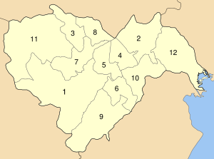
1 Veria Δήμος Βέροιας 1806 / 530100 Veria Βέροια 591 00 23310 47.411 358,521 11 132,24 2 Alexandria Δήμος Αλεξάνδρειας 1801 / 530200 Alexandria Αλεξάνδρεια 593 00 23330-2 19.283 140,089 6 137,65 3 Anthemia Δήμος Ανθεμίων 1802 / 530300 Kopanos Κοπανός 590 35 23330-2 8.147 74,538 6 109,30 4 Andigonides Δήμος Αντιγονιδών 1803 / 530400 Kavasila Καβάσιλα 591 00 23310-39 5.360 57,424 6 93,34 5 Apostolos Pavlos Δήμος Αποστόλου Παύλου 1804 / 530500 Makrochori Μακροχώρι 590 33 23310-41 8.579 63,477 5 135,15 6 Vergina Δήμος Βεργίνας 1805 / 530500 Vergina Βεργίνα 590 31 23310-92 2.478 68,847 4 35,99 7 Dovras Δήμος 1807 / 530700 Agios Georgios Άγιος Γεώργιος 591 00 23310-51 5.154 103,848 5 49,63 8 Irinoupoli Δήμος Ειρηνούπολης 1808 / 530800 Angelochori Αγγελοχώρι 590 34 23320-4 4.006 49,962 3 80,18 9 Makedonida Δήμος Μακεδονίδος 1809 / 530900 Rizomata Ριζώματα 591 00 23310-9 2.346 199,001 4 11,79 10 Meliki Δήμος Μελίκης 1810 / 531000 Meliki Μελίκη 590 31 23310-81 7.438 97,787 5 76,06 11 Naoussa Δήμος Νάουσας 1811 / 531100 Naoussa Νάουσα 592 00 23320-2 22.288 300,891 5 74,07 12 Platy Δήμος Πλατέος 1812 / 531200 Platy Πλατύ 590 32 23310-63 11.128 171,421 8 64,92 Summe bzw. Durchschnitt der Präfektur 12 Gemeinden, davon 12 Stadt- und 0 Landgemeinden 143.618 1.685,806 ' 85,19 Alle Angaben basieren auf öffentlich zugänglichen Informationen des Griechischen Innenministeriums (YPES).[2].
Die Landgemeinden sind hellblau unterlegt. Die Hauptstadt der Präfektur ist orange hinterlegt.
Die Fläche der Gemeinden wird nur mit der Landfläche berechnet: Wasserflächen werden nicht berücksichtigt.Einzelnachweise
- ↑ Die Einwohnerzahlen stammen aus einer Broschüre des griechischen Innenministeriums vom Mai 2010 anlässlich der Verwaltungsreform nach dem ‚Kallikratis-Gesetz‘: Elliniki Dimokratia, Ypourgeio Esoterikon, Apokendrosis ke Ilektronikis Diakyvernisis: "Programma Kallikratis," Systasi, syngrotisi Dimon, Periferion ke Apokendromenon Diikiseon gia ti Nea Architektoniki tis Aftodiikisis ke tis Apokendromenis Diikisis, Athen 2010.
- ↑ Lokale Selbstverwaltungen. Griechisches Innenministerium (ΥΠΟΥΡΓΕΙΟΥ ΕΣΩΤΕΡΙΚΩΝ, ΔΗΜΟΣΙΑΣ ΔΙΟΙΚΗΣΗΣ ΚΑΙ ΑΠΟΚΕΝΤΡΩΣΗΣ; ΥΠ.ΕΣ oder YPES)

Achaia | Argolis | Arkadien | Arta | Athen | Ätolien-Akarnanien | Böotien | Chalkidiki | Chania | Chios | Dodekanes | Drama | Elis | Euböa | Evrytania | Evros | Florina | Fokida | Fthiotida | Grevena | Imathia | Ioannina | Iraklio | Karditsa | Kastoria | Kavala | Kefallinia | Kilkis | Korfu | Korinthia | Kozani | Kykladen | Lakonien | Larisa | Lasithi | Lefkada | Lesbos | Magnisia | Messenien | Pella | Ostattika | Pieria | Piräus | Preveza | Rethymno | Rodopi | Samos | Serres | Thesprotia | Thessaloniki | Trikala | Westattika | Xanthi | Zakynthos
Wikimedia Foundation.
Schlagen Sie auch in anderen Wörterbüchern nach:
Imathia — Sp Imatijà Ap Ημαθία/Imathia L Š Graikijos nomas … Pasaulio vietovardžiai. Internetinė duomenų bazė
Imathia Prefecture — Infobox Pref GR name = Imathia name local = Νομός Ημαθίας flag reg = Flag of Greek Macedonia.svg periph = Central Macedonia capital = Veria population = 144,835 population as of = 2005 pop rank = 24th pop dens = 85.1 popdens rank = 11th area =… … Wikipedia
Naousa, Imathia — For a village on the island of Paros, see Naousa, Paros. Naousa Νάουσα … Wikipedia
Platy (Imathia) — Stadtgemeinde Platy (Imathias) (1994–2010) Δήμος Πλατέος (Πλατύ Ημαθίας) … Deutsch Wikipedia
Naoussa (Imathia) — Gemeinde Naoussa Δήμος Νάουσας (Νάουσα) … Deutsch Wikipedia
Trikala, Imathia — Trikala (Greek: Τρίκαλα) is a town in the eastern part of the Imathia prefecture between the boundaries of Thessaloniki and Pieria prefectures that are about 4 to 5 km away. Its 2001 population was 1,170 for the town. Trikala is also in the… … Wikipedia
List of settlements in the Imathia prefecture — List of settlements in the Imathia prefecture, Greece. Contents 1 A–B 2 C–D 3 E–F 4 G–I 5 … Wikipedia
Former toponyms of places in Imathia Prefecture — Many inhabited places in Imathia Prefecture of Greece have both Slavic and Greek forms. Some of the forms are identifiably of Greek origin, others of Slavic, yet others of Turkish or more obscure origins. Following the First World War and the… … Wikipedia
IWMN — Imathia Wireless Metropolitan Network or I.W.M.N. is a wireless non profit community created by people and citizens of Imathia, Greece. The scope of I.W.M.N is to create a wireless network all over Imathia. The network has nodes to Veria (Capital … Wikipedia
GR-53 — Präfektur Imathia Νομός Ημαθίας Basisdaten Staat: Griechenland … Deutsch Wikipedia
Imathia


18+
© Academic, 2000-2026
- Kontaktieren Sie uns: Unterstützung, Werbung
Wörterbücher Export, schritte mit PHP, Joomla, Drupal, WordPress, MODx.