- Birnie
-
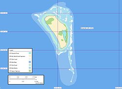
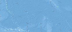
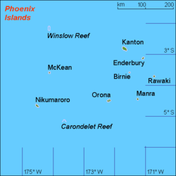
Birnie Karte von Birnie Gewässer Pazifischer Ozean Inselgruppe Phoenixinseln Geographische Lage 3° 35′ 6″ S, 171° 31′ 0″ W-3.585-171.51666666667Koordinaten: 3° 35′ 6″ S, 171° 31′ 0″ W Länge 1,2 km Breite 600 m Fläche <1 km² Einwohner (unbewohnt) Karte der Phoenixinseln, Birnie im Osten Birnie (englisch Birnie Island) ist eine kleine unbewohnte Koralleninsel der kiribatischen Phoenixinseln. Die lediglich 1,2 km lange und 0,6 km breite Insel, die kleinste der Phoenixinseln, liegt im zentralen Pazifischen Ozean etwa 90 km östlich von Rawaki, der Hauptinsel der Inselgruppe.
Die Insel ist ein gehobenes Atoll mit dem stark salzhaltigen Rest einer Lagune im Südwesten, die vom Meer vollständig getrennt ist. Wegen der unberührten Flora und Fauna ist Birnie ein wichtiges Naturschutzgebiet (Birnie Island Wildlife Sanctuary).
Birnie wurde 1823 vom Walfangschiff Sydney Packet unter Kapitän T. Emmett Master entdeckt und nach dem Schiffseigner, der Londoner Firma Alexander Birnie & Co. benannt.
Fotogalerie
Literatur
- Henry Evans Maude: Of islands and men : studies in Pacific history. Melbourne [u.a.] : Oxford Univ. Pr., 1968
- A. G. E. Jones: Ships employed in the South Seas trade. Vol. 1: 1775 - 1861; Canberra 1986 & Vol. 2: 1775 - 1859; Burwood, Vic. [1992]
Weblinks
Commons: Birnie – Sammlung von Bildern, Videos und Audiodateien- Informationen über das Naturreservat auf Birnie (englisch)
- Historische Karten, Bilder und Informationen (englisch)
Gilbertinseln: Abaiang | Abemama | Aranuka | Arorae | Beru | Butaritari | Kuria | Maiana | Makin | Marakei | Nikunau | Nonouti | Onotoa | Tabiteuea | Tamana | Tarawa
Line Islands: Caroline | Flint | Kiritimati | Malden | Starbuck | Tabuarean | Teraina | Vostok
Phoenixinseln: Birnie | Enderbury | Kanton | McKean | Manra | Nikumaroro | Orona | Rawaki
weitere Insel: Banaba
Wikimedia Foundation.
Schlagen Sie auch in anderen Wörterbüchern nach:
Birnie — Island (en) Carte de Birnie. Géographie Pays … Wikipédia en Français
Birnie — Birnie, Reich u. Hauptstadt desselben. im Innern NAfrikas, so v.w. Bornu … Pierer's Universal-Lexikon
Birnie — BIRNIE, a parish, in the county of Elgin, 3 miles (S.) from Elgin; containing 407 inhabitants. This place is said by some to have been the site of the first cathedral of the diocese of Moray; and it is probable that Simeon de Tonei, one of the … A Topographical dictionary of Scotland
birnie — birnie, birny variant of byrnie, Obs., cuirass … Useful english dictionary
Birnie — This name is of Scottish locational origin from a place thus called in the former county of Morays (now part of the Grampian region). Recorded in the 13th century as Brennath, the name is believed to derive from the Gaelic broanach meaning a damp … Surnames reference
Birnie — Admin ASC 2 Code Orig. name Birnie Country and Admin Code KI.03.BI KI … World countries Adminstrative division ASC I-II
Birnie Island — is a small, uninhabited coral island, 20 hectares in area, part of the Phoenix Island group, which forms a possession of the Republic of Kiribati. It is located about 100 km SE of Kanton Island and 90 km WNW of Rawaki Island, formerly known as… … Wikipedia
Birnie Loch — Geographische Lage Schottland Daten … Deutsch Wikipedia
Birnie Kirk — is a Church of Scotland church situated 4 km south of Elgin, in Moray, northeast Scotland. The church was built c. 1140 and became the first cathedral of the Bishop of Moray. It remained the cathedral church until 1184 when Bishop Simon de Tosny… … Wikipedia
Birnie Loch — Infobox lake lake name = Birnie Loch image lake = Birnie Loch dec 06 (400080952).jpg caption lake = image bathymetry = caption bathymetry = location = North East Fife, Scotland coords = Coord|56|18|4|N|3|9|25|W|region:GB… … Wikipedia