- Banbridge (District)
-
Banbridge District
Ceantar Dhroichead na Banna

Banbridge District 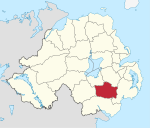
Geografie Traditionelle Grafschaft County Down Fläche 453 km² Verwaltungssitz Banbridge ISO 3166-2 GB-BNB Demografie Bevölkerung 47.000 (2008) Dichte 104 Ew./km² Konfessionen Protestanten: 66,0 %
Katholiken: 31,5 %Homepage
www.banbridgedc.gov.ukBanbridge (irisch Droichead na Banna) ist einer der 26 nordirischen Districts. Der District, dessen Gebiet in der traditionellen Grafschaft Down liegt, wurde 1973 eingerichtet. Bedeutende Orte im District sind die Stadt Banbridge, die auch Verwaltungssitz ist, sowie Gilford, Loughbrickland und Scarva.
Banbridge Council
Die Wahl zum Banbridge Council am 11. Mai 2011 hatte folgendes Ergebnis:[1]
Partei Ergebnis 2011 Veränderung zu 2006 Sitze Stimmen Sitze Stimmen Ulster Unionist Party (UUP) 7 33,8 % 2 1,4 % Democratic Unionist Party (DUP) 5 32,4 % -2 -6,0 % Social Democratic and Labour Party (SDLP) 2 13,2 % -1 -2,6 % Sinn Féin 2 11,4 % 1 5,1 % Alliance Party 1 4,9 % 0 0,4 % Traditional Unionist Voice 0 2,5 % 0 2,5 % Siehe auch
Einzelnachweise
- ↑ Wahlergebnis bei BBC News (Abgerufen am 26. Juli 2011)

Antrim | Ards | Armagh | Ballymena | Ballymoney | Banbridge | Belfast | Carrickfergus | Castlereagh | Coleraine | Cookstown | Craigavon | Derry | Down | Dungannon and South Tyrone | Fermanagh | Larne | Limavady | Lisburn | Magherafelt | Moyle | Newry and Mourne | Newtownabbey | North Down | Omagh | Strabane
Wikimedia Foundation.
Schlagen Sie auch in anderen Wörterbüchern nach:
Banbridge District — Admin ASC 2 Code Orig. name Banbridge District Country and Admin Code GB.NIR.R2 GB … World countries Adminstrative division ASC I-II
Banbridge District Council — Infobox Northern Ireland district district name = Banbridge District alt name = Comhairle Ceantair Dhroichead na Banna district area rank = 15th district area = 453 district HQ = Banbridge district iso = GB BNB district ons = 95Q protestant pc =… … Wikipedia
List of Areas of Special Scientific Interest in Banbridge District — NOTOC This is a list of the Areas of Special Scientific Interest (ASSIs) in the Banbridge District Council area in Northern Ireland, United Kingdom.In Northern Ireland the body responsible for designating ASSIs is the Environment and Heritage… … Wikipedia
Banbridge — District (pop., 2001: 41,392), Northern Ireland, established in 1973. The area includes the Legananny Hills, which reach an altitude of 1,745 ft (532 m) in eastern Banbridge district and slope southwestward to lowlands that are bisected by the… … Universalium
Banbridge — Infobox UK place official name= Banbridge Irish name= Droichead na Banna Ulster Scots name= Banbrig static static image caption= The Cut in Banbridge map type= Northern Ireland latitude= 54.343 longitude= 6.26 population= 14,744 (2001 Census)… … Wikipedia
District de Banbridge — 54° 21′ 04″ N 6° 16′ 01″ W / 54.351, 6.267 … Wikipédia en Français
District de Cookstown — Cookstown District Council (en) Comhairle Ceantair na Coirre Críochaí (ga) Districk Cooncil o Cookestoun ( … Wikipédia en Français
District de Carrickfergus — Carrickfergus Borough Council (en) Comhairle Baile Charraig Fheargais (ga) … Wikipédia en Français
District d'Omagh — 54° 36′ 00″ N 7° 17′ 53″ W / 54.600, 7.298 … Wikipédia en Français
District de Down — 54° 21′ 07″ N 5° 43′ 52″ W / 54.352, 5.731 … Wikipédia en Français
Banbridge (District)


18+
© Academic, 2000-2026
- Kontaktieren Sie uns: Unterstützung, Werbung
Wörterbücher Export, schritte mit PHP, Joomla, Drupal, WordPress, MODx.