Newry and Mourne

Newry and Mourne
Newry and Mourne District
Ceantar an Iúir agus Mhúrn
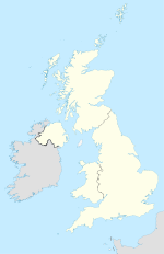
Newry and Mourne (Vereinigtes Königreich)
Newry and Mourne
Newry and Mourne
Lage in Nordirland
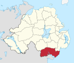
Geografie
Traditionelle Grafschaften County Armagh
County Down
Fläche 902 km²
Verwaltungssitz Newry
ISO 3166-2 GB-NYM
Demografie
Bevölkerung 97.300 (2008)
Dichte 108 Ew./km²
Konfessionen Protestanten: 18,5 %
Katholiken: 80,6 %
Homepage
www.newryandmourne.gov.uk

Newry and Mourne (irisch An tIúir agus Múrna) ist einer der 26 nordirischen Districts. Der District liegt auf dem Gebiet der traditionellen Grafschaften Armagh und Down und wurde 1973 eingerichtet. Bedeutende Orte sind die Stadt Newry, die auch Verwaltungssitz ist, sowie Crossmaglen, Bessbrook, Warrenpoint, Rostrevor, Hilltown, Annalong and Kilkeel.

Newry and Mourne Council

Die Wahl zum Newry and Mourne Council am 11. Mai 2011 hatte folgendes Ergebnis:[1]

Partei Ergebnis 2011 Veränderung zu 2006
Sitze Stimmen Sitze Stimmen
  Sinn Féin 14 45,2 % 1 3,1 %
  Social Democratic and Labour Party (SDLP) 9 28,9 % 0 -0,6 %
  Ulster Unionist Party (UUP) 3 10,3 % 0 -0,5 %
  United Kingdom Independence Party 1 4,8 % 1 4,8 %
  Democratic Unionist Party (DUP) 1 3,0 % -1 -3,7 %
  Green Party 0 1,0 % -1 -1,1 %
  Traditional Unionist Voice 0 1,0 % 0 1,0 %
  Unabhängige 2 5,6 % 0 -3,2 %

Siehe auch

Einzelnachweise

  1. Wahlergebnis bei BBC News (Abgerufen am 26. Juli 2011)

Wikimedia Foundation.

Игры ⚽ Нужен реферат?

Schlagen Sie auch in anderen Wörterbüchern nach:

  • Newry and Mourne —   [ njʊərɪ ənd mɔːn], Distrikt im Süden Nordirlands, 909 km2, 84 500 Einwohner, Verwaltungssitz ist Newry (19 000 Einwohner) …   Universal-Lexikon

  • Newry and Mourne — District (pop., 2001: 87,058), southeastern Northern Ireland. Bordered by the Irish Sea and the republic of Ireland, it is divided in two by the Newry Canal, the first major canal in the British Isles, built 1730–41. Limestone and granite are… …   Universalium

  • Newry and Mourne — Sp Niūris ir Mòrnas Ap Newry and Mourne L Š. Airijos apyg., Jungtinė Karalystė …   Pasaulio vietovardžiai. Internetinė duomenų bazė

  • Newry and Mourne — Sp Niūris ir Mòrnas Ap Newry and Mourne L Š. Airijos apyg., D. Britanija …   Pasaulio vietovardžiai. Internetinė duomenų bazė

  • Newry and Mourne District Council — Coordinates: 54°10′34″N 6°15′22″W / 54.176°N 6.256°W / 54.176; 6.256 …   Wikipedia

  • Newry and Mourne District — Admin ASC 2 Code Orig. name Newry and Mourne District Country and Admin Code GB.NIR.S9 GB …   World countries Adminstrative division ASC I-II

  • Newry and Mourne — ► Distrito de Gran Bretaña, en el S de Irlanda del Norte; 910 km2 y 87 800 h. C. principal: Newry (20 279 h) …   Enciclopedia Universal

  • Ville et district de Newry and Mourne — Newry and Mourne City and Borough Council (en) Comhairle an Iúir agus Mhúrn (ga) …   Wikipédia en Français

  • Newry and Mourne — geographical name district S Northern Ireland area 345 square miles (894 square kilometers), population 82,288 …   New Collegiate Dictionary

  • Newry and Armagh (UK Parliament constituency) — For other constituencies of the same name, see Newry and Armagh (disambiguation). Newry and Armagh County constituency Newry and Armagh shown within Northern Ireland Created: 1983 MP …   Wikipedia

Share the article and excerpts

Direct link
Do a right-click on the link above
and select “Copy Link”