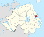
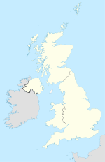
- Carrickfergus (Borough)
-
Carrickfergus Borough
Buirg Charraig Fheargais
Geografie Traditionelle Grafschaft County Antrim Fläche 82 km² Verwaltungssitz Carrickfergus ISO 3166-2 GB-CKF Demografie Bevölkerung 40.000 (2008) Dichte 489 Ew./km² Konfessionen Protestanten: 85,1 %
Katholiken: 8,7 %Homepage
http://www.carrickfergus.orgCarrickfergus (irisch Carraig Fhearghais) ist einer der 26 nordirischen Districts. Der District, dessen Gebiet in der traditionellen Grafschaft Antrim liegt, wurde 1973 eingerichtet und besitzt den Status eines Borough. Bedeutende Orte im Borough sind die Stadt Carrickfergus, die auch Verwaltungssitz ist, sowie Greenisland und Whitehead. Der District Carrickfergus hat den höchsten protestantischen Bevölkerungsanteil aller nordirischen Districts.
Carrickfergus Council
Die Wahl zum Carrickfergus Council am 11. Mai 2011 hatte folgendes Ergebnis:[1]
Partei Ergebnis 2011 Veränderung zu 2006 Sitze Stimmen Sitze Stimmen Democratic Unionist Party (DUP) 8 43,2 % 1 -1,8 % Ulster Unionist Party (UUP) 4 15,9 % 0 -3,1 % Alliance Party 3 25,1 % 1 5,7 % Green Party 0 2,4 % 0 2,4 % Unabhängige 2 13,5 % 0 -3,2 % Siehe auch
Einzelnachweise
- ↑ Wahlergebnis bei BBC News (Abgerufen am 26. Juli 2011)
Antrim | Ards | Armagh | Ballymena | Ballymoney | Banbridge | Belfast | Carrickfergus | Castlereagh | Coleraine | Cookstown | Craigavon | Derry | Down | Dungannon and South Tyrone | Fermanagh | Larne | Limavady | Lisburn | Magherafelt | Moyle | Newry and Mourne | Newtownabbey | North Down | Omagh | Strabane
Wikimedia Foundation.
Schlagen Sie auch in anderen Wörterbüchern nach:
Carrickfergus Borough Council — NI district district name = Carrickfergus Borough alt name = Comhairle Baile Charraig Fheargais district area rank = 25th district area = 82 district HQ = Carrickfergus district iso = GB CKF district ons = 95V protestant pc = 85.1% catholic pc =… … Wikipedia
Carrickfergus — Carrickfergus … Wikipédia en Français
Carrickfergus — Infobox UK place official name= Carrickfergus irish name= Carraig Fhearghais map type= Northern Ireland latitude= 54.716 longitude= 5.803 population= 27,201 (2001 Census) irish grid reference= unitary northern ireland= Carrickfergus Borough… … Wikipedia
Carrickfergus railway station — Infobox NI station name = Carrickfergus locale = Victoria Street, Carrickfergus borough = Carrickfergus Borough Council years = 1862 2001 events = Original station opened Station refurbished platforms = 3 usage0405 = Carrickfergus railway station … Wikipedia
Carrickfergus and Belfast (constituency) — Carrickfergus and Belfast was a constituency in Ireland, that returned a single Member of Parliament to sit in the House of Commons of the Commonwealth of England, Scotland and Ireland. It was represented in the three Protectorate Parliaments,… … Wikipedia
Carrickfergus (Parliament of Ireland constituency) — Parliament of Ireland former constituency infobox Name = Carrickfergus Type = Borough Year = 1326 Post Union = Carrickfergus (UK Parliament constituency)Carrickfergus was a constituency represented in the Irish House of Commons from 1326 to… … Wikipedia
Carrickfergus (UK Parliament constituency) — UK former constituency infobox Name = Carrickfergus Type = Borough Year = 1801 Abolition = 1885Carrickfergus is a former United Kingdom Parliament constituency, in Ireland, returning one MP.BoundariesThis constituency was the Parliamentary… … Wikipedia
Larne Borough Council — NI district district name = Larne Borough alt name = Comhairle Baile Latharna district area rank = 21st district area = 336 district HQ = Larne district iso = GB LRN district ons = 95F protestant pc = 71.7% catholic pc = 25.2% web address =… … Wikipedia
District de Carrickfergus — Carrickfergus Borough Council (en) Comhairle Baile Charraig Fheargais (ga) … Wikipédia en Français
Ballymena Borough Council — NI district district name = Ballymena Borough alt name = Comhairle Baile an Bhaile Meánaigh district area rank = 8th district area = 632 district HQ = Ballymena district iso = GB BLA district ons = 95G protestant pc = 76.3% catholic pc = 21.0%… … Wikipedia

