- Derry (District)
-
Derry District
Ceantar Dhoire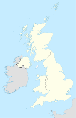

Derry (District) 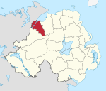
Geografie Traditionelle Grafschaft County Londonderry Fläche 378 km² Verwaltungssitz Derry bzw. Londonderry ISO 3166-2 GB-DRY Demografie Bevölkerung 109.100 (2008) Dichte 282 Ew./km² Konfessionen Protestanten 23,2 %
Katholiken 75,4 %Verwaltung Wahlbezirke Cityside, Northland, Rural, Shantallow und Waterside Homepage
www.derrycity.gov.ukDerry (irisch Doire) ist einer der 26 nordirischen Districts und liegt in der traditionellen Grafschaft Londonderry. Der Distrikt wurde 1973 gebildet aus dem County Borough Londonderry, das die eigentliche Stadt Derry bzw. Londonderry umfasste und dem Rural District Londonderry, zu dem das ländlich geprägte Umland gehörte. Neben der Stadt Derry liegen heute unter anderem die Orte Culmore, Newbuildings, Strathfoyle und Eglinton im District.
Der 1973 gebildete Distrikt hieß zunächst Londonderry, wurde 1984 jedoch amtlich in Derry umbenannt. Da die eigentliche Stadt Derry den Status einer City besitzt, trägt die Verwaltungsbehörde des gesamten Distrikts die Bezeichnung Derry City Council.
Derry City Council
Die Wahl zum Derry City Council am 11. Mai 2011 hatte folgendes Ergebnis:[1]
Partei Ergebnis 2011 Veränderung zu 2006 Sitze Stimmen Sitze Stimmen Social Democratic and Labour Party (SDLP) 14 38,2 % 0 -2,9 % Sinn Féin 10 33,9 % 0 1,0 % Democratic Unionist Party (DUP) 5 14,7 % 0 -1,5 % Ulster Unionist Party (UUP) 1 4,0 % 0 -0,5 % Alliance Party 0 0,9 % 0 0,9 % Sonstige 0 5,8 % 0 5,8 % Siehe auch
Einzelnachweise
- ↑ Wahlergebnis bei BBC News (Abgerufen am 26. Juli 2011)

Antrim | Ards | Armagh | Ballymena | Ballymoney | Banbridge | Belfast | Carrickfergus | Castlereagh | Coleraine | Cookstown | Craigavon | Derry | Down | Dungannon and South Tyrone | Fermanagh | Larne | Limavady | Lisburn | Magherafelt | Moyle | Newry and Mourne | Newtownabbey | North Down | Omagh | Strabane
Wikimedia Foundation.
Schlagen Sie auch in anderen Wörterbüchern nach:
Derry (Begriffsklärung) — Derry steht für Derry, eine Stadt in Nordirland Derry (District), einen nordirischen District County Londonderry, eine Grafschaft in Nordirland Derry (Fluss), ein Fluss im County Wicklow Derry (New Hampshire), eine Stadt in den Vereinigten… … Deutsch Wikipedia
Derry GAA club football competitions — The following are club Gaelic football competitions run by the Derry County Board. Contents 1 Adult 1.1 Championships 1.1.1 Derry Senior Football Championship 1.1.2 … Wikipedia
Derry — geographical name 1. city SE New Hampshire SE of Manchester population 34,021 2. (or Londonderry) district NW Northern Ireland, established 1974 area 148 square miles (383 square kilometers), population 94,918 3. (or Londonderry) port NW Derry… … New Collegiate Dictionary
Derry Township School District — Address 30 East Granada Avenue, P.O. Box 898 Hershey, Pennsylvania, Dauphin … Wikipedia
Derry Area School District — Address 982 North Chestnut Street Derry, Pennsylvania, Westmoreland … Wikipedia
Derry City Council — Derry City Coat of Arms and Logo Geography … Wikipedia
Derry — Wappen Karte … Deutsch Wikipedia
Derry, New Hampshire — Town Broadway c. 1905 … Wikipedia
Derry Township Police (Pennsylvania) — Derry Township Police Common name Derry Police Abbreviation DTPD … Wikipedia
Derry Journal Newspapers — (formerly Local Press Ltd) is a holding company of Johnston Press that operates several local newspapers in Northern Ireland and the Republic of Ireland. Its key titles include the second oldest newspaper still in existence in Ireland, the Derry… … Wikipedia
Derry (District)


18+
© Academic, 2000-2025
- Kontaktieren Sie uns: Unterstützung, Werbung
Wörterbücher Export, schritte mit PHP, Joomla, Drupal, WordPress, MODx.