- Cookstown (District)
-
Cookstown District
Ceantar na Coirre Críochaí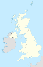

Cookstown District 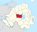
Geografie Traditionelle Grafschaft County Tyrone und County Londonderry Fläche 622 km² Verwaltungssitz Cookstown ISO 3166-2 GB-CKT Demografie Bevölkerung 35.900 (2008) Dichte 58 Ew./km² Konfessionen Protestanten 34,8 %
Katholiken 64,1 %Homepage
www.cookstown.gov.ukCookstown (irisch An Chorr Chríochach) ist einer der 26 nordirischen Districts. Der District, dessen Gebiet in den traditionellen Grafschaften Tyrone und Londonderry liegt, wurde 1973 eingerichtet. Der Verwaltungssitz ist die Stadt Cookstown. Weitere bedeutende Orte sind Pomeroy, Moneymore, Coagh und Stewartstown. Der District liegt am Ostufer von Lough Neagh.
Cookstown Council
Die Wahl zum Cookstown Council am 11. Mai 2011 hatte folgendes Ergebnis:[1]
Partei Ergebnis 2011 Veränderung zu 2006 Sitze Stimmen Sitze Stimmen Sinn Féin 6 39,1 % 1 5,6 % Social Democratic and Labour Party (SDLP) 4 18,0 % -1 0,7 % Democratic Unionist Party (DUP) 3 18,1 % 0 -4,4 % Ulster Unionist Party (UUP) 3 16,9 % 0 -2,6 % Traditional Unionist Voice 0 7,4 % 0 7,4 % Siehe auch
Einzelnachweise
- ↑ Wahlergebnis bei BBC News (Abgerufen am 26. Juli 2011)

Antrim | Ards | Armagh | Ballymena | Ballymoney | Banbridge | Belfast | Carrickfergus | Castlereagh | Coleraine | Cookstown | Craigavon | Derry | Down | Dungannon and South Tyrone | Fermanagh | Larne | Limavady | Lisburn | Magherafelt | Moyle | Newry and Mourne | Newtownabbey | North Down | Omagh | Strabane
Wikimedia Foundation.
Schlagen Sie auch in anderen Wörterbüchern nach:
Cookstown District — Admin ASC 2 Code Orig. name Cookstown District Country and Admin Code GB.NIR.R7 GB … World countries Adminstrative division ASC I-II
Cookstown District Council — Coordinates: 54°38′46″N 6°44′42″W / 54.646°N 6.745°W / 54.646; 6.745 … Wikipedia
District de Cookstown — Cookstown District Council (en) Comhairle Ceantair na Coirre Críochaí (ga) Districk Cooncil o Cookestoun ( … Wikipédia en Français
Cookstown — District (pop., 2001: 32,581), Northern Ireland. In an agricultural region, it has extensive dairy farming and cattle, poultry, and sheep raising. The town of Cookstown (pop., 1991: 9,842) is the administrative centre; it was originally a 17th… … Universalium
Cookstown — For other towns of this name, see Cookstown (disambiguation). Coordinates: 54°38′49″N 6°44′42″W / 54.647°N 6.745°W / 54.647; 6.7 … Wikipedia
District de Carrickfergus — Carrickfergus Borough Council (en) Comhairle Baile Charraig Fheargais (ga) … Wikipédia en Français
District de Castlereagh — 54°35′N 5°52′W / 54.583, 5.867 … Wikipédia en Français
District d'Antrim — 54° 43′ 37″ N 6° 12′ 36″ W / 54.727, 6.210 … Wikipédia en Français
District d'Ards — 54° 31′ 16″ N 5° 44′ 49″ W / 54.521, 5.747 … Wikipédia en Français
District d'Omagh — 54° 36′ 00″ N 7° 17′ 53″ W / 54.600, 7.298 … Wikipédia en Français
Cookstown (District)


18+
© Academic, 2000-2026
- Kontaktieren Sie uns: Unterstützung, Werbung
Wörterbücher Export, schritte mit PHP, Joomla, Drupal, WordPress, MODx.