Limavady (Borough)

Limavady (Borough)
Limavady Borough
Buirg Léim an Mhadaidh
Limavady Borough (Vereinigtes Königreich)
Limavady Borough
Limavady Borough
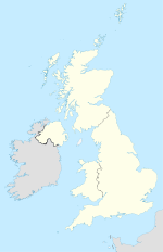
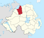
Lage in Nordirland
Geografie
Traditionelle Grafschaft County Londonderry
Fläche 586 km²
Verwaltungssitz Limavady
ISO 3166-2 GB-LMV
Demografie
Bevölkerung 34.100 (2008)
Dichte 58 Ew./km²
Konfessionen Protestanten: 41,6 %
Katholiken: 56,6 %
Homepage
www.limavady.gov.uk

Limavady (irisch Léim an Mhadaidh) ist einer der 26 nordirischen Districts. Der District, dessen Gebiet in der traditionellen Grafschaft Londonderry liegt, wurde 1973 eingerichtet und besitzt den Status eines Borough. Bedeutende Orte im Borough sind die Stadt Limavady, die auch Verwaltungssitz ist, sowie Dungiven und Ballykelly.

Limavady Council

Die Wahl zum Limavady Council am 11. Mai 2011 hatte folgendes Ergebnis:[1]

Partei Ergebnis 2011 Veränderung zu 2006
Sitze Stimmen Sitze Stimmen
  Sinn Féin 6 38,0 % 0 6,9 %
  Democratic Unionist Party (DUP) 3 26,2 % 0 2,5 %
  Social Democratic and Labour Party (SDLP) 3 14,5 % 0 -9,2 %
  Ulster Unionist Party (UUP) 2 9,6 % 0 -1,8 %
  Traditional Unionist Voice 1 5,5 % 1 5,5 %
  Alliance Party 0 2,0 % 0 2,0 %
  Sonstige 0 0,0 % -1 -10,0 %

Siehe auch

Einzelnachweise

  1. Wahlergebnis bei BBC News (Abgerufen am 26. Juli 2011)

Wikimedia Foundation.

Игры ⚽ Нужно сделать НИР?

Schlagen Sie auch in anderen Wörterbüchern nach:

  • Limavady Borough Council — NI district district name = Limavady Borough alt name = Comhairle Baile Léim an Mhadaidh district area rank = 10th district area = 586 district HQ = Limavady district iso = GB LMV district ons = 95B protestant pc = 41.6% catholic pc = 56.6% web… …   Wikipedia

  • Limavady — (lɪməˈvædi; irisch: Léim an Mhadaidh; dt.: „Sprung des Hundes“) ist eine größere Marktstadt im County Londonderry in Nordirland sowie Verwaltungssitz des gleichnamigen Districts. Inhaltsverzeichnis 1 Der Ort 2 Musikkultur …   Deutsch Wikipedia

  • Limavady — Coordinates: 55°03′11″N 6°56′46″W / 55.053°N 6.946°W / 55.053; 6.946 …   Wikipedia

  • Limavady Grammar School — Infobox UK school name = Limavady Grammar School size = latitude = longitude = dms = motto = Vita, Veritas, Victoria Life, Truth Victory motto pl = established = 1957 (present site) approx = closed = c approx = type = grammar school religion =… …   Wikipedia

  • District de Limavady — 55° 03′ 04″ N 6° 57′ 04″ W / 55.051, 6.951 …   Wikipédia en Français

  • Ballymoney Borough Council — NI district district name = Ballymoney Borough alt name = Comhairle Baile Bhaile Monaidh district area rank = 17th district area = 418 district HQ = Ballymoney district iso = GB BLY district ons = 95D protestant pc = 66.2% catholic pc = 31.9% web …   Wikipedia

  • Coleraine Borough Council — Coordinates: 55°07′55″N 6°40′05″W / 55.132°N 6.668°W / 55.132; 6.668 …   Wikipedia

  • Ards (borough) — Coordinates: 54°31′16″N 5°44′49″W / 54.521°N 5.747°W / 54.521; 5.747 …   Wikipedia

  • Ballymoney (borough) — Ballymoney Borough Geography Area Total Ranked 17th of 26 418 km² …   Wikipedia

  • Newtownabbey Borough Council — Newtownabbey Borough Geography Area Total Ranked 22nd of 26 151 km² …   Wikipedia

Share the article and excerpts

Direct link
Do a right-click on the link above
and select “Copy Link”