- Newtownabbey (Borough)
-
Newtownabbey Borough
Buirg Bhaile na Mainistreach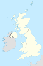

Newtownabbey Borough 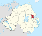
Geografie Traditionelle Grafschaft County Antrim Fläche 151 km² Verwaltungssitz Newtownabbey ISO 3166-2 GB-NTA Demografie Bevölkerung 82.700 (2008) Dichte 549 Ew./km² Konfessionen Protestanten 76,2 %
Katholiken 19,4 %Homepage
www.newtownabbey.gov.ukNewtownabbey (irisch Baile na Mainistreach) ist einer der 26 nordirischen Districts. Der District, dessen Gebiet in der traditionellen Grafschaft Antrim liegt, wurde 1973 eingerichtet und besitzt den Status eines Borough. Er umfasst die nördlichen Vororte von Belfast. Bedeutende Orte sind der Verwaltungssitz Newtownabbey, Ballyclare, Glengormley und Jordanstown.
Newtownabbey ist Partnerbezirk von Gilbert im US-Bundesstaat Arizona.
Newtownabbey Council
Die Wahl zum Newtownabbey Council am 11. Mai 2011 hatte folgendes Ergebnis:[1]
Partei Ergebnis 2011 Veränderung zu 2006 Sitze Stimmen Sitze Stimmen Democratic Unionist Party (DUP) 12 43,5 % 0 -0,4 % Ulster Unionist Party (UUP) 5 19,7 % -1 -3,6 % Alliance Party 5 16,4 % 3 8,4 % Sinn Féin 2 9,6 % 1 3,7 % Social Democratic and Labour Party (SDLP) 1 5,3 % 0 -0,8 % Sonstige 0 2,2 % -1 -7,6 % Siehe auch
Einzelnachweise
- ↑ Wahlergebnis bei BBC News (Abgerufen am 26. Juli 2011)

Antrim | Ards | Armagh | Ballymena | Ballymoney | Banbridge | Belfast | Carrickfergus | Castlereagh | Coleraine | Cookstown | Craigavon | Derry | Down | Dungannon and South Tyrone | Fermanagh | Larne | Limavady | Lisburn | Magherafelt | Moyle | Newry and Mourne | Newtownabbey | North Down | Omagh | Strabane
Wikimedia Foundation.
Schlagen Sie auch in anderen Wörterbüchern nach:
Newtownabbey Borough Council — Newtownabbey Borough Geography Area Total Ranked 22nd of 26 151 km² … Wikipedia
Newtownabbey — irisch Baile Nua na Mainistreach Koordinaten … Deutsch Wikipedia
Newtownabbey — Coordinates: 54°39′25″N 5°54′25″W / 54.657°N 5.907°W / 54.657; 5.907 … Wikipedia
Newtownabbey Ratepayers' Association — The Newtownabbey Ratepayers Association was a minor political party operating in Newtownabbey, Northern Ireland It has contest elections for Newtownabbey Borough Council from 1997 to 2005 and registered as a political party with the Electoral… … Wikipedia
Newtownabbey Ratepayers Association — The Newtownabbey Ratepayers Association was a minor political party operating in Newtownabbey, Northern IrelandIt has contest elections for Newtownabbey Borough Council from 1997 to 2005 and registered as a political party with the Electoral… … Wikipedia
Newtownabbey Labour Party — The Newtownabbey Labour Party is a minor political party based in Newtownabbey, Northern Ireland. The party originated as the Newtownabbey branch of the Northern Ireland Labour Party. It left its parent organisation in the 1970s.[1] Early members … Wikipedia
Newtownabbey (Northern Ireland Parliament constituency) — Coordinates: 54°41′06″N 5°57′58″W / 54.685°N 5.966°W / 54.685; 5.966 … Wikipedia
Antrim Borough Council — NI district district name = Antrim Borough alt name = Comhairle Baile Aontroma district area rank = 11th district area = 577 district HQ = Antrim district iso = GB ANT district ons = 95T protestant pc = 56.7% catholic pc = 38.6% web address =… … Wikipedia
District de Newtownabbey — 54°39′25″N 5°54′25″O / 54.65694, 5.90694 … Wikipédia en Français
Antrim and Newtownabbey District Council — Antrim and Newtonabbey District Council is a proposed Northern Irish local government district. Under the latest decision by the Review of Public Administration the district would be created by merging Antrim Borough Council and Newtownabbey… … Wikipedia
Newtownabbey (Borough)


18+
© Academic, 2000-2026
- Kontaktieren Sie uns: Unterstützung, Werbung
Wörterbücher Export, schritte mit PHP, Joomla, Drupal, WordPress, MODx.