- Omagh (District)
-
Omagh District
Ceantar na hÓmaí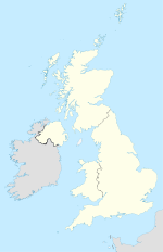

Omagh District 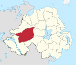
Geografie Traditionelle Grafschaft County Tyrone Fläche 1.130 km² Verwaltungssitz Omagh ISO 3166-2 GB-OMH Demografie Bevölkerung 52.100 (2008) Dichte 46 Ew./km² Konfessionen Protestanten 29,7 %
Katholiken 69,1 %Homepage
www.omagh.gov.ukOmagh (irisch An Ómaigh) ist einer der 26 nordirischen Districts. Der District, dessen Gebiet in der traditionellen Grafschaft Tyrone liegt, wurde 1973 eingerichtet. Bedeutende Orte sind der Verwaltungssitz Omagh sowie Drumquin, Dromore, Trillick, Fintona, Beragh, Carrickmore und Sixmilecross.
Omagh Council
Die Wahl zum Omagh Council am 11. Mai 2011 hatte folgendes Ergebnis:[1]
Partei Ergebnis 2011 Veränderung zu 2006 Sitze Stimmen Sitze Stimmen Sinn Féin 10 46,9 % 0 2,3 % Democratic Unionist Party (DUP) 3 16,4 % 0 -0,3 % Ulster Unionist Party (UUP) 3 14,3 % 0 1,3 % Social Democratic and Labour Party (SDLP) 3 13,3 % 0 -6,0 % Alliance Party 0 1,5 % 0 1,5 % Unabhängige 2 7,6 % 0 1,4 % Siehe auch
Einzelnachweise
- ↑ Wahlergebnis bei BBC News (Abgerufen am 26. Juli 2011)

Antrim | Ards | Armagh | Ballymena | Ballymoney | Banbridge | Belfast | Carrickfergus | Castlereagh | Coleraine | Cookstown | Craigavon | Derry | Down | Dungannon and South Tyrone | Fermanagh | Larne | Limavady | Lisburn | Magherafelt | Moyle | Newry and Mourne | Newtownabbey | North Down | Omagh | Strabane
Wikimedia Foundation.
Schlagen Sie auch in anderen Wörterbüchern nach:
Omagh District — Admin ASC 2 Code Orig. name Omagh District Country and Admin Code GB.NIR.T3 GB … World countries Adminstrative division ASC I-II
Omagh District Council — Coordinates: 54°36′00″N 7°17′53″W / 54.600°N 7.298°W / 54.600; 7.298 … Wikipedia
Fermanagh and Omagh District Council — Fermanagh and Omagh District is a proposed Northern Irish local government district. Under the latest decision by the Review of Public Administration the district would be created by merging Fermanagh District Council and Omagh District Council.… … Wikipedia
Omagh — District (pop., 2001: 47,735) and town (pop., 1991: 18,000), Northern Ireland. Formerly in County Tyrone, the district was established in 1973. The area was ruled by the ancient O Neill family (5th–16th centuries), passing to English rule after… … Universalium
Omagh — This article is about the town of Omagh. For the film of same name, see Omagh (film). Coordinates: 54°35′N 7°17′W / 54.59°N 7.29°W / 54 … Wikipedia
Omagh bombing — Coordinates: 54°36′0″N 7°17′52″W / 54.6°N 7.29778°W / 54.6; 7.29778 … Wikipedia
District d'Omagh — 54° 36′ 00″ N 7° 17′ 53″ W / 54.600, 7.298 … Wikipédia en Français
Omagh — geographical name 1. district W Northern Ireland, established 1974 area 436 square miles (1134 square kilometers), population 45,343 2. town W Northern Ireland in central Omagh district population 17,280 … New Collegiate Dictionary
Omagh — /oʊˈma/ (say oh mah) noun 1. a town in Northern Ireland, in Omagh district, in County Tyrone. 2. a unitary district in western Northern Ireland in County Tyrone. 1130 km2 …
Omagh — Omagh … Wikipédia en Français
Omagh (District)


18+
© Academic, 2000-2026
- Kontaktieren Sie uns: Unterstützung, Werbung
Wörterbücher Export, schritte mit PHP, Joomla, Drupal, WordPress, MODx.