- Ballymoney (Borough)
-
Ballymoney Borough
Buirg Bhaile Monaidh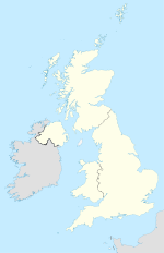

Ballymoney Borough 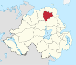
Geografie Traditionelle Grafschaft County Antrim Fläche 418 km² Verwaltungssitz Ballymoney ISO 3166-2 GB-BLY Demografie Bevölkerung 30.100 (2008) Dichte 72 Ew./km² Konfessionen Protestanten: 66,2 %
Katholiken: 31,9 %Homepage
www.ballymoney.gov.ukBallymoney (irisch Baile Monaidh) ist einer der 26 nordirischen Districts. Der District, dessen Gebiet in der traditionellen Grafschaft Antrim liegt, wurde 1973 eingerichtet und besitzt den Status eines Borough. Bedeutende Orte im Borough sind die Stadt Ballymoney, die auch Verwaltungssitz ist, sowie Dervock, Dunloy, Cloughmills and Rasharkin.
Ballymoney Council
Die Wahl zum Ballymoney Council am 11. Mai 2011 hatte folgendes Ergebnis:[1]
Partei Ergebnis 2011 Veränderung zu 2006 Sitze Stimmen Sitze Stimmen Democratic Unionist Party (DUP) 8 45,3 % 0 -3,6 % Sinn Féin 3 20,5 % 0 0,5 % Ulster Unionist Party (UUP) 2 13,7 % 0 -1,4 % Social Democratic and Labour Party (SDLP) 1 9,9 % -1 -2,4 % Traditional Unionist Voice 1 7,6 % 1 7,6 % Unabhängige 1 3,0 % 0 -0,8 % Siehe auch
Einzelnachweise
- ↑ Wahlergebnis bei BBC News (Abgerufen am 26. Juli 2011)

Antrim | Ards | Armagh | Ballymena | Ballymoney | Banbridge | Belfast | Carrickfergus | Castlereagh | Coleraine | Cookstown | Craigavon | Derry | Down | Dungannon and South Tyrone | Fermanagh | Larne | Limavady | Lisburn | Magherafelt | Moyle | Newry and Mourne | Newtownabbey | North Down | Omagh | Strabane


Wikimedia Foundation.