- Tactical Air Navigation
-
 International gültiges Symbol für TACAN auf einer Luftfahrtkarte
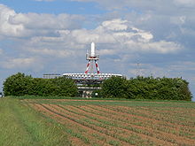
Tactical Air Navigation (TACAN, englisch für taktische Flugnavigation) bezeichnet ein militärisches Flugnavigationsverfahren, ähnlich dem zivil genutzten VOR/DME. Kombinationen aus zivilem VOR-DME und militärischem TACAN nennt man VORTAC.
TACAN-Funkfeuer arbeiten im UHF-Bereich (962-1213 MHz unterteilt in 126X und 126Y-Kanäle). Die Richtungsinformation wird beim TACAN stets auf magnetisch Nord bezogen (vergl. VOR). Das entsprechende Anzeigeinstrument zeigt immer den rechtsdrehenden Winkel von Nord bis zur Verbindungslinie Luftfahrzeug - Bodenstation.
Während die Richtungsinformation beliebig vielen Luftfahrzeugen gleichzeitig zu Verfügung steht, können für die Entfernungsmessung nur max. 100 Luftfahrzeuge gleichzeitig bedient werden, wobei immer die 100 stärksten Signale Vorrang haben. Die vom TACAN gelieferten Entfernungen sind allerdings grundsätzlich Schrägentfernungen, d.h. die direkte Entfernung zwischen Luftfahrzeug und Bodenstation. Die Ermittlung der exakten Entfernung ist nur möglich, wenn die Höhe über Grund oder der Erhebungswinkel bekannt ist. Das TACAN arbeitet bei quasioptischer Sicht bis zu einer Entfernung von 390 nautischen Meilen.
Anders als beim VOR kann sich eine TACAN-Station auch an Bord eines anderen militärischen Luftfahrzeuges befinden und wird z.B. bei Tankanflügen benutzt.
Die Anpeilung anderer Luftfahrzeuge ist aber ungenauer als zu einer Bodenstation da von den meisten Flugzeugen nur der 15Hz Sinus gesendet werden kann welcher somit eine Genauigkeit/ Fehler von ca 3° bis 5° nach sich zieht. Bei einer TACAN Bodenstation wird der 15Hz Sinus zusätzlich durch 135Hz Amplitudenmodulation moduliert, somit sind die 15Hz die Grobinformation und die 135 Hz die Feininformation der Richtung zur Station bezogen auf Magnetisch Nord. Zusätzlich wird anders als beim VOR der Hauptbezugsimpuls (MRB) nur ausgesendet wenn das Drehfunkfeuer Richtung Osten zeigt, alle 40 Grad wird ein Nebenbezugsimpuls (ARB) ausgesendet. Der MRB ist für die Anlage insoweit wichtig da dieser den Startpunkt der Winkelmessung zum nächsten Positiven Nulldurchgang der 15Hz Schwingung markiert. Somit ergibt sich Beispielsweise bei einem MRB Impuls bei 180° zum nächsten positiven Nulldurchgang der Sinusschwingung 15Hz (360°) ein Winkel von 180° also liegt die Station Richtung Süden. Bei MRB 90°(neg.)= Winkel 90° zum nächsten pos. Nulldurchgang= Station Richtung Osten Bei MRB 90°(pos.)= Winkel 270° zum nächsten pos. Nulldurchgang= Station Richtung Westen Bei MRB 0° = Winkel 0° Station Richtung Norden
TACAN-Stationen in Deutschland
Stationsname Kennung Kanal Koordinaten Stationshöhe Geilenkirchen TACAN GIX 18X 50°57.8001’N 006°02.7119’E 327 ft MSL (100 Meter) Holzdorf TACAN HOZ 119Y 51°46.0030’N 013°11.9375’E 308 ft MSL (80 Meter) Ingolstadt TACAN IGL 51X 48°43.0824’N 011°34.1803’E 1237 ft MSL (376 Meter) Laage TACAN LAG 19Y 53°55.1915’N 012°17.1851’E 190 ft MSL (58 Meter) Lechfeld TACAN LCH 25X 48°11.4258’N 010°51.5395’E 1838 ft MSL (560 Meter) Neubrandenburg TACAN NEG 17X 53°36.2764’N 013°18.5191’E 270 ft MSL (82 Meter) Nörvenich VORTAC NOR 109X 50°50.4395’N 006°41.6493’E 367 ft MSL (112 Meter) Nordholz TACAN NDO 118X 53°46.1389’N 008°39.2131’E 120 ft MSL (37 Meter) Osnabrück TACAN OSB 20Y 52°12.0082’N 008°17.1312’E 417 ft MSL (127 Meter) Ramstein TACAN RMS 81X 49°26.0840’N 007°35.1392’E 805 ft MSL (245 Meter) Schleswig TACAN SWG 55X 54°27.2230’N 009°30.0911’E 105 ft MSL (32 Meter) Wittmund TACAN WTM 82X 53°33.2600’N 007°43.5067’E 61 ft MSL (19 Meter) Wunstorf TACAN WUN 95Y 52°27.2914’N 009°25.7630’E Weblinks
 Commons: Tactical Air Navigation – Sammlung von Bildern, Videos und Audiodateien
Wikimedia Foundation.

